Unlock a world of possibilities! Login now and discover the exclusive benefits awaiting you.
- Qlik Community
- :
- All Forums
- :
- QlikView App Dev
- :
- Map should show Australia by default and not the w...
- Subscribe to RSS Feed
- Mark Topic as New
- Mark Topic as Read
- Float this Topic for Current User
- Bookmark
- Subscribe
- Mute
- Printer Friendly Page
- Mark as New
- Bookmark
- Subscribe
- Mute
- Subscribe to RSS Feed
- Permalink
- Report Inappropriate Content
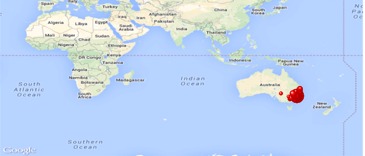
Map should show Australia by default and not the whole world map
My data is just for the Australian post codes and I want the map to show only that. But not sure why it shows the entire world map.
- « Previous Replies
- Next Replies »
Accepted Solutions
- Mark as New
- Bookmark
- Subscribe
- Mute
- Subscribe to RSS Feed
- Permalink
- Report Inappropriate Content
I've found that in your data you have a record with WorkLong and WorkLat = 0 for postcode=2174
If I exclude it the map looks as you need.
Probably the problem is with this record. If you delete or correct it you will get your map
Sergey
- Mark as New
- Bookmark
- Subscribe
- Mute
- Subscribe to RSS Feed
- Permalink
- Report Inappropriate Content
it's difficult to solve if there are no sample.
But in longitude and latitude expression you should use variable like $(var_zoom), which defined as
| var_zoom= | '=max(aggr(if(max( round(256*pow(2,(_zoom_level -1)))+( Longitude *((256*pow(2,_zoom_level ))/360)) )-min( round(256*pow(2,(_zoom_level -1)))+( Longitude *((256*pow(2,_zoom_level ))/360)) ) <map_size_x AND max((256*pow(2,(_zoom_level-1)))+((0.5*log((1+(sin((Latitude)*pi()/180)))/(1-(sin((Latitude)*pi()/180)))))*((-256*pow(2,_zoom_level))/(2*pi()))))-min((256*pow(2,(_zoom_level-1)))+((0.5*log((1+(sin((Latitude)*pi()/180)))/(1-(sin((Latitude)*pi()/180)))))*((-256*pow(2,_zoom_level))/(2*pi()))))<map_size_y,_zoom_level,1),_zoom_level))'; |
for example latitude expression:
((256*pow(2,($(var_zoom)-1)))+((0.5*log((1+(sin((Latitude)*pi()/180)))/(1-(sin((Latitude)*pi()/180)))))*((-256*pow(2,$(var_zoom)))/(2*pi()))))
Sergey
- Mark as New
- Bookmark
- Subscribe
- Mute
- Subscribe to RSS Feed
- Permalink
- Report Inappropriate Content
I have the var_zoom defined. I am attaching my qvw file. Please help.
- Mark as New
- Bookmark
- Subscribe
- Mute
- Subscribe to RSS Feed
- Permalink
- Report Inappropriate Content
Hi Sergey, I have the var_zoom defined that away. I am attaching my qvw file anyway. If you can help that would be great.
Thanks,
Ram
- Mark as New
- Bookmark
- Subscribe
- Mute
- Subscribe to RSS Feed
- Permalink
- Report Inappropriate Content
You have to set the default zoom at the median of longitude and latitude.
- Mark as New
- Bookmark
- Subscribe
- Mute
- Subscribe to RSS Feed
- Permalink
- Report Inappropriate Content
How?
- Mark as New
- Bookmark
- Subscribe
- Mute
- Subscribe to RSS Feed
- Permalink
- Report Inappropriate Content
How you have applied this map....
As the background or Google Map extension Object..??
- Mark as New
- Bookmark
- Subscribe
- Mute
- Subscribe to RSS Feed
- Permalink
- Report Inappropriate Content
applied map already as the background. see the attachment.
- Mark as New
- Bookmark
- Subscribe
- Mute
- Subscribe to RSS Feed
- Permalink
- Report Inappropriate Content
I have not downloaded your app.
Try this
='http://maps.google.com/staticmap?center='
&
num(Min(Latitude)+((Max(Latitude)-Min(Latitude))/2), '##############', '.', ',' )
&
','
&
num(Min(Longitude)+((Max(Longitude)-Min(Longitude))/2), '##############', '.', ',' )
&
'&zoom=$(var_zoom)'
&
'&maptype='&var_maptype
&
'&size='&map_size_x&'x'&map_size_y
&
'&key='&gmap_key & '&.jpg'
check the bold lines in your background, set it as this. Change Latitude and Longitude with the name of the field in your context.
- « Previous Replies
- Next Replies »