Unlock a world of possibilities! Login now and discover the exclusive benefits awaiting you.
- Qlik Community
- :
- Forums
- :
- Analytics
- :
- App Development
- :
- Re: Script generated KML fields with coordinate ?
- Subscribe to RSS Feed
- Mark Topic as New
- Mark Topic as Read
- Float this Topic for Current User
- Bookmark
- Subscribe
- Mute
- Printer Friendly Page
- Mark as New
- Bookmark
- Subscribe
- Mute
- Subscribe to RSS Feed
- Permalink
- Report Inappropriate Content
Script generated KML fields with coordinate ?
Hi All,
In Qlik Sense it look like it's possible to load a KML in the script to overlay the standard map with forms.
I've in my data some coordinates, longitude and latitude for a start and End points, and I've the feeling that it should be possible to create "lines" in the KML sense in the script to make this dynamic (new coordinate = new lines without having to build a KML file).
Has anyone done that already ?
I will keep trying, if some has done that...
Thank-you.
- Mark as New
- Bookmark
- Subscribe
- Mute
- Subscribe to RSS Feed
- Permalink
- Report Inappropriate Content
Hi,
Partial answer
just add a field in the script where the coordinates are :
,'[[[['& OrigLon &CHR(44)& OrigLat &']'&CHR(44)
&'['& DestLon &CHR(44)& DestLat &']]]]' as Line
and add a command
TAG FIELDS "Line" WITH $geopolygon;
that create lines on the map.
Warning : if there is too many polygons, the map is not displayed. I started with more than 6000, it did not work, with around 600 it's working.
But the line is black, and the indicator have no effect.
I suppose that I can the same way create a 4 corner polygon, a line thicker by few fraction of degree. That will allows to have a filling that will change color.
But it look like messy as I need to calculate an offset that depend on the angle of the line... I don't even want to try.
Any better idea ?
Stephane.
- Mark as New
- Bookmark
- Subscribe
- Mute
- Subscribe to RSS Feed
- Permalink
- Report Inappropriate Content
Hi Stephane,
Another option would be to use IdevioMaps, handles very well on-the-fly generated lines. Width and color of the line can then be controlled with Qlik expressions. Here's small examples where street data from Open Barcelona is parsed and combined with traffic information.
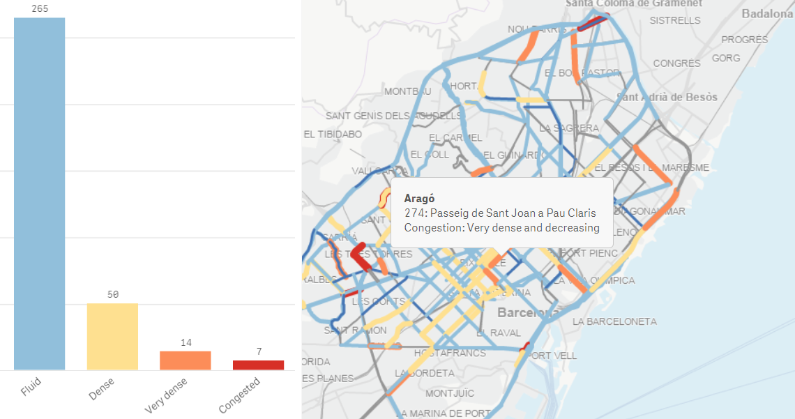
In this case the indata looked like this:
2.11203535639414,41.3841912394771,0 2.101502862881051,41.3816307921222,0
and was formatted at load time to: [[long1,lat1],[long2,lat2],...]
We would be happy to send you a test license, just visit Contact Form « idevio.com to request one!
Thanks,
Patric Nordström
Idevio
- Mark as New
- Bookmark
- Subscribe
- Mute
- Subscribe to RSS Feed
- Permalink
- Report Inappropriate Content
Hi!
Did you manage to get this to work?
Whenever I try this I get "Error - JSON protocol parse error" in the map. I tag the dimension with $geomultipolygon but still the map shows below, although it recognizes the field as an area map.

Cheers,
Erik