Unlock a world of possibilities! Login now and discover the exclusive benefits awaiting you.
- Qlik Community
- :
- Forums
- :
- Analytics
- :
- New to Qlik Analytics
- :
- Re: Map object
- Subscribe to RSS Feed
- Mark Topic as New
- Mark Topic as Read
- Float this Topic for Current User
- Bookmark
- Subscribe
- Mute
- Printer Friendly Page
- Mark as New
- Bookmark
- Subscribe
- Mute
- Subscribe to RSS Feed
- Permalink
- Report Inappropriate Content
Map object
Hi All,
I am using the free qlik cloud version for creating map but for some of the location the bubble is not showing in the right location as for example Rochester, NY and also Greenville, SC.
Also how do I change the color for the particular bubble.
Thanks in advance.
- Mark as New
- Bookmark
- Subscribe
- Mute
- Subscribe to RSS Feed
- Permalink
- Report Inappropriate Content
May be make 2 new columns
Latitude
Longitude
And use the Latitude without ° N
And same for Longitude, without ° W. Instead of ° W use - for Longitude.
As below Image.
Example: Rochester, NY : 43.1610, -77.6109
If it a local file it won't be much of a problem to change/hardcode the values.
After you have Latitude & Longitude loaded
Use the following syntax in script....
Ex script:
LOAD
1.Region,
2.Site Location - Country,
3. Site Location - City,
Latitude,
Longitude,
GeoMakePoint(Latitude,Longitude) as GeoKey
GeoMakePoint(Latitude,Longitude) as GeoKey <<<
Use GeoKey as Point Layer in your Map as Dimension.
Thanks.
- Mark as New
- Bookmark
- Subscribe
- Mute
- Subscribe to RSS Feed
- Permalink
- Report Inappropriate Content
Hi,
Do I have to change all the longitude - even though its East. I tried doing - for the west ones and its not working still as well as not I am not being able to see the properties or point layer section. Below is the screenshot:-

- Mark as New
- Bookmark
- Subscribe
- Mute
- Subscribe to RSS Feed
- Permalink
- Report Inappropriate Content
Hi arvind654,
It worked thanks so much. Below is the map.

- Mark as New
- Bookmark
- Subscribe
- Mute
- Subscribe to RSS Feed
- Permalink
- Report Inappropriate Content
Rochester, NY : 43.1610, 43.1610
Latitude should be with out any sign (+or-) just numbers (ex:43.1610)
Longitude should always be with - sign (ex: -77.6109)
Make 2 separate columns
State Latitude Longitude
NY 43.1610 43.1610
....
..... so on
The Region field should match with given Lat & Long.
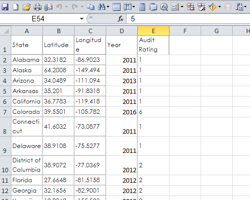
Find the Sample attachment XL file for your reference. Your data should be in similar fashion.
If you do not have audit or Year in same file it is fine. You can always make a link to the Lat & Long Data
Or you can load State or Region name in other file to make a link to the Lat& Long.
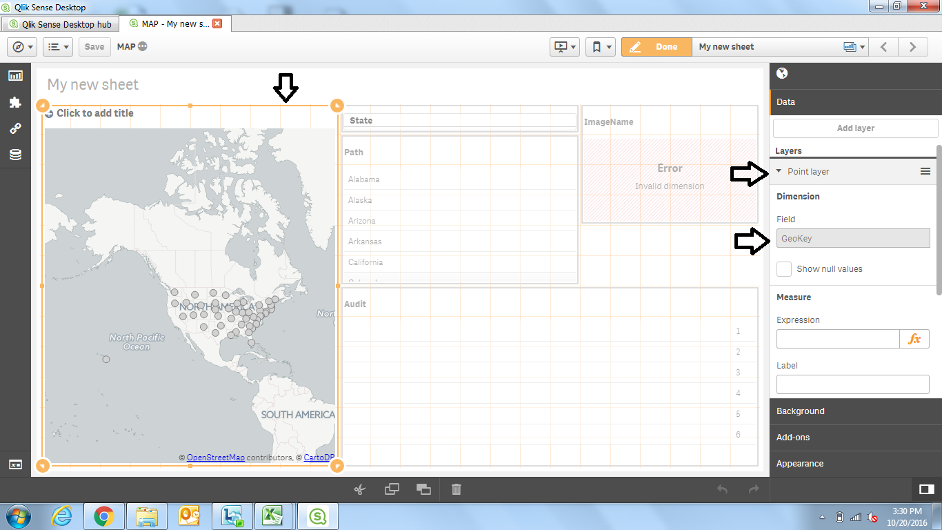
In above image you check the properties
Edit>Click on the Map object>Properties will show> you'll see Points Layer as a dimension field
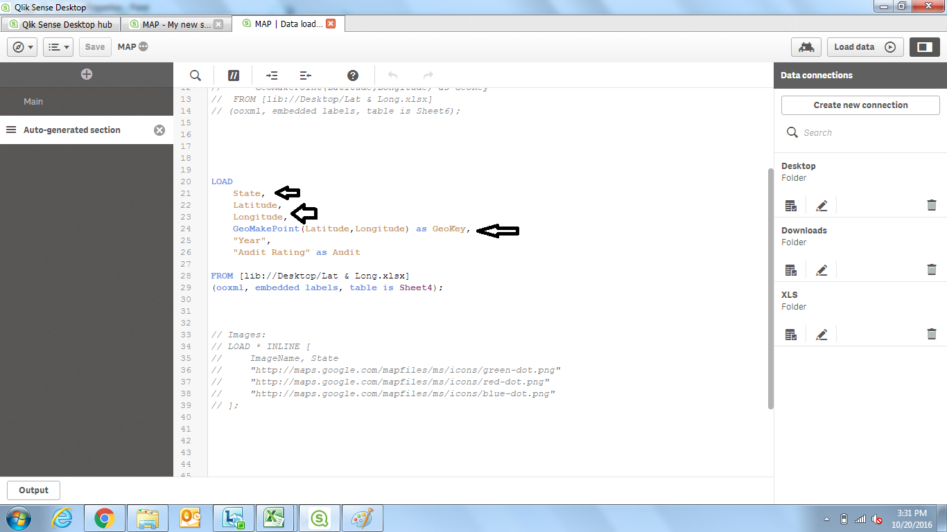
In below image you see is the script
I've loaded the XL file having fields
State, Latitude, Longitude, Year and audit
So I added a syntax
GeoMakePoint(Latitude,Longitude) as GeoKey,
I used GeoKey in my Points Layer as a Dimension.
Thanks.
- Mark as New
- Bookmark
- Subscribe
- Mute
- Subscribe to RSS Feed
- Permalink
- Report Inappropriate Content
If you still find it confusing, attach your data file here (if not confidential) and I'll edit the data and give it back to you?
Thanks.
- Mark as New
- Bookmark
- Subscribe
- Mute
- Subscribe to RSS Feed
- Permalink
- Report Inappropriate Content
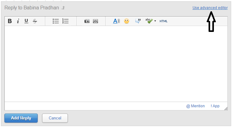
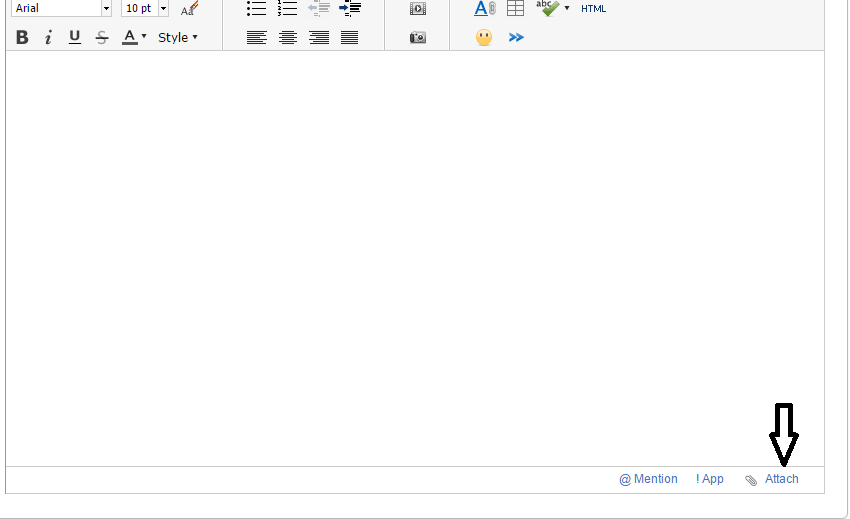
How do I attach the test file I am not seeing any option and I thought it worked but its still not working. Is it possible for you to share how do I share the data.
- Mark as New
- Bookmark
- Subscribe
- Mute
- Subscribe to RSS Feed
- Permalink
- Report Inappropriate Content
Hi Arvind,
Thanks for all your help below is the data that I am using. I am not sure how to attach the file. I think the map is coming correct for US but for Munich, Milan and Hastings its off now.


- Mark as New
- Bookmark
- Subscribe
- Mute
- Subscribe to RSS Feed
- Permalink
- Report Inappropriate Content
No problem.
If you found your solution, mark it as correct so that it will be helpful for others in future.
Thanks.
- Mark as New
- Bookmark
- Subscribe
- Mute
- Subscribe to RSS Feed
- Permalink
- Report Inappropriate Content
Hi arvind654,
The map seems to be coming out correct for Rochester and Greenville but for Munich, Milan and Hastings its not coming out correct. Can you also let me know how do I attach excel sheet to the discussion forum. I really appreciate your help.Thanks.
Below is the test data and map. Please let me know if you have any question.


- Mark as New
- Bookmark
- Subscribe
- Mute
- Subscribe to RSS Feed
- Permalink
- Report Inappropriate Content
Click on advance editor and follow the arrows in the images. You'll be able to upload your sample data.
Also please mention what expressions you using for colors and etc. So that I will be able to replicate same like you.
Thanks.