Unlock a world of possibilities! Login now and discover the exclusive benefits awaiting you.
- Qlik Community
- :
- All Forums
- :
- QlikView Administration
- :
- Re: Idevio Maps for QlikView
- Subscribe to RSS Feed
- Mark Topic as New
- Mark Topic as Read
- Float this Topic for Current User
- Bookmark
- Subscribe
- Mute
- Printer Friendly Page
- Mark as New
- Bookmark
- Subscribe
- Mute
- Subscribe to RSS Feed
- Permalink
- Report Inappropriate Content
Idevio Maps for QlikView
Hi,
We want to share a new extension, Idevio Maps for QlikView. Here's a screenshot:
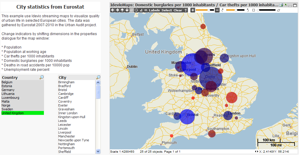
In short, the pros:
- Fast map with dynamic zoom and pan.
- Client side rendering, handles thousands of objects with ease.
- Plug and play, easy to setup and configure.
- Extendable, the extension serves as a starting point.
- World coverage, street level in many areas.
For those who are keen on tech details:-) the extension is connected to our web-based map engine Idevio WebMap. Maps are streamed from our server. Two dimensions with longitude and latitude coordinates WGS84 are required. Objects can be shown as bubble, pie or bar diagrams or an arbitrary url image. The size of and color are controlled via dimensions, normalized based on max and min in the selection. Web Map has a javascript interface with a dual implementation: if java is present on the client, maps are rendered on the client, otherwise the maps are shown as server side rendered images.
We, Idevio, specialize in hi-performance map engines for defense and industry, and we're happy to find a great match for our engine in QlikView! We are based in Göteborg, Sweden, and since 2002 we supply map engines for web, mobile and embedded devices to esteemed clients such as Ericsson, Logica, Saab, Schenker, Thales and G4S.
Contact me if you want to try the extension. We can also with other map services: address matching, routing, geofencing, map matching, map data sourcing and distribution. There's a web-based demo of the extension at www.idevio.com/demo, log on with username: demo, password: demo. Would be great to hear your feedback!
Cheers,
Patric Nordström, Idevio
+46 31 779 09 60
- « Previous Replies
-
- 1
- 2
- Next Replies »
- Mark as New
- Bookmark
- Subscribe
- Mute
- Subscribe to RSS Feed
- Permalink
- Report Inappropriate Content
The easiest way to get in contact is through our web form or send a email to me (patric.nordstrom@idevio.com).
Cheers,
Patric
- Mark as New
- Bookmark
- Subscribe
- Mute
- Subscribe to RSS Feed
- Permalink
- Report Inappropriate Content
Can we link dots on Google map with a line,
Like a network etc??
- Mark as New
- Bookmark
- Subscribe
- Mute
- Subscribe to RSS Feed
- Permalink
- Report Inappropriate Content
I have From and To co-ordinates where I have to show the routing between those co-ordinates. is that possible in idevio maps???
- Mark as New
- Bookmark
- Subscribe
- Mute
- Subscribe to RSS Feed
- Permalink
- Report Inappropriate Content
Hi Sandeep,
Yes, it is a function within IdevioMaps. Geocoding, routing, iso-line routing and route optimization is some ot the functions within IdevioMaps. Just drop us an email at info@idevio.com and we can provide you with some examples.
BR
/Jonas
- Mark as New
- Bookmark
- Subscribe
- Mute
- Subscribe to RSS Feed
- Permalink
- Report Inappropriate Content
Hi Jonas,
I have some queries regarding Idevio Maps for Qlikview:
1. Is it possible to create custom territory by consolidating zip codes ?
2. If yes, whether we need to create Zip-territory mapping manually or Idevio does this on its own?
3. Can Idevio Maps automate this consolidation of zips into custom territory.
Please share if you have any related examples.
Thanks & Regards,
Sabahat
- Mark as New
- Bookmark
- Subscribe
- Mute
- Subscribe to RSS Feed
- Permalink
- Report Inappropriate Content
Hi Jonas,
Waiting for your response.
Regards,
Sabahat
- Mark as New
- Bookmark
- Subscribe
- Mute
- Subscribe to RSS Feed
- Permalink
- Report Inappropriate Content
Hi,
As of jan this year IdevioMaps is Qlik GeoAnalytics. For more info please visit:
1. Yes it is.
2. That's whats required, a translation table with zip code mapped to custom territory name.
2. Yes, please take a look at the "Dissolve operation", that will do what you want.
Thanks,
Patric Nordström
Qlik
- « Previous Replies
-
- 1
- 2
- Next Replies »