Unlock a world of possibilities! Login now and discover the exclusive benefits awaiting you.
- Qlik Community
- :
- Forums
- :
- Analytics
- :
- New to Qlik Analytics
- :
- Re: Qlik Sense Map
- Subscribe to RSS Feed
- Mark Topic as New
- Mark Topic as Read
- Float this Topic for Current User
- Bookmark
- Subscribe
- Mute
- Printer Friendly Page
- Mark as New
- Bookmark
- Subscribe
- Mute
- Subscribe to RSS Feed
- Permalink
- Report Inappropriate Content
Qlik Sense Map
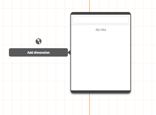
Hi, I'm creating a map using Qlik Sense, following some instruction videos on Qlik Sense, but strangely after I load my data with lat and long, I still have no dimensions available to create the map when I click the "Add Dimension" button. Please see a screen shot that I added here.
What did I miss here? Thanks for help!
X
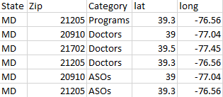
my data:
screen shot:
- Tags:
- chart
- map
- qlik sense
- « Previous Replies
- Next Replies »
- Mark as New
- Bookmark
- Subscribe
- Mute
- Subscribe to RSS Feed
- Permalink
- Report Inappropriate Content
Hi,
FYI:
Loading map data
To be able to create a map visualization, you need access to geographical data that connects to the data in your app. Geographical data comes in the form of either:
- geopoint data (latitude, longitude) for a single location, such as a city
- area data (polygons of geopoints) to represent regions or countries
When you use Add data, Qlik Sense will try to recognize if your data contains cities or countries. If successful, a new field containing geographical information is created automatically.
When using Add data, you must select Prepare data instead of Load data and finish. If you select Load data and finish, the geographical data is not detected and the new field containing geographical information is not created.
- Mark as New
- Bookmark
- Subscribe
- Mute
- Subscribe to RSS Feed
- Permalink
- Report Inappropriate Content
Hi @JonnyPoole
I am also facing same issue I have done this step in Data load editor but how to copy background URL can you please help me.
.png)
- « Previous Replies
- Next Replies »