Unlock a world of possibilities! Login now and discover the exclusive benefits awaiting you.
- Qlik Community
- :
- Forums
- :
- Analytics
- :
- New to Qlik Analytics
- :
- Re: Need help in creating maps in Qliksense
- Subscribe to RSS Feed
- Mark Topic as New
- Mark Topic as Read
- Float this Topic for Current User
- Bookmark
- Subscribe
- Mute
- Printer Friendly Page
- Mark as New
- Bookmark
- Subscribe
- Mute
- Subscribe to RSS Feed
- Permalink
- Report Inappropriate Content
Need help in creating maps in Qliksense
Hi,
I have found three ways of implementing maps in Qliksense. Please let me know which is the best approach
- https://www.geoqlik.com/en/geoqlik-for-qlik-sense.html
- http://www.qlikmaps.com/
- https://community.qlik.com/docs/DOC-17940
Apart from these three options please let me know if there is any other way to implement drill down @maps in qliksense. (free of cost)
- Mark as New
- Bookmark
- Subscribe
- Mute
- Subscribe to RSS Feed
- Permalink
- Report Inappropriate Content
I will do !
do you have strict need about the type of the map representation (points or areas) ?
Because maybe one of them is not possible with multi layer
- Mark as New
- Bookmark
- Subscribe
- Mute
- Subscribe to RSS Feed
- Permalink
- Report Inappropriate Content
Yes i do have. But its OK if everything is not achievable. I can manage. My main focus is on association and drill down from Region->Division->Territory.
Thanks for your efforts 
- Mark as New
- Bookmark
- Subscribe
- Mute
- Subscribe to RSS Feed
- Permalink
- Report Inappropriate Content
Hi - it is a one table. and association key is only POSITION_NBR and its working I believe for data arrangement you have to use would have to use hierarchybelongsto for Load. can you make a simple example data so that i can help you with that would be easy for me to understand.
- Mark as New
- Bookmark
- Subscribe
- Mute
- Subscribe to RSS Feed
- Permalink
- Report Inappropriate Content
Hi
I am replaying on behalf of ayeesha.
please find the simple example file
regards
mahesh
- Mark as New
- Bookmark
- Subscribe
- Mute
- Subscribe to RSS Feed
- Permalink
- Report Inappropriate Content
Lots of work needs to be done.
I would say bring KML file to Excel
Divison should have Division polygon. and Territory should have Territory right now it's all mixed.
load it from Excel after the load syntax you have to tag it with polygons.
Sorry, can't help more than that.
- Mark as New
- Bookmark
- Subscribe
- Mute
- Subscribe to RSS Feed
- Permalink
- Report Inappropriate Content
Hi,
I'm not good at the US geography but you think it is custom areas ? otherwise they can download "ready to use" US KML Files..
what do you think ?
- Mark as New
- Bookmark
- Subscribe
- Mute
- Subscribe to RSS Feed
- Permalink
- Report Inappropriate Content
No it's not custom areas but it has all layers in one. you have to define it clearly with whom you are associating. I am not saying to custom the map but association.
Thank you
- Mark as New
- Bookmark
- Subscribe
- Mute
- Subscribe to RSS Feed
- Permalink
- Report Inappropriate Content
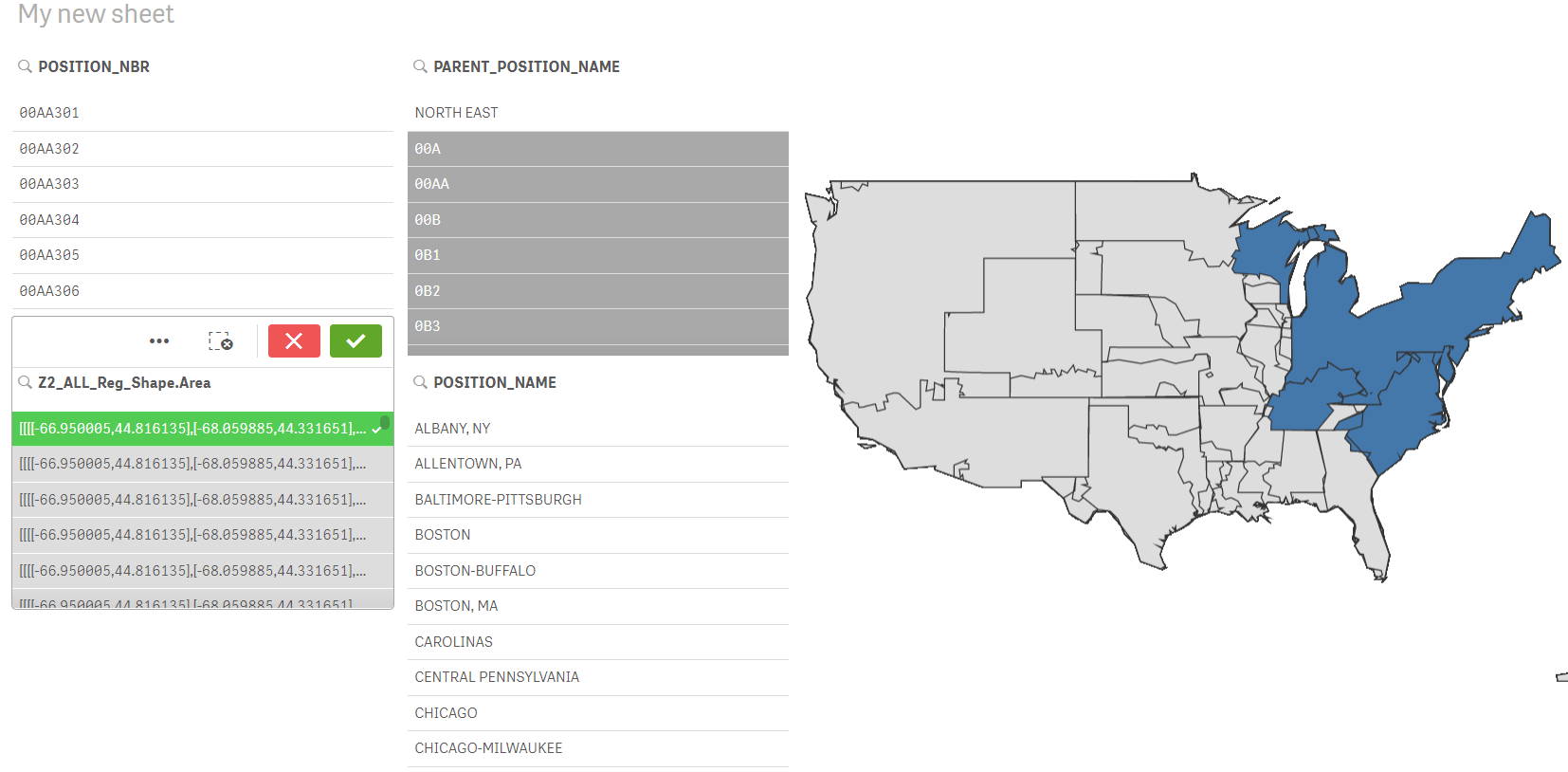
Thanks Jahanzeb. Appreciate your efforts in explaining the issue.
Can you share the Qliksense file from which you have taken the above snapshot.
I think you have tried something on Qliksense app. Could you please share it.
- Mark as New
- Bookmark
- Subscribe
- Mute
- Subscribe to RSS Feed
- Permalink
- Report Inappropriate Content
I dont know about custom areas as i am new to Qliksense. Actually i cant use ready to use US KML file. I am suppose to use only attached one. Please help me
- Mark as New
- Bookmark
- Subscribe
- Mute
- Subscribe to RSS Feed
- Permalink
- Report Inappropriate Content
Actually i am new to Qliksense hence i have no idea about polygons and how to use it with maps. It would be great if you can share some documents on it or any sample application.