Unlock a world of possibilities! Login now and discover the exclusive benefits awaiting you.
- Qlik Community
- :
- Forums
- :
- Analytics
- :
- New to Qlik Analytics
- :
- Re: Need help in creating maps in Qliksense
- Subscribe to RSS Feed
- Mark Topic as New
- Mark Topic as Read
- Float this Topic for Current User
- Bookmark
- Subscribe
- Mute
- Printer Friendly Page
- Mark as New
- Bookmark
- Subscribe
- Mute
- Subscribe to RSS Feed
- Permalink
- Report Inappropriate Content
Need help in creating maps in Qliksense
Hi,
I have found three ways of implementing maps in Qliksense. Please let me know which is the best approach
- https://www.geoqlik.com/en/geoqlik-for-qlik-sense.html
- http://www.qlikmaps.com/
- https://community.qlik.com/docs/DOC-17940
Apart from these three options please let me know if there is any other way to implement drill down @maps in qliksense. (free of cost)
- « Previous Replies
- Next Replies »
- Mark as New
- Bookmark
- Subscribe
- Mute
- Subscribe to RSS Feed
- Permalink
- Report Inappropriate Content
Please find the file with cbsa KML map
- Mark as New
- Bookmark
- Subscribe
- Mute
- Subscribe to RSS Feed
- Permalink
- Report Inappropriate Content
oops, I tried to take my example off, it took the thread.
- Mark as New
- Bookmark
- Subscribe
- Mute
- Subscribe to RSS Feed
- Permalink
- Report Inappropriate Content
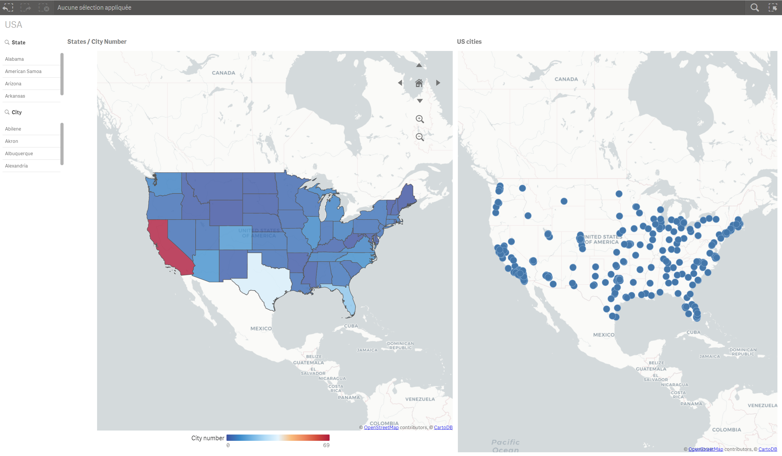
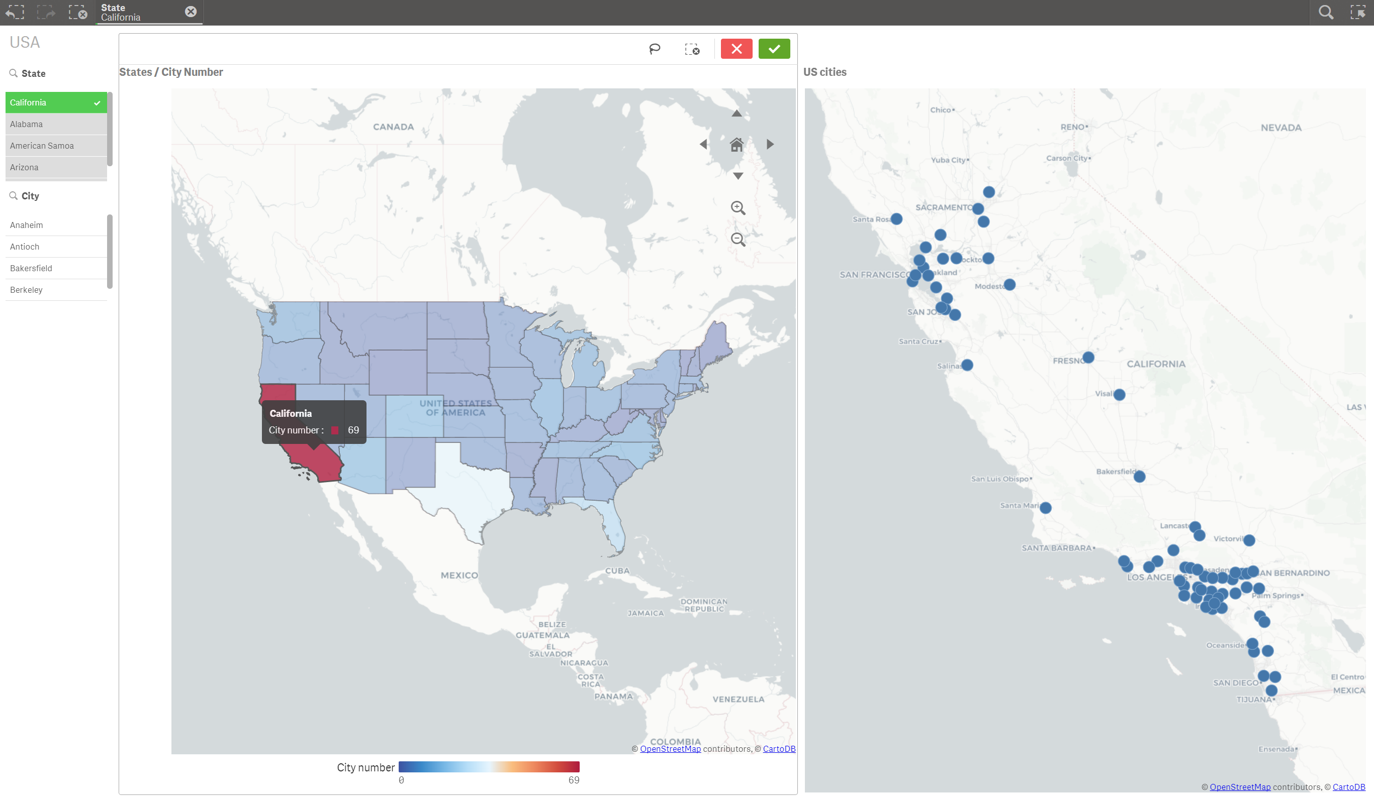
Hi,
here is what you can do with the Map chart of Qliksense, find attached an example with a drill down of only two dimensions (States and cities)
Clean mapped geo data dimensions are difficult to found... i make this example app for you with what i found
in this example you can find cities number per State
before "drill down":
after "drill down"
here is the code:
city_points:
LOAD
State,
City,
TextBetween(Location,'','N')&'000' as latitude,
'-'&TextBetween(Location,' ','W') as longitude,
GeoMakePoint(TextBetween(Location,'','N')&'000', '-'&TextBetween(Location,' ','W')) as geopoints
FROM [lib://kml files/Copie de List of cities in US.xlsx]
(ooxml, embedded labels, table is [List of cities in US]);
right join
states_area:
LOAD
TextBetween("cb_2016_us_state_500k.Name",left("cb_2016_us_state_500k.Name",15), right("cb_2016_us_state_500k.Name",12)) as State,
"cb_2016_us_state_500k.Area"
FROM [lib://kml files/cb_2016_us_state_500k.kml]
(kml, Table is [cb_2016_us_state_500k/cb_2016_us_state_500k])
where not match(TextBetween("cb_2016_us_state_500k.Name",left("cb_2016_us_state_500k.Name",15), right("cb_2016_us_state_500k.Name",12))
,'Alaska','Guam','Commonwealth of the Northern Mariana Islands','Hawaii','Puerto Rico','United States Virgin Islands') ;
basically we have two tables (Points and Areas)
first table contain our 2 dimensions (States and cities), correctly mapped, with only the coordinates of the cities
second table we have the states with the polygons (the areas).
the key is the State
PS:to have a real "drill down" I created a hierarchy group with State->city and i use it on the map, but when i click on a state a message saying "the result of the hypercube is too big"
Maybe this is an issue..
hope it helps
- Mark as New
- Bookmark
- Subscribe
- Mute
- Subscribe to RSS Feed
- Permalink
- Report Inappropriate Content
Thanks Youssef for providing solution. This will really help me to achieve my objective.
- Mark as New
- Bookmark
- Subscribe
- Mute
- Subscribe to RSS Feed
- Permalink
- Report Inappropriate Content
Toi can take a look at this also:
Geographic 'Drill Down' (Areas and Points) for US MAP
There is more details and tips
- « Previous Replies
- Next Replies »