Unlock a world of possibilities! Login now and discover the exclusive benefits awaiting you.
- Qlik Community
- :
- Forums
- :
- Analytics
- :
- New to Qlik Analytics
- :
- Re: Can't create points using map chart
- Subscribe to RSS Feed
- Mark Topic as New
- Mark Topic as Read
- Float this Topic for Current User
- Bookmark
- Subscribe
- Mute
- Printer Friendly Page
- Mark as New
- Bookmark
- Subscribe
- Mute
- Subscribe to RSS Feed
- Permalink
- Report Inappropriate Content
Can't create points using map chart
Hello there. I'm using Qlik Sense Desktop, the latest version (downloaded last week).
I'm using a csv file as the data source for my application.
I've done all other charts for my app, but the map doesn't work in anyway I try it.
The csv looks like this (is quite big, 16 fields).
| date | driver_name | Latitude | Longitude | ... |
|---|---|---|---|---|
| 2018-05-01 19:03:21 | John | -23.40600166 | -44.468035 | ... |
| 2018-05-01 19:03:44 | Eric | -4.18610166 | -44.468035 | ... |
| 2018-05-01 21:02:50 | Mike | -23.40599166 | -46.404655 | ... |
| 2018-05-02 12:02:50 | Carl | -23.40599166 | -46.404655 | ... |
Some fields may repeat. The only "geo" fields are latitude and longitude.
Qlik doesn't recognize the Latitude and Longitude when creating point maps.
I created a dimension called location using GeoMakePoint(Latitude, Longitude), created a map using this as dimension, but it doesn't show anything.
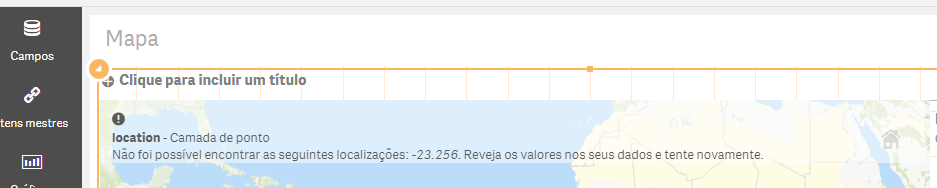
With the full file, it says there's an error in a latitude field, but searching in the file there isn't (a field with -23.256 value, image below in portuguese).
Using the first 6 lines, it doesn't work either.
Using six lines with no latitude/longitude repeating, it doesn't work.
Would be glad if someone finds an answer to this.
Accepted Solutions
- Mark as New
- Bookmark
- Subscribe
- Mute
- Subscribe to RSS Feed
- Permalink
- Report Inappropriate Content
I've found the answer myself. It is pretty stupid.
Qlik does not recognize this notation: -23.40..., -44.46
Switching for "-23,40...", "-44,46..." works.
- Mark as New
- Bookmark
- Subscribe
- Mute
- Subscribe to RSS Feed
- Permalink
- Report Inappropriate Content
I've found the answer myself. It is pretty stupid.
Qlik does not recognize this notation: -23.40..., -44.46
Switching for "-23,40...", "-44,46..." works.