Unlock a world of possibilities! Login now and discover the exclusive benefits awaiting you.
- Qlik Community
- :
- All Forums
- :
- QlikView Integrations
- :
- Re: Help needed with qlikview google maps
- Subscribe to RSS Feed
- Mark Topic as New
- Mark Topic as Read
- Float this Topic for Current User
- Bookmark
- Subscribe
- Mute
- Printer Friendly Page
- Mark as New
- Bookmark
- Subscribe
- Mute
- Subscribe to RSS Feed
- Permalink
- Report Inappropriate Content
Help needed with qlikview google maps
Hi all,
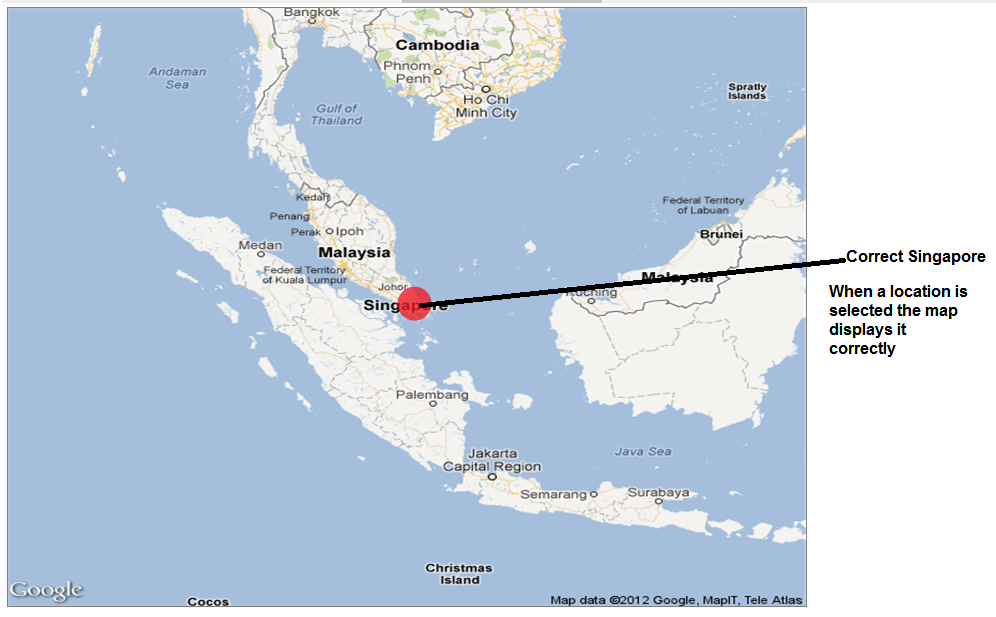
Im using google maps in qlikview and everything works fine.the latitude and longitude are correct.But when nothing is selected the llocations are shown in wrong place and when a particular location is selected it is shown correctly on the map.when i lower the resolution from 800*600 to something lower the maps shows the locations fine on the map.Please see the attached pictures.So is there any problem with the pixels in my map or anything else?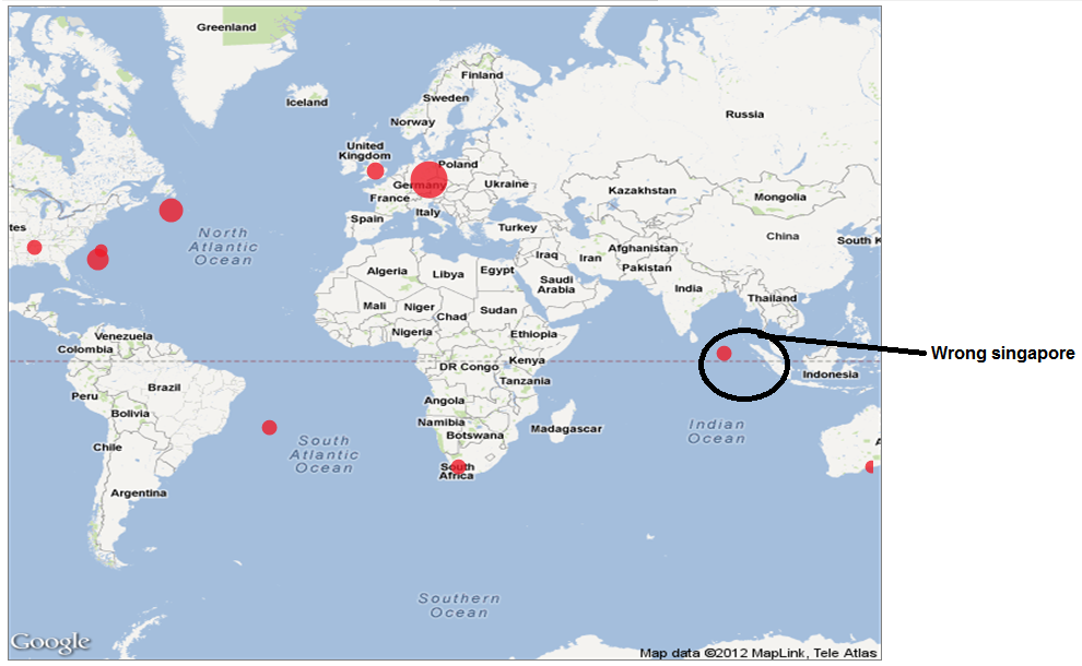
Accepted Solutions
- Mark as New
- Bookmark
- Subscribe
- Mute
- Subscribe to RSS Feed
- Permalink
- Report Inappropriate Content
Hi,
Know that this is an old post, but I had the exact same problem and found the solution here :
http://community.qlik.com/thread/38403
So the problem is, that if you set the mapsize to e.g. 800x600 the scattechart thinks the scale is equal to the mapsize. But the dynamic picture from Google is maximum 600x600 for "free users", and therefore the bubbles are placed wrong compared to the dynamic image.
So follow the code from "pjohn" and your maps will look a lot better 🙂
Kudos to pjohn : http://community.qlik.com/people/pjohn 🙂
Regards,
Messmann
- Mark as New
- Bookmark
- Subscribe
- Mute
- Subscribe to RSS Feed
- Permalink
- Report Inappropriate Content
Ever find a solution to this?
- Mark as New
- Bookmark
- Subscribe
- Mute
- Subscribe to RSS Feed
- Permalink
- Report Inappropriate Content
Hi
Usualy this problem occurs where there is a bad data model.
Suppose you have only one file with duplicate value for your dimension, so the long/lat are duplicated also.
In apps using google maps, we use an expression for longitude like this Sum( round (256*pow(2,($(var_zoom)-1.....). The sum could create the problem.
2 solution :
- change sum with avg
- improve your data model keeping a table with only the locations.
Try it
JJ
- Mark as New
- Bookmark
- Subscribe
- Mute
- Subscribe to RSS Feed
- Permalink
- Report Inappropriate Content
Hi,
Know that this is an old post, but I had the exact same problem and found the solution here :
http://community.qlik.com/thread/38403
So the problem is, that if you set the mapsize to e.g. 800x600 the scattechart thinks the scale is equal to the mapsize. But the dynamic picture from Google is maximum 600x600 for "free users", and therefore the bubbles are placed wrong compared to the dynamic image.
So follow the code from "pjohn" and your maps will look a lot better 🙂
Kudos to pjohn : http://community.qlik.com/people/pjohn 🙂
Regards,
Messmann
- Mark as New
- Bookmark
- Subscribe
- Mute
- Subscribe to RSS Feed
- Permalink
- Report Inappropriate Content
I was able to solve the problem by reducing the resolution at that time.