Unlock a world of possibilities! Login now and discover the exclusive benefits awaiting you.
- Qlik Community
- :
- All Forums
- :
- QlikView App Dev
- :
- Re: Google Maps Problem
- Subscribe to RSS Feed
- Mark Topic as New
- Mark Topic as Read
- Float this Topic for Current User
- Bookmark
- Subscribe
- Mute
- Printer Friendly Page
- Mark as New
- Bookmark
- Subscribe
- Mute
- Subscribe to RSS Feed
- Permalink
- Report Inappropriate Content
Google Maps Problem
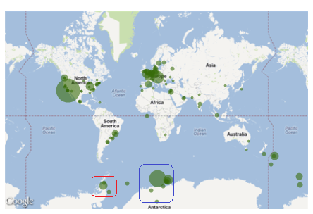
I am using Google Maps in an app I am developing copied mostly from the What's New in QV11 app. The problem I am experiencing is that when no selections are made (the world) I see lot's of green in the southern oceans near Antarctica in additon to the normal distribution you would expect. The strange thing is that the layout of the dots in the ocean corresponds somewhat to it's northern counterparts. If you look at the attached picture, the red outline is really California while the blue outline is the east coast.
As soon as you make a geographical selection, filtering the map, it starts behaving correctly. So if you select the red outline, for example it drills down to a map of California.
Can anyone give me an idea as to why the primary image would be misaligned but subsequent selection images are fine?
- Mark as New
- Bookmark
- Subscribe
- Mute
- Subscribe to RSS Feed
- Permalink
- Report Inappropriate Content
I got a similar problem with the values for Australia, what i did was change the lattitude calculation for
Max Step value - Lattitute expresion
- Mark as New
- Bookmark
- Subscribe
- Mute
- Subscribe to RSS Feed
- Permalink
- Report Inappropriate Content
I got a similar problem with the values for Australia, what i did was change the lattitude calculation for
Max Step value - Lattitute expresion