Unlock a world of possibilities! Login now and discover the exclusive benefits awaiting you.
- Qlik Community
- :
- All Forums
- :
- QlikView App Dev
- :
- Determine area size using latitude and longitude p...
- Subscribe to RSS Feed
- Mark Topic as New
- Mark Topic as Read
- Float this Topic for Current User
- Bookmark
- Subscribe
- Mute
- Printer Friendly Page
- Mark as New
- Bookmark
- Subscribe
- Mute
- Subscribe to RSS Feed
- Permalink
- Report Inappropriate Content
Determine area size using latitude and longitude points
Hi community,
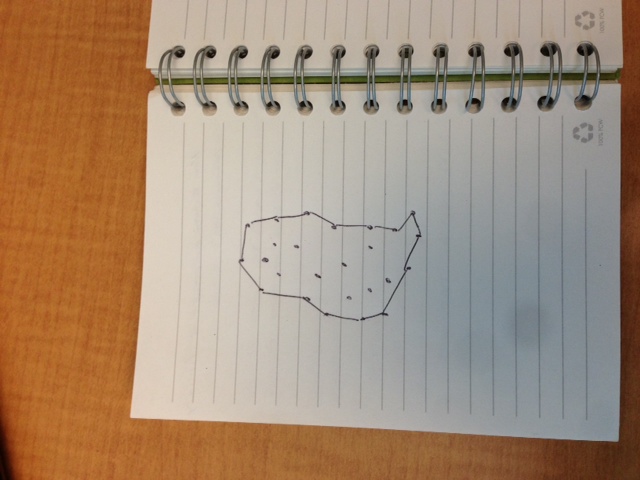
I would like to determine the area (square miles or kilometers, which ever is easier) based on data using latititude and longitude. Basically I want to be able to draw a perimeter using the outer most data points and then calculate the area of this polygon. The approach must be intelligent enough to exclude all the points inside the polygon. I've attached a diagram of what i'm trying to achieve. Hopefully this is clear.
thanks,
- Mark as New
- Bookmark
- Subscribe
- Mute
- Subscribe to RSS Feed
- Permalink
- Report Inappropriate Content
Sure, no problem. Use a GIS tool like ArcGis Desktop (or any of a dozen other). It's purposely built for this kind of geo-spatial analysis.
Or implement an alpha shapes algorithm yourself. Maybe this page can get you started.
talk is cheap, supply exceeds demand
- Mark as New
- Bookmark
- Subscribe
- Mute
- Subscribe to RSS Feed
- Permalink
- Report Inappropriate Content
thanks for the quick reply, however i'm looking for a bit more guidance on this. With the sample data that I attached is there an example that you can show me. One using qlikview or another tool that will know to draw a polygon and calculate the area.
Regards,