Unlock a world of possibilities! Login now and discover the exclusive benefits awaiting you.
- Qlik Community
- :
- All Forums
- :
- QlikView App Dev
- :
- google maps does not appear in QV
- Subscribe to RSS Feed
- Mark Topic as New
- Mark Topic as Read
- Float this Topic for Current User
- Bookmark
- Subscribe
- Mute
- Printer Friendly Page
- Mark as New
- Bookmark
- Subscribe
- Mute
- Subscribe to RSS Feed
- Permalink
- Report Inappropriate Content
google maps does not appear in QV
Hi all,
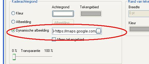
I always use a google map in qv. But recently, the image no longer appears. When I look at properties/colors then I see the following link:
&','&Replace(var_mid_long_c,',','.')&'&zoom=$(var_zoom_c)'&'&maptype='&var_maptype&'&size='&def_map_size_w&'x'&def_map_size_h&'&.jpg)
does anyone know why the image is no longer visible? I think it has to do with the link.
Greetings,
Hans Steenhuis
- Mark as New
- Bookmark
- Subscribe
- Mute
- Subscribe to RSS Feed
- Permalink
- Report Inappropriate Content
That looks like you're using the old V2 api which has been deprecated. You'll need to use the V3 api now.
See this discussion: http://community.qlik.com/message/335685#335685
talk is cheap, supply exceeds demand
- Mark as New
- Bookmark
- Subscribe
- Mute
- Subscribe to RSS Feed
- Permalink
- Report Inappropriate Content
Thanks a lot for your comment. I change the code in:
='http://maps.google.com/staticmap?key='& gmap_key & '¢er='&Replace(var_mid_lat_c,',','.')&','&Replace(var_mid_long_c,',','.')&'&zoom=$(var_zoom_c)'&'&maptype='&var_maptype&'&size='&def_map_size_w&'x'&def_map_size_h&'&.jpg'
In the Load screen is the folowing code:
def_map_size = '624';
def_zoom_level = '6';
def_map_size_h = '624';
def_map_size_w = '624';
var_lat_offset = '0';
// var_mid_long_c = '=median(longitude)';
var_mid_long_c = '=min(longitude)+(max(longitude)-min(longitude))/2';
// var_mid_lat_c = '=median(latitude)';
var_mid_lat_c = '=min(latitude)+((max(latitude)-min(latitude))/2)';
var_zoom = '=max(aggr(if(max( round(256*pow(2,(_zoom_level -1)))+( longitude *((256*pow(2,_zoom_level ))/360)) )-min( round(256*pow(2,(_zoom_level -1)))+( longitude *((256*pow(2,_zoom_level ))/360)) ) <map_size_x AND max((256*pow(2,(_zoom_level-1)))+((0.5*log((1+(sin((latitude)*pi()/180)))/(1-(sin((latitude)*pi()/180)))))*((-256*pow(2,_zoom_level))/(2*pi()))))-min((256*pow(2,(_zoom_level-1)))+((0.5*log((1+(sin((latitude)*pi()/180)))/(1-(sin((latitude)*pi()/180)))))*((-256*pow(2,_zoom_level))/(2*pi()))))<map_size_y,_zoom_level,1),_zoom_level))';
var_maptype_n = '=if(isnull(only(maptype)),fieldvalue( '&chr(39)&'maptype'&chr(39)&', 1 ),maptype)';
var_maptype = '=if(isnull(only(maptype)),fieldvalue( '&chr(39)&'maptype'&chr(39)&', 1 ),maptype)';
var_maptype_z = '=fieldvalue( '&chr(39)&'maptype'&chr(39)&', 5 )'
var_zoom_c = '=if(max(aggr(if(max( round(256*pow(2,(zoom_level -1)))+( longitude *((256*pow(2,zoom_level ))/360)) )-min( round(256*pow(2,(zoom_level -1)))+( longitude *((256*pow(2,zoom_level ))/360)) ) <def_map_size AND max((256*pow(2,(zoom_level-1)))+((0.5*log((1+(sin((latitude)*pi()/180)))/(1-(sin((latitude)*pi()/180)))))*((-256*pow(2,zoom_level))/(2*pi()))))-min((256*pow(2,(zoom_level-1)))+((0.5*log((1+(sin((latitude)*pi()/180)))/(1-(sin((latitude)*pi()/180)))))*((-256*pow(2,zoom_level))/(2*pi()))))<def_map_size,zoom_level,null()),zoom_level))>def_zoom_level, max(aggr(if(max( round(256*pow(2,(zoom_level -1)))+( longitude *((256*pow(2,zoom_level ))/360)) )-min( round(256*pow(2,(zoom_level -1)))+( longitude *((256*pow(2,zoom_level ))/360)) ) <def_map_size AND max((256*pow(2,(zoom_level-1)))+((0.5*log((1+(sin((latitude)*pi()/180)))/(1-(sin((latitude)*pi()/180)))))*((-256*pow(2,zoom_level))/(2*pi()))))-min((256*pow(2,(zoom_level-1)))+((0.5*log((1+(sin((latitude)*pi()/180)))/(1-(sin((latitude)*pi()/180)))))*((-256*pow(2,zoom_level))/(2*pi()))))<def_map_size,zoom_level,null()),zoom_level)),def_zoom_level)-1';
var_zoom_1 = '=var_zoom_c + 1';
var_XMin_c = '=((256*pow(2,((var_zoom_c)-1)))+((var_mid_long_c)*((256*pow(2,(var_zoom_c)))/360))-(def_map_size*0.5))';
var_XMax_c = '=((256*pow(2,((var_zoom_c)-1)))+((var_mid_long_c)*((256*pow(2,(var_zoom_c)))/360))+(def_map_size*0.5))';
var_YMin_c = '=((256*pow(2,((var_zoom_c)-1)))+((0.5*log((1+(sin((var_mid_lat_c)*pi()/180)))/(1-(sin((var_mid_lat_c)*pi()/180)))))*((-256*pow(2,(var_zoom_c)))/(2*pi())))+(def_map_size*0.5))';
var_YMax_c = '=((256*pow(2,((var_zoom_c)-1)))+((0.5*log((1+(sin((var_mid_lat_c)*pi()/180)))/(1-(sin((var_mid_lat_c)*pi()/180)))))*((-256*pow(2,(var_zoom_c)))/(2*pi())))-(def_map_size*0.5))';
// Google Maps in QlikView
// V0.85.2 - October 1st 2008 © Copyright QlikTech International AB 2008 / AES
// Google Maps Key
// get a key here http://code.google.com/apis/maps/signup.html
gmap_key = 'xx';
max_zoom_level = 17; //maximum value 17
// Variables required for calculating map
// No need to change these
// var_pi180= '=pi()/180';
// var_lat_offset= '0';
// var_mc2= '=256*pow(2,$(var_zoom))';
// var_mc1= '=256*pow(2,($(var_zoom)-1))';
// var_mid_lat-c = '=min(latitude)+(1+var_lat_offset)*((max(latitude)-min(latitude))/2)';
// var_mid_long-c = '=min(longitude)+(max(longitude)-min(longitude))/2';
// var_zoom= '=max(aggr(if(max( round(256*pow(2,(_zoom_level -1)))+( longitude *((256*pow(2,_zoom_level ))/360)) )-min( round(256*pow(2,(_zoom_level -1)))+( longitude *((256*pow(2,_zoom_level ))/360)) ) <map_size_x AND max((256*pow(2,(_zoom_level-1)))+((0.5*log((1+(sin((latitude)*pi()/180)))/(1-(sin((latitude)*pi()/180)))))*((-256*pow(2,_zoom_level))/(2*pi()))))-min((256*pow(2,(_zoom_level-1)))+((0.5*log((1+(sin((latitude)*pi()/180)))/(1-(sin((latitude)*pi()/180)))))*((-256*pow(2,_zoom_level))/(2*pi()))))<map_size_y,_zoom_level,1),_zoom_level))';
// var_maptype= '=if(isnull(only(maptype)),fieldvalue( '&chr(39)&'maptype'&chr(39)&', 1 ),maptype)';
// map_size_x= '640';
// map_size_y= '400';
// Field required for calcualting best zoom level
zoom_level:
Load RecNo( ) as zoom_level autogenerate(max_zoom_level);
maptype:
LOAD * INLINE [
maptype
roadmap
mobile
satellite
terrain
hybrid
];
Coordinaten:
LOAD @1 as PostcodePAT,
Replace(@2, '.', ',') as latitude,
Replace(@3, '.', ',') as longitude
FROM
[..\Data\Google maps\pccoord.csv]
(txt, codepage is 1252, no labels, header is 1 line, delimiter is ';', msq);
I have the folowing code from Google:
Key for browser apps (with referers)
API key:
AIzaSyCeibKbBQWHiW9kggXuo9WUL3xRf0-fkY8
Referers:
Any referer allowed
Activated on: Nov 4, 2013 1:03 AM
What will I have to change?
Greetings,
Hans
- Mark as New
- Bookmark
- Subscribe
- Mute
- Subscribe to RSS Feed
- Permalink
- Report Inappropriate Content
Perhaps this blog post helps you get it right: http://luciancotea.wordpress.com/2013/07/04/google-maps-api-changed-from-v2-to-v3/
talk is cheap, supply exceeds demand