Unlock a world of possibilities! Login now and discover the exclusive benefits awaiting you.
- Qlik Community
- :
- All Forums
- :
- QlikView Integrations
- :
- Re: Re: OpenStreetMap Extension Object
- Subscribe to RSS Feed
- Mark Topic as New
- Mark Topic as Read
- Float this Topic for Current User
- Bookmark
- Subscribe
- Mute
- Printer Friendly Page
- Mark as New
- Bookmark
- Subscribe
- Mute
- Subscribe to RSS Feed
- Permalink
- Report Inappropriate Content
OpenStreetMap Extension Object
This is an extension object which I made out of Alexander Karlsson's Google Map extension:
http://community.qlik.com/message/153412
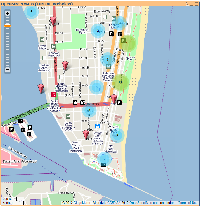
It uses the CloudMade.com Web API to display OpenStreetMap tiles. This is a first version with marker custers and automate positioning dependend from the data selection. You can zoom and drag inside the map.
The extension needs Lat/Long as dimension and a marker label as expression, as you can see in my demo app. It was tested with QV11.
Any feedback is very welcome!
- Ralf
Caution: I have to mention here that a demo API key is used in the extension. If you realy want to use this in a production environment you should get your own personal API key at: www.cloudmade.com
Update: Alexander and I have improved slightly. Now you can enter the API key in the properties pane and you can switch the markers clustering
- Mark as New
- Bookmark
- Subscribe
- Mute
- Subscribe to RSS Feed
- Permalink
- Report Inappropriate Content
Hi,
I'm trying to use this as well with my own data set from an SQL query, but I think I'm missing something.
From the original file, I have out commented all the scripts and added my own query that get's Countryname, Continent, Latitude and Longitude from our Country dimension table.
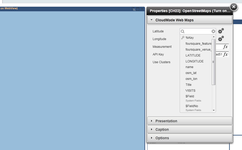
If I then right click on the "OpenStreetMap" object and look at the properties (see screen shot), I'd expect that I could select my own Latitude and Longitude columns for the Latitude and Longitude fields, but this doesn't seem to be the case. When I click on the drop-down arrow it's still only the "old" column names I see in the list. It looks like it hasn't recognized the new columns from my SQL query.
I'm new to qlikview, so it might be a very simple thing that I don't get, but hopefully someone can lead me on right track?
Regards
Steen
- Mark as New
- Bookmark
- Subscribe
- Mute
- Subscribe to RSS Feed
- Permalink
- Report Inappropriate Content
Hello, I have the same issue, but I don't see the amout of customers in one point, the map shows only a few of them not even 5 percent of all customers that should be showing, and it shows one customer per Point, if i show for instance postal Number it show all of them each in one point.
and is it possible to add another measurement to the map, cause I can't find any parameter that would allow to do so.
Thanks in advance for your help
- Mark as New
- Bookmark
- Subscribe
- Mute
- Subscribe to RSS Feed
- Permalink
- Report Inappropriate Content
Hi Ralf,
This is a nice extension. I'm working on adding Heat Maps to it. But it seems like there is almost -no- documentation on the web-maps-lite.js functions. I know there is a CM.Tiles.CloudMade.HeatMap function but haven't been able to get it to render just yet. Not sure what parameter it is expecting (a map, a layer, an api key). I am passing it the "map" object now and the map seems to be trying to do something but it just spins. It's like http://heatmap.cloudmade.com/ doesn't repsond. I have added another control to the extension already. But from spending a lot of time searching for documentation on this .js file (API) - I'm not finding anything. Do you have a link to CloudMade's documentation on this API by any chance? So far I'm seeing Google and Bing beat the pants off CloudMade in the form of documentation....
Thanks,
- Mark as New
- Bookmark
- Subscribe
- Mute
- Subscribe to RSS Feed
- Permalink
- Report Inappropriate Content
Hi Richard,
I haven't worked on it for a while and it seems Cloudmade website and products have changed a lot. So, maybe now ots better to switch over to the Leaflet API: Documentation - Leaflet - a JavaScript library for mobile-friendly maps
They also refer to it on their site..
- Ralf
- Mark as New
- Bookmark
- Subscribe
- Mute
- Subscribe to RSS Feed
- Permalink
- Report Inappropriate Content
Hi Ralf,
This solution looks very good. Can you let me know where to find the keep.qvd file, referred to from the script in your FoursquareNew.qvw document?
Are there any other data sources I would need to be able to customize the QVW for my own experimentation (I understand I will need a CloudMade key).
Thanks.
- Mark as New
- Bookmark
- Subscribe
- Mute
- Subscribe to RSS Feed
- Permalink
- Report Inappropriate Content
Hello Hiram,
here we go. Should not need other sources..
- Ralf
- Mark as New
- Bookmark
- Subscribe
- Mute
- Subscribe to RSS Feed
- Permalink
- Report Inappropriate Content
Hello,
I am trying to get a personal API key but i didnt find the way to in www.cloudmade.com
Could you help me please?
Regards,
Sami
- Mark as New
- Bookmark
- Subscribe
- Mute
- Subscribe to RSS Feed
- Permalink
- Report Inappropriate Content
Hi Sami,
I don't know. It's long time ago and they've changed their site..
Btw. I develop an OpenLayers mapping extension at the moment which is base also on OpenStreetMaps and would need no license. But it's still on early stage.
- Ralf
- Mark as New
- Bookmark
- Subscribe
- Mute
- Subscribe to RSS Feed
- Permalink
- Report Inappropriate Content
Hi Ralf,
Thank you for your answer and good luck for your new extension!
Sami
- Mark as New
- Bookmark
- Subscribe
- Mute
- Subscribe to RSS Feed
- Permalink
- Report Inappropriate Content
why my map don´t show in QlikView Server using browser?
I have step by step
to the server folder:
C:\ProgramData\QlikTech\QlikViewServer\Extensions\Objects\
In QMC checked Allow Extensions.
Any sugestion?