Unlock a world of possibilities! Login now and discover the exclusive benefits awaiting you.
- Qlik Community
- :
- All Forums
- :
- QlikView Integrations
- :
- Re: Google Maps - Marker
- Subscribe to RSS Feed
- Mark Topic as New
- Mark Topic as Read
- Float this Topic for Current User
- Bookmark
- Subscribe
- Mute
- Printer Friendly Page
- Mark as New
- Bookmark
- Subscribe
- Mute
- Subscribe to RSS Feed
- Permalink
- Report Inappropriate Content
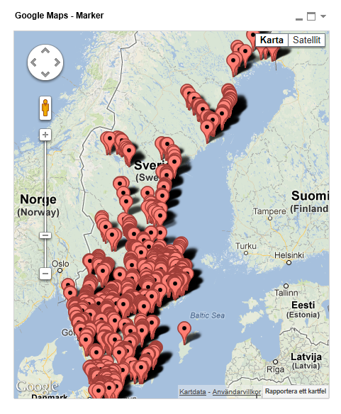
Google Maps - Marker
Google Maps Extension with Markers.
QlikTech takes no responsibility for any code and QlikTech Support Agreement does not cover issues with this extension.
Please review Googles license agreement before you put this into production.
Introduction
This is a QlikView extension object that integrates Google Maps Javascript API V3 into QlikView.
Load a set a coordinates into QlikView and visualize them together with this extension. This extension will plot every single data point as a marker on the map so if you have a large amount of markers please be aware that it might have some performance impact. If you are experiencing performance issues look into the cluster extension instead: http://community.qlik.com/message/325640
You can either use the extension 'as is' or use it as a base to further customize it to fit your needs.
Custom Markers
Added support for custom markers images. In the properties dialog you now have the option to specify a custom image.
You can either have a static image or let the expression evaluate one for you, for example:
=If(MyExpression > 1, 'http://image_for_true', 'http://image_for_false'). If you do not specify an url or enter an invalid one the extension will fallback to the standard marker.
Supported image extensions are bmp, jpg, jpeg, tiff, png and gif.
You can host the images through the qlikview webserver or through IIS.
If you build something awesome please share it with the community!
Live long and prosper.
- Mark as New
- Bookmark
- Subscribe
- Mute
- Subscribe to RSS Feed
- Permalink
- Report Inappropriate Content
You are right. I am running it with latest version of IE installed on my machine. Will this work fine with other web browsers once I upload this report to qvserver?
Arif
- Mark as New
- Bookmark
- Subscribe
- Mute
- Subscribe to RSS Feed
- Permalink
- Report Inappropriate Content
Yes the extension itself works with any browser, IE7+, FF, Chrome, Opera and Safari.
- Mark as New
- Bookmark
- Subscribe
- Mute
- Subscribe to RSS Feed
- Permalink
- Report Inappropriate Content
Hi Alexander,
Your maps are working really well for me and have helped me a lot. I had just one more question though. Is it possible to customize the tooltips for the markers/clusters? I need to show some detail when a user puts his mouse on a marker location
Arif
- Mark as New
- Bookmark
- Subscribe
- Mute
- Subscribe to RSS Feed
- Permalink
- Report Inappropriate Content
Have you tested this in Windows 8.1 and IE11? I cant see anything on my accesspoint, But i can easily see it inside Qlikview.
Or do you have any clue on why i cant see anything in my browser but in my qlikview?
- Mark as New
- Bookmark
- Subscribe
- Mute
- Subscribe to RSS Feed
- Permalink
- Report Inappropriate Content
IE11 support should be available with QV11.2 SR5
Kind Regards
Alexander Karlsson
- Mark as New
- Bookmark
- Subscribe
- Mute
- Subscribe to RSS Feed
- Permalink
- Report Inappropriate Content
Yep i fixed it 
- Mark as New
- Bookmark
- Subscribe
- Mute
- Subscribe to RSS Feed
- Permalink
- Report Inappropriate Content
HI
How many reports can we generate in dash board?
Thanks in advance
Gireesh
- Mark as New
- Bookmark
- Subscribe
- Mute
- Subscribe to RSS Feed
- Permalink
- Report Inappropriate Content
Hi Alexandar,
Can you please tell me if we there is any option for setting the layout and customizing the layer of the map object. I want the map to alway stay on the top of other object. Is this possible?
Arif
- Mark as New
- Bookmark
- Subscribe
- Mute
- Subscribe to RSS Feed
- Permalink
- Report Inappropriate Content
Hi Everybody:
I'm new with Qlikview and I'm trying to put a Map and put the markers using the Extension that Alex share here.
I have two questions.
1.- I want to change the colors of the markers depending on the expression I use, but, I don't know If adding the expression in the 'Popup Contents' field is the best way to do it?
2.- Once I put the expression there, I want to see the value of my expression when I put the mouse over the marker but what I see is the URL of the Marker. and In the example that Alex Share here, you can see the values.
Attached is the image. I hope somebody can help me.
Thanks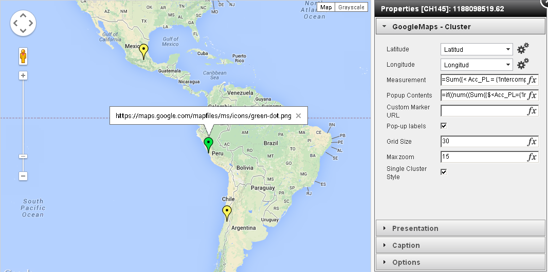
- Mark as New
- Bookmark
- Subscribe
- Mute
- Subscribe to RSS Feed
- Permalink
- Report Inappropriate Content
Hello Alex,
First of all, many thanks for developing this extension. It has helped me a lot. Now I have two questions here
1) I am trying to put a test custom icon by putting the following test icon URL in customer URL
http://findicons.com/files/icons/1733/msn_messenger_aqua/256/msn_online.png
However, the map is not showing it. Can you please tell me what is wrong with my method?
2) Is it possible to highlight the boundries of a certain town in the map?
Arif