Unlock a world of possibilities! Login now and discover the exclusive benefits awaiting you.
- Qlik Community
- :
- Forums
- :
- Analytics
- :
- New to Qlik Analytics
- :
- Re: Help with steps to create Map of Nigeria (Afri...
- Subscribe to RSS Feed
- Mark Topic as New
- Mark Topic as Read
- Float this Topic for Current User
- Bookmark
- Subscribe
- Mute
- Printer Friendly Page
- Mark as New
- Bookmark
- Subscribe
- Mute
- Subscribe to RSS Feed
- Permalink
- Report Inappropriate Content
Help with steps to create Map of Nigeria (Africa) to Interact with Sales Data
Hello,
Please can someone help me on steps to create a map of Nigeria that can interact with my Sales Data by Product and by Channel Dimension.
I really need an urgent answer please. Thank you
- Tags:
- qlik
- « Previous Replies
-
- 1
- 2
- Next Replies »
- Mark as New
- Bookmark
- Subscribe
- Mute
- Subscribe to RSS Feed
- Permalink
- Report Inappropriate Content
Ok, Thank you. I will be waiting for your response.
- Mark as New
- Bookmark
- Subscribe
- Mute
- Subscribe to RSS Feed
- Permalink
- Report Inappropriate Content
Hi Jennifer - please see the attached .kml file - I had to use a different approach to get the .kml file.
- Global Administrative Areas | Boundaries without limits
- Download
- Select Nigeria
- Select Google Earth (KMZ)
- OK
- Level 1
- Save the .kmz
- rename .kmz to .zip
- extract .zip to temp folder
- you will have .kml file
This file can then be used with this video to see how it is done:
Using the Maps Chart Object - Polygon Map - Part 2 - (video)
Note that the KML file has a field with the State names - that needs to be renamed to match the field State in the other file / data.
See the attached .qvf file too - copy to C:\Users\<user profile>\Documents\Qlik\Sense\Apps and restart Qlik Sense Desktop
Please mark the appropriate replies as helpful / correct so our team and other members know that your question(s) has been answered to your satisfaction.

Regards,
Mike Tarallo
Qlik
Mike Tarallo
Qlik
- Mark as New
- Bookmark
- Subscribe
- Mute
- Subscribe to RSS Feed
- Permalink
- Report Inappropriate Content
- Mark as New
- Bookmark
- Subscribe
- Mute
- Subscribe to RSS Feed
- Permalink
- Report Inappropriate Content
Hey Fred - happy to help.
Take care.
Mike
Mike Tarallo
Qlik
- Mark as New
- Bookmark
- Subscribe
- Mute
- Subscribe to RSS Feed
- Permalink
- Report Inappropriate Content
Hello Michael,
Thank you so much for your help. I really appreciate. I am almost there in getting what I need.
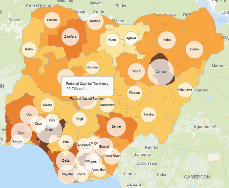
I noticed the map does not show the names of the state on looking at it. Meaning that one need to click on confirm its the state picked is correct.
My questions
1. Is it possible to have the state names displayed on the map just like this attachment
2. Is it possible that when one selects a state to view sales done and wants to click on another state the initial state selected will automatically unselect itself . Or do one need to unselect manually before selecting another.
I hope I am clear with my questions.
Hoping to hear from you soon.
Regards,
Ijeoyibo Onyebuagu
08067912344
Kind words can be short and easy to speak, but the echoes are endless.
Sent from Yahoo! Mail on Android
- Mark as New
- Bookmark
- Subscribe
- Mute
- Subscribe to RSS Feed
- Permalink
- Report Inappropriate Content
Hello Jennifer - great to hear. In answer to your questions:
1) - Providing labels, this is NOT possible using Qlik Sense directly, but it may be possible by editing the KML file and providing label syntax, however I tried it with your map using some of the KML style syntax but It does not display the text on the map - so it is assumed that it is not possible at this time. I will ask around.
2) You would need to click it again to un-select.
Please mark the appropriate replies as helpful / correct so our team and other members know that your question(s) has been answered to your satisfaction.
Please let me know if you have any more questions.
Regards
Mike
Mike Tarallo
Qlik
- Mark as New
- Bookmark
- Subscribe
- Mute
- Subscribe to RSS Feed
- Permalink
- Report Inappropriate Content
Hi Jennifer, to add more layers to the map such as text and symbols you would need a 3rd party map extension.
Here's how your data could look like with IdevioMaps, no kml import is necessary.
More info and live demos at QlikMarket:
http://market.qlik.com/ideviomaps-for-qlik-sense.html
Thanks,
Patric Nordström, Idevio
- Mark as New
- Bookmark
- Subscribe
- Mute
- Subscribe to RSS Feed
- Permalink
- Report Inappropriate Content
Hi Jennifer!
Were you able to resolve the state name showing?
Did you try reducing the opacity of the map?
Maybe that could help...
Regards,
Ayo
- « Previous Replies
-
- 1
- 2
- Next Replies »