Unlock a world of possibilities! Login now and discover the exclusive benefits awaiting you.
- Qlik Community
- :
- All Forums
- :
- QlikView App Dev
- :
- Re: Popup text in google maps charts
- Subscribe to RSS Feed
- Mark Topic as New
- Mark Topic as Read
- Float this Topic for Current User
- Bookmark
- Subscribe
- Mute
- Printer Friendly Page
- Mark as New
- Bookmark
- Subscribe
- Mute
- Subscribe to RSS Feed
- Permalink
- Report Inappropriate Content
Popup text in google maps charts
Hi experts,
i apologize if you read again this message: yesterday i posted it but (probably due to my fault) I don’t see in the forum.
I’m using google maps in qlikview and I’ve a problem related to pop up text.
In this sample(from qlik), we can see in the popup text:
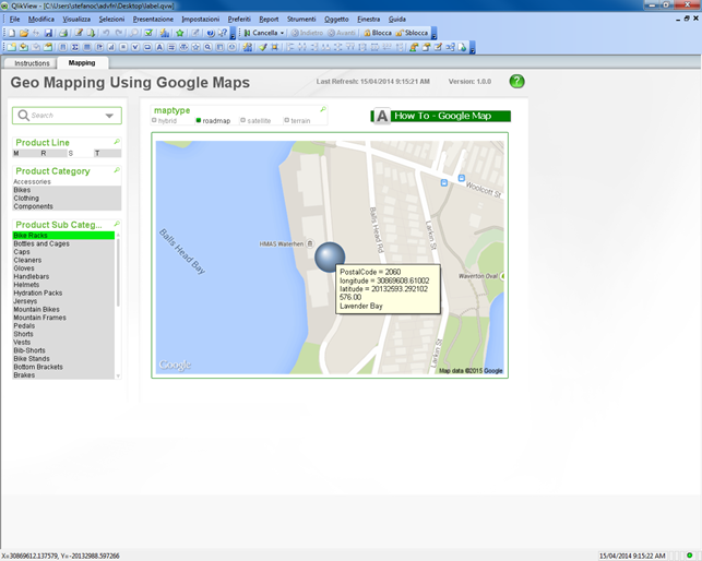
Postalcode (dimension)
Longitude (expression)
Latitude (expression)
Value (expression)
City (expression)
A Couple of questions:
1) How can I hide latitude and longitude information ? (I disabled text as popup for both values but apparently nothing changed)
2) Why longitude and latitude are displayed in the form:
Label = content
while Value and City only display the content ? how can i include/exclude labels ?
Many thanks in advance
Stefano
- « Previous Replies
-
- 1
- 2
- Next Replies »
- Mark as New
- Bookmark
- Subscribe
- Mute
- Subscribe to RSS Feed
- Permalink
- Report Inappropriate Content
u have to to do five things,
1. click on Presentation tab---UNCHECK Pop-up Lables check box from Lables in Chart.
2. Click on Expression tab-- click on ur expression "Value"-- CHECK the check box Text as Pop-up.
3. Click on Expression tab-- click on ur expression "Display Text"-- CHECK the check box Text as Pop-up.
4. Click on Expression tab-- click on ur expression "latitude"-- UNCHECK the check box Text as Pop-up.
5. Click on Expression tab-- click on ur expression "longitude"-- UNCHECK the check box Text as Pop-up.
seems to be ur little bit confused 
- Mark as New
- Bookmark
- Subscribe
- Mute
- Subscribe to RSS Feed
- Permalink
- Report Inappropriate Content
Hi Shiva,
it's exactly what i'm doing from yesterday.....unfortunately i see all 4 entities.
Even in the sample sent by Jonathan doesn't work on my pc
I' m downloading the last available release (sr10); hope it solve
Stefano
- Mark as New
- Bookmark
- Subscribe
- Mute
- Subscribe to RSS Feed
- Permalink
- Report Inappropriate Content
Johnathan,
i've just updated to SR10 and .....it works !!!!
than you VERY much for your assistance.
have a nice week end
Stefano
- Mark as New
- Bookmark
- Subscribe
- Mute
- Subscribe to RSS Feed
- Permalink
- Report Inappropriate Content
No worries man!
have a good weekend!
- Mark as New
- Bookmark
- Subscribe
- Mute
- Subscribe to RSS Feed
- Permalink
- Report Inappropriate Content
The Pop Up Lable option does not work as expected due to a bug in SR6, SR 7, SR 8 and SR 9
- Mark as New
- Bookmark
- Subscribe
- Mute
- Subscribe to RSS Feed
- Permalink
- Report Inappropriate Content
Hi ,
Can you create a sample qvw on how to use google map with some countries or states what so ever.
Actually I want to what are the different possibilities of how to use maps and what are the charts that support maps,
I saw only scatter chart but are there any charts to do this.
Thank You
Kiran Kumar
- Mark as New
- Bookmark
- Subscribe
- Mute
- Subscribe to RSS Feed
- Permalink
- Report Inappropriate Content
Hi Kiran,
One very good example is Qlikview Sample file "What's New in Qlikview 11.qvw".
This one shows locations region/country/state.
Maps can only be used on a Scatter Chart and text box.
Another way is to use extensions see Sample file Extension Examples".
I have attached an example file which fetches coordinates from the web based on City name(I believe this technique is called geo-coding). it also has a variable slider to zoom in/out. and a street view using a text box
- Mark as New
- Bookmark
- Subscribe
- Mute
- Subscribe to RSS Feed
- Permalink
- Report Inappropriate Content
Thanks for ur immediate response
- « Previous Replies
-
- 1
- 2
- Next Replies »