Unlock a world of possibilities! Login now and discover the exclusive benefits awaiting you.
- Qlik Community
- :
- All Forums
- :
- QlikView Integrations
- :
- Re: Google Maps - Marker
- Subscribe to RSS Feed
- Mark Topic as New
- Mark Topic as Read
- Float this Topic for Current User
- Bookmark
- Subscribe
- Mute
- Printer Friendly Page
- Mark as New
- Bookmark
- Subscribe
- Mute
- Subscribe to RSS Feed
- Permalink
- Report Inappropriate Content
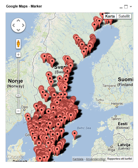
Google Maps - Marker
Google Maps Extension with Markers.
QlikTech takes no responsibility for any code and QlikTech Support Agreement does not cover issues with this extension.
Please review Googles license agreement before you put this into production.
Introduction
This is a QlikView extension object that integrates Google Maps Javascript API V3 into QlikView.
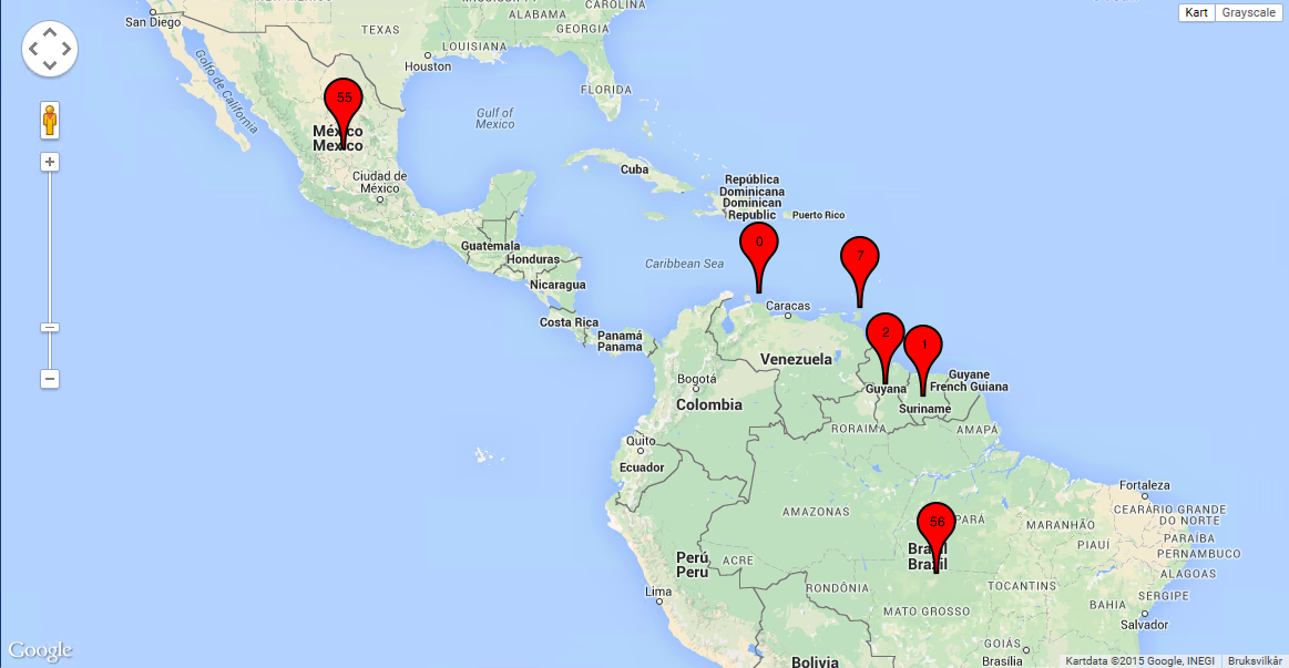
Load a set a coordinates into QlikView and visualize them together with this extension. This extension will plot every single data point as a marker on the map so if you have a large amount of markers please be aware that it might have some performance impact. If you are experiencing performance issues look into the cluster extension instead: http://community.qlik.com/message/325640
You can either use the extension 'as is' or use it as a base to further customize it to fit your needs.
Custom Markers
Added support for custom markers images. In the properties dialog you now have the option to specify a custom image.
You can either have a static image or let the expression evaluate one for you, for example:
=If(MyExpression > 1, 'http://image_for_true', 'http://image_for_false'). If you do not specify an url or enter an invalid one the extension will fallback to the standard marker.
Supported image extensions are bmp, jpg, jpeg, tiff, png and gif.
You can host the images through the qlikview webserver or through IIS.
If you build something awesome please share it with the community!
Live long and prosper.
- Mark as New
- Bookmark
- Subscribe
- Mute
- Subscribe to RSS Feed
- Permalink
- Report Inappropriate Content
Hi, I wonder how could insert two different markers , ie , one for employees and one for the place where they work, two different markers.
Thanks.
Regards
- Mark as New
- Bookmark
- Subscribe
- Mute
- Subscribe to RSS Feed
- Permalink
- Report Inappropriate Content
You sure can – You simply need to select your image from your QMEM source area and apply your If,then,else condition referencing the appropriate image to get the desired result.
If you want to post your key fields I can try to help you write the expression.
- Mark as New
- Bookmark
- Subscribe
- Mute
- Subscribe to RSS Feed
- Permalink
- Report Inappropriate Content
Thanks for your reply, I have two tables of users and other companies and would like to represent on the same map the positions of both tables separately, that is, when filtered by user the user's position and the position of the display company.
Thank you.
Regards.
- Mark as New
- Bookmark
- Subscribe
- Mute
- Subscribe to RSS Feed
- Permalink
- Report Inappropriate Content
Ok.
In this case, create a flag in your load script in each table.
'User' as type and 'company' as type. You may need to create a link table too to get all location information in one table with the flag delineation.
I hope this helps.
- Mark as New
- Bookmark
- Subscribe
- Mute
- Subscribe to RSS Feed
- Permalink
- Report Inappropriate Content
Ok, we already have realized the problem is that when you insert the field names of the coordinates (are four fields, ie, two fields forusers and two for now) only me two fields letyou insert and 4 from extension properties.
Thanks.
Regards.
- Mark as New
- Bookmark
- Subscribe
- Mute
- Subscribe to RSS Feed
- Permalink
- Report Inappropriate Content
Hello, I'm french so pardon me for my possible mistakes in english..
I loaded your version and I have a problem :
I created an Excel file were I put some adresses in france. My goal is to have a marker on each adress on my map.
The colums are :
Country, Adresse, Latitude, Longitude.
I searched on internet to convert my adresses on latitude and Longitude.
When I load my map, the markers doesn't work, Indeed, the marker who schould be on Paris is on Orlean.
Is there anything to do to make my markers work?
Thank you.
Raphael scavenius.
- Mark as New
- Bookmark
- Subscribe
- Mute
- Subscribe to RSS Feed
- Permalink
- Report Inappropriate Content
How to supress null values
- Mark as New
- Bookmark
- Subscribe
- Mute
- Subscribe to RSS Feed
- Permalink
- Report Inappropriate Content
Hi, this is really cool stuff!
I'm trying to use the extension to create dynamic markers, that pick up an expression. I'm trying to use the Custom Marker URL parameter, but it seems to me that it doesn't like the script on the following URL:
http://chart.apis.google.com/chart?chst=d_map_spin&chld=1|0|FF0000|12|_|3
The expression in the Custom Marker URL I'm trying to create is something along the following lines:
='http://chart.apis.google.com/chart?chst=d_map_spin&chld=1|0|FF0000|12|_|' & $(myParameter)
Is this because of the supported image extensions? Seeing as the API doesn't really return one of bmp, jpg, jpeg, tiff, png and gif, I'm assuming that the lack of a recognisable extension throws the code.
Thanks for the good work though!
Per Christian Nødtvedt
- Mark as New
- Bookmark
- Subscribe
- Mute
- Subscribe to RSS Feed
- Permalink
- Report Inappropriate Content
Hey Per Christian,
Yes that is correct, I arbitrarily hardcoded a check for certain file extensions.
In theory I would guess it would work with a dynamic image from google charts also.
In script.js you should be able to find the conditional check just allow any kind of image.
- Mark as New
- Bookmark
- Subscribe
- Mute
- Subscribe to RSS Feed
- Permalink
- Report Inappropriate Content
Thank you for the quick reply Alexander,
I brute forced the regular expression in the validation of the picture URL in script.js and changed it from:
var reg = /\.(gif|jpg|jpeg|tiff|png|bmp)$/;
to
var reg = /(.*chart\.apis\.google\.com.*)|(\.(gif|jpg|jpeg|tiff|png|bmp))$/;
That did the trick, by allowing google api urls in addition to the current list of file extensions, and now allows me to do stuff like the following to the Custom Marker URL:
='http://chart.apis.google.com/chart?chst=d_map_spin&chld=1|0|FF0000|12|_|' & $(myParameter)
and get this:
The next obvious candidate for modification is of course to use a qlikview function to generate a colour based on the parameter value to permit visual distinctions between the markers as well. This should be fairly straightforward, by using parameter expansion in the URL.
Thank you again for a useful extension.
Per Christian