Unlock a world of possibilities! Login now and discover the exclusive benefits awaiting you.
- Qlik Community
- :
- Forums
- :
- Analytics
- :
- New to Qlik Analytics
- :
- Re: Best way to include Map in an Qlik Sense file?
- Subscribe to RSS Feed
- Mark Topic as New
- Mark Topic as Read
- Float this Topic for Current User
- Bookmark
- Subscribe
- Mute
- Printer Friendly Page
- Mark as New
- Bookmark
- Subscribe
- Mute
- Subscribe to RSS Feed
- Permalink
- Report Inappropriate Content
Best way to include Map in an Qlik Sense file?
Hi All,
This post is in regards to using an KML file to load Map onto an Qlik Sense dashboard.
Although i was successful in loading an World Map from a KML file by mapping it using CountryName from my DB(SQL).
But, the outcome is rather slow and even consumes more than a minute only to load the map.
Could any one please suggest an alternate or best way on this approach.
TIA,
Best Regards.
- Tags:
- kmlmap
- « Previous Replies
- Next Replies »
Accepted Solutions
- Mark as New
- Bookmark
- Subscribe
- Mute
- Subscribe to RSS Feed
- Permalink
- Report Inappropriate Content
Hi Sai Kumar,
Refer to the Screen shots and the qvf file attached.


Best Regards,
Sangram Reddy.
- Mark as New
- Bookmark
- Subscribe
- Mute
- Subscribe to RSS Feed
- Permalink
- Report Inappropriate Content
- Mark as New
- Bookmark
- Subscribe
- Mute
- Subscribe to RSS Feed
- Permalink
- Report Inappropriate Content
Thanks for the quick response Ahlawat,
Is this extension free like the KML extension, and does this have an World Map add-in?
- Mark as New
- Bookmark
- Subscribe
- Mute
- Subscribe to RSS Feed
- Permalink
- Report Inappropriate Content
How big is the KML file ? It may have a lot more details than really required. Consider processing the file in something like qGIS to remove detail and reload the less granular KML into SENSE:
To reduce the complexity of a KML file, you can do this for free with qGIS: http://www.qgis.org/en/site/
- Load the KML file into qGIS
- Right-click on the layer you want to simplify select Zoom to Layer so that you can see the entire layer.
- In the menu bar, go to Vector -> Geometry tools -> Simplify geometries. This opens a window and your layer should be selected in the Input line or polygon layer drop down menu. If not, select it.

- Next, look for the Simplify tolerance field. This measurement is in degrees so you want to use a really small number. The default of 0.0001 is a good place to start.
- Check Save to new file and save it as a .shp file
- Check Add result to canvas to add the simplified layer into qGIS
- Once reduced a new window will tell you how many vertices were removed. It should have removed somewhere between 70 percent to 90 percent of the original vertices.

- Right-click the new layer and select Save As...
- Select Format: Keyhole Markup Language (KML) and save the layer as a new (reduced) KML fil
- Mark as New
- Bookmark
- Subscribe
- Mute
- Subscribe to RSS Feed
- Permalink
- Report Inappropriate Content
Hi Jonathan,
Thanks for the suggestion and sorry for the delayed response.
I'm basically trying to load an World Map from KML, could you please suggest on how to figure out the non-required stuff.
- Mark as New
- Bookmark
- Subscribe
- Mute
- Subscribe to RSS Feed
- Permalink
- Report Inappropriate Content
I have been watching your active help and response to lot other posts.
Could you please see if this is something i could be pulled put of.
TIA.
- Mark as New
- Bookmark
- Subscribe
- Mute
- Subscribe to RSS Feed
- Permalink
- Report Inappropriate Content
Hi SaiKumar,
The reason for the performance issue could be that you are trying to plot a kml file which has multitude number of polygons. As you might be having data only for a few countries in world map, I would suggest you to follow this.
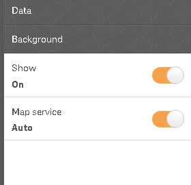
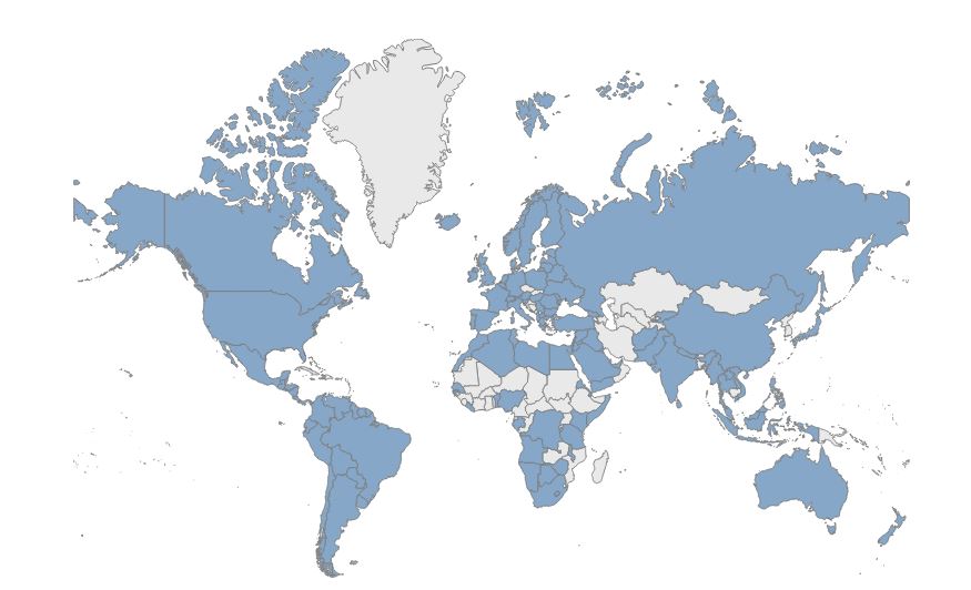
Just plot the polygons which have data or measures associated to it and make use of the background property in the properties panel.
And the output would be some thing like this:
Though you are not plotting the entire world map using the polygon data, you happen to visualize all the information required.
Hope this helps you resolve your issue.
Thanks,
Sangram
- Mark as New
- Bookmark
- Subscribe
- Mute
- Subscribe to RSS Feed
- Permalink
- Report Inappropriate Content
Hi Sangram,
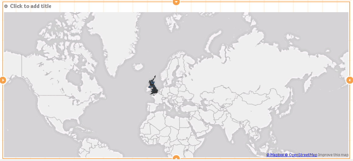
Thanks for the quick response. As in the image below i have only been considering countries which have presence in my data.
And also turning the background is making the map show up more then once.
- Mark as New
- Bookmark
- Subscribe
- Mute
- Subscribe to RSS Feed
- Permalink
- Report Inappropriate Content
My suggestion above was to decrease the precision of the polygons. That will reduce the files size considerably and allow it work faster in Qlik Sense.
I'm not clear if you followed the steps above or not. Did you follow them ? Or are you asking for alternatives ?
An alternative, which i think could be less effective, is as follows:
MainData:
Load
Country,
...
from <>
KML:
Load
Country,
<other KML Fields>
from <KML file>
where exists(Country,Country);
This would only load the country polygons from for the countries that exist in your main data sets. This will introduce holes in gaps in the map, but with the technique mentioned by Sangram you could fill those by turning on the map background.
- Mark as New
- Bookmark
- Subscribe
- Mute
- Subscribe to RSS Feed
- Permalink
- Report Inappropriate Content
Hi Sai Kumar,
Looks great!
Hope that helped you solve the issue.
Beast Regards,
Sangram Reddy.
- « Previous Replies
- Next Replies »