Unlock a world of possibilities! Login now and discover the exclusive benefits awaiting you.
- Qlik Community
- :
- Forums
- :
- Analytics
- :
- New to Qlik Analytics
- :
- Re: google map
- Subscribe to RSS Feed
- Mark Topic as New
- Mark Topic as Read
- Float this Topic for Current User
- Bookmark
- Subscribe
- Mute
- Printer Friendly Page
- Mark as New
- Bookmark
- Subscribe
- Mute
- Subscribe to RSS Feed
- Permalink
- Report Inappropriate Content
google map
hi all,
I want to use Map in the sense can some please help me as i tried some examples by extracting some latitudes and longitudes but was unable to get the map in the Sense.
can some one share with a simple example
- Mark as New
- Bookmark
- Subscribe
- Mute
- Subscribe to RSS Feed
- Permalink
- Report Inappropriate Content
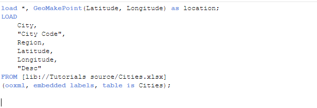
Hi naresh
load the data from the lib and make latitude and longitude as location before the load statement.
below is the example
!
- Mark as New
- Bookmark
- Subscribe
- Mute
- Subscribe to RSS Feed
- Permalink
- Report Inappropriate Content
Hi Naresh,
Use the load statement as above and add in an other field to your load.
GeoMakePoint(Latitude,Longitude) as [Map Point]
This field can be used to plot points in a map.
- Mark as New
- Bookmark
- Subscribe
- Mute
- Subscribe to RSS Feed
- Permalink
- Report Inappropriate Content
Agreed with Sangram, use GeoMakePoint() as script level, also see this:
Using the Maps Chart Object - Points Maps - Part 1 - (video)
Using Google Maps In Your Qlik Sense Applications – Colaberry Network
- Mark as New
- Bookmark
- Subscribe
- Mute
- Subscribe to RSS Feed
- Permalink
- Report Inappropriate Content
Hello Naresh,
The above suggestions from our community members are sufficient, please let us know how you do.
Please mark the appropriate replies as CORRECT / HELPFUL so our team and other members know that your question(s) has been answered to your satisfaction.
Regards,
Mike Tarallo
Qlik
Mike Tarallo
Qlik
- Mark as New
- Bookmark
- Subscribe
- Mute
- Subscribe to RSS Feed
- Permalink
- Report Inappropriate Content
thanks for the reply i vll try now above mentioned