Unlock a world of possibilities! Login now and discover the exclusive benefits awaiting you.
- Qlik Community
- :
- Forums
- :
- Analytics
- :
- App Development
- :
- Re: How to associate Dimensions to a point on a ma...
- Subscribe to RSS Feed
- Mark Topic as New
- Mark Topic as Read
- Float this Topic for Current User
- Bookmark
- Subscribe
- Mute
- Printer Friendly Page
- Mark as New
- Bookmark
- Subscribe
- Mute
- Subscribe to RSS Feed
- Permalink
- Report Inappropriate Content
How to associate Dimensions to a point on a map?
So I have a set of data, and I want to display the total sum of the dollars obligated by region. How do I associate each region with a specific point on the map. Ideally, the map would like something like this:
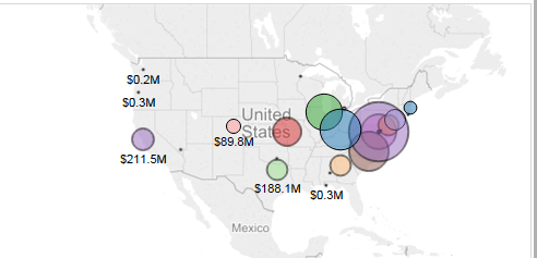
As you can see, it is totaling the amount obligated by each office which is associated with a specific dimension.
Your help is most appreciated
- Mark as New
- Bookmark
- Subscribe
- Mute
- Subscribe to RSS Feed
- Permalink
- Report Inappropriate Content
Hi Toufique,
You will be needing the Latitude and Longitude of every region(Your dimension here) and make use of the GeoMakePoint(Latitude,Longitude) as point to create a point .
Now you can plot the map the using this as the layer and the sales as the measure. You will end up with a map you need.
You can even use a polygon to have a boundary map.
Thanks and Regards,
Sangram Reddy.