Unlock a world of possibilities! Login now and discover the exclusive benefits awaiting you.
- Qlik Community
- :
- Blogs
- :
- Technical
- :
- Product Innovation
- :
- Qlik Geocoding ® - Street Addresses and Qlik GeoAn...
- Subscribe to RSS Feed
- Mark as New
- Mark as Read
- Bookmark
- Subscribe
- Printer Friendly Page
- Report Inappropriate Content
For most geo-related use cases, the highest level of needed detail is the town or postal code district. There are, however, certain use cases where one needs to also include street addresses. And for that, Qlik now offers Qlik Geocoding. Initially released this past April, Qlik Geocoding is an optional, add-on subscription service to Qlik GeoAnalytics Base and Qlik GeoAnalytics Enterprise Server that determines the coordinates of a street address or the other way around.
The service is provided through the Qlik GeoAnalytics Connector (for both QlikView and Qlik Sense) using the operations “AddressPointLookup” and “PointToAddressLookup”. “AddressPointLookup” is used for forward geocoding (given this address, what are the coordinates). “PointToAddressLookup” is used for reverse geocoding or converting coordinates to an address. This could be useful, for example, to convert GPS coordinates to a street location.
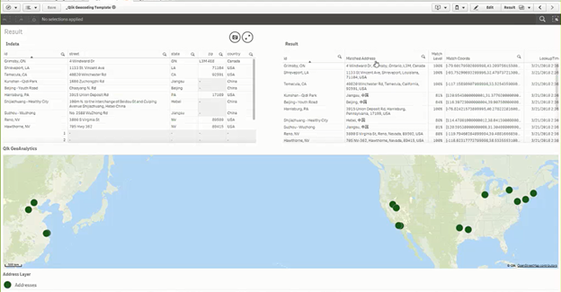
An example of forward geocoding can be seen in this screenshot. The original addresses are in the table on the left. The related coordinates that were returned by Qlik Geocoding are in the table on the right.

Qlik’s source of geocoding information is the Esri World Geocoding Service and, like any mapping source, the completeness and level of detail will vary by country. Countries with rich datasets should accurately return the correct house number. Countries with limited datasets may only be able to match to the street or region, not the address.
Qlik Geocoding is only offered as a hosted service and is subscription priced based on how many lookups are done each year. Because of this, we recommend that you store all completed look-up results locally for future reference. Thus, you only need to use Qlik Geocoding in the future for new addresses. This can significantly reduce the number of address lookups and thus minimize the cost of using Qlik Geocoding.
To learn more about our Qlik Geocoding service check out this video by our Mike Tarallo, which provides a brief presentation about the service and a more in depth how-to with some tips and tricks along the way. Mike has also provided some sample data and a Qlik Sense example as well for you to use within your Qlik Sense implementation. Also see his next video which covers the Line Layer and the use of the "Closest" operator with the Qlik GeoAnalytics Connector: Get Familiar with Qlik GeoAnalytics - The "Closest" Operator.
Resources mentioned in this video:
• https://help.qlik.com/en-US/geoanalytics/Content/Home.htm/
• Geocoding Template: https://bi.idevio.com/products/qlik-geocoding
More Qlik GeoAnalytics Videos and Blogs:
You must be a registered user to add a comment. If you've already registered, sign in. Otherwise, register and sign in.