Unlock a world of possibilities! Login now and discover the exclusive benefits awaiting you.
- Qlik Community
- :
- Forums
- :
- Analytics & AI
- :
- Products & Topics
- :
- App Development
- :
- Qlik Sense area map popup
- Subscribe to RSS Feed
- Mark Topic as New
- Mark Topic as Read
- Float this Topic for Current User
- Bookmark
- Subscribe
- Mute
- Printer Friendly Page
- Mark as New
- Bookmark
- Subscribe
- Mute
- Subscribe to RSS Feed
- Permalink
- Report Inappropriate Content
Qlik Sense area map popup
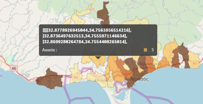
I am using a KML file to map areas using the standard Map object in June 2018 edition of Qlik Sense. My dimension is a simple calculated field (see "Assets" below). When I click/hover over an area I see the definition of the area instead of the name of the area.
Is there any way that I can show anything other than the area coordinates or at the very least to hide this set of coordinates and just show the Measure field in the popup?
Thanks in advance

Accepted Solutions
- Mark as New
- Bookmark
- Subscribe
- Mute
- Subscribe to RSS Feed
- Permalink
- Report Inappropriate Content
Hi Alexis,
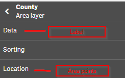
the label is the area points.
Try this:
add the column with the label as area layer, then at the properties of the layer add the points to Location.
G.
- Mark as New
- Bookmark
- Subscribe
- Mute
- Subscribe to RSS Feed
- Permalink
- Report Inappropriate Content
Hi Alexis,
the label is the area points.
Try this:
add the column with the label as area layer, then at the properties of the layer add the points to Location.
G.
- Mark as New
- Bookmark
- Subscribe
- Mute
- Subscribe to RSS Feed
- Permalink
- Report Inappropriate Content
Perfect - that is exactly what I wanted = thank you very much Gabor
- Mark as New
- Bookmark
- Subscribe
- Mute
- Subscribe to RSS Feed
- Permalink
- Report Inappropriate Content
I was also having the same issue. It worked perfectly.
Thank you undergrider.