Unlock a world of possibilities! Login now and discover the exclusive benefits awaiting you.
- Qlik Community
- :
- Forums
- :
- Analytics
- :
- New to Qlik Analytics
- :
- Re: Calculated Dimension on Qlik Sense Map Objects...
- Subscribe to RSS Feed
- Mark Topic as New
- Mark Topic as Read
- Float this Topic for Current User
- Bookmark
- Subscribe
- Mute
- Printer Friendly Page
- Mark as New
- Bookmark
- Subscribe
- Mute
- Subscribe to RSS Feed
- Permalink
- Report Inappropriate Content
Calculated Dimension on Qlik Sense Map Objects?
It seems that when I create a calculated dimension, it does not come up as an option when I want to add it as a point layer to a map object in sense. Only uncalculated fields or dimensions show up as available options. Is that the case or am I missing something?
Thanks
- « Previous Replies
-
- 1
- 2
- Next Replies »
- Mark as New
- Bookmark
- Subscribe
- Mute
- Subscribe to RSS Feed
- Permalink
- Report Inappropriate Content
Hi,
You can use Calculated Dimensions as Point Layer in a Map. It works totally fine.
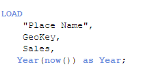
Here Year is a simple calculated field.
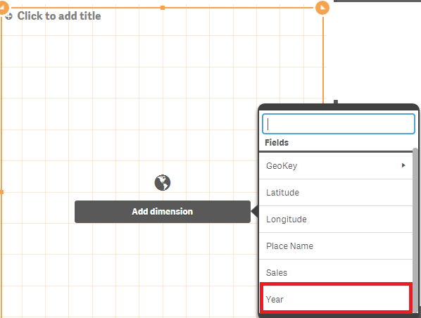
And it appears in your Point Layer Option.
Regards,
Rohan
- Mark as New
- Bookmark
- Subscribe
- Mute
- Subscribe to RSS Feed
- Permalink
- Report Inappropriate Content
Hi notbuyingit,
first du you have GeoMap.Latitude, GeoMap.Longitude for the place u want to add a value to?
Here is a vid that helped me creating my first pointmap in Qlik Sense
Using the Maps Chart Object - Points Maps - Part 1 - (video)
- Mark as New
- Bookmark
- Subscribe
- Mute
- Subscribe to RSS Feed
- Permalink
- Report Inappropriate Content
It seems to be the case. Can you move calculation to the data load script, so that your dimension can be simply derived from a field?
- Mark as New
- Bookmark
- Subscribe
- Mute
- Subscribe to RSS Feed
- Permalink
- Report Inappropriate Content
Hi Alex,
i did the calculation in the formular field so u dont need to do all in script.
but i agreee its a lot easier in the app to manage.
- Mark as New
- Bookmark
- Subscribe
- Mute
- Subscribe to RSS Feed
- Permalink
- Report Inappropriate Content
Eric,
I meant to respond to notbuyingit's original post, not your comment. Sorry about the confusion.
Alex !
- Mark as New
- Bookmark
- Subscribe
- Mute
- Subscribe to RSS Feed
- Permalink
- Report Inappropriate Content
np, it was just an add of opinion to push ur comment.
- Mark as New
- Bookmark
- Subscribe
- Mute
- Subscribe to RSS Feed
- Permalink
- Report Inappropriate Content
Hi Eric,
Thanks for the reply! I'm very familiar with this video and already have my maps up and running with the appropriate geo-coordinates included. My main question has to do with what happens when you create a calculated dimension not in the load script, but within the app, saved as dimension, and wish to use that calculated dimension as the point layer. The map object doesn't seem to recognize any dimensions that are calculated in the app, only those that are pre-calculated in the load script. Does this clarify?
Thanks again!
- Mark as New
- Bookmark
- Subscribe
- Mute
- Subscribe to RSS Feed
- Permalink
- Report Inappropriate Content
Thanks Alex! Glad you confirmed my issue. I had thought about creating in the load script as a backup, but one of the reasons that was not my first choice is because the logic I'm using in the calculated dimension, relies on 5 or more table joins that is already done in the app, whereas I would need to create that long query statement within the load script.
It's possible to do, but with the potential that we may want to create several calculated dimensions on the fly, and the fact that you can create and save calculated dimensions within the app to be used in charts and table objects, etc., I thought it would be great to leverage those dimensions in the map object as well.
Thanks again and let me know if you can think of any thing else that could help.
- Mark as New
- Bookmark
- Subscribe
- Mute
- Subscribe to RSS Feed
- Permalink
- Report Inappropriate Content
Thanks for the reply Rohan. I'm looking for a way to use calculated dimensions without generating them in the load script first.
- « Previous Replies
-
- 1
- 2
- Next Replies »