Unlock a world of possibilities! Login now and discover the exclusive benefits awaiting you.
- Qlik Community
- :
- Forums
- :
- Analytics
- :
- New to Qlik Analytics
- :
- Re: Qlik Sense Mapping and County KML
- Subscribe to RSS Feed
- Mark Topic as New
- Mark Topic as Read
- Float this Topic for Current User
- Bookmark
- Subscribe
- Mute
- Printer Friendly Page
- Mark as New
- Bookmark
- Subscribe
- Mute
- Subscribe to RSS Feed
- Permalink
- Report Inappropriate Content
Qlik Sense Mapping and County KML
I am trying to load County KML file Cartographic Boundary KML Files - Counties - Geography - U.S. Census Bureau to Sense and there is a problem with it.
If you just drop that KML file to Qlik Sense, the county is identified by its name:
this is a problem because there duplicated by county name. It is not a Qlik Sense issue - census people really should have been used FIPS code instead but the question I have for you guys if it is possible somehow to use other attributes from KML file. They do have FIPS code in there, but it is rather recorded under GEOID note not NAME:
<SimpleData name="GEOID">12095</SimpleData>
<SimpleData name="NAME">Orange</SimpleData>
- « Previous Replies
-
- 1
- 2
- Next Replies »
Accepted Solutions
- Mark as New
- Bookmark
- Subscribe
- Mute
- Subscribe to RSS Feed
- Permalink
- Report Inappropriate Content
Hi Boris,
I have solved the problem using QGIS. http://www.qgis.org/en/site/
The solution is:
- Open the boundary file in QGIS (in my case I opened a MapInfo Tab file. You can open many formats.)
- Right click on boundary and "Save As"
- Choose KML as the format you want to save us
- Under data source options type in the the field you want to map to the name field
- Press OK
When I import this into Sense I now have the key field stored in the name field which makes it easy to join to the data model.
Regards,
Tim
- Mark as New
- Bookmark
- Subscribe
- Mute
- Subscribe to RSS Feed
- Permalink
- Report Inappropriate Content
I believe you can use any field as a key, as long as you can link it back to your fact data. So if you have FIPS code linked to your facts, then yes.
-Rob
- Mark as New
- Bookmark
- Subscribe
- Mute
- Subscribe to RSS Feed
- Permalink
- Report Inappropriate Content
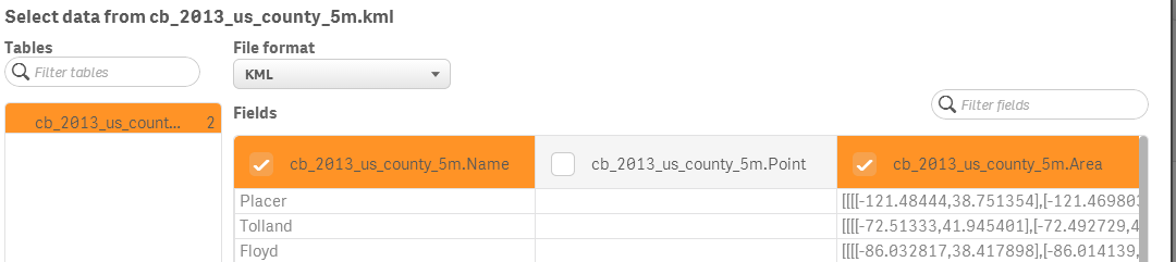
unfortunately if you use KML format, Qlik Sense only shows/loads three fields - Name, Point and Area. Point one is always empty. It does not show/load any other attributes from KML file
- Mark as New
- Bookmark
- Subscribe
- Mute
- Subscribe to RSS Feed
- Permalink
- Report Inappropriate Content
Boris, I have run into this issue also, and am wondering whether you found a solution.
- Mark as New
- Bookmark
- Subscribe
- Mute
- Subscribe to RSS Feed
- Permalink
- Report Inappropriate Content
I did not find an easy way unfortunately.
I think i almost got it work by replacing the Name attribute with CountyState code - I wrote regex to do that but then I gave up - it was something I did for proof-of-concept and it did not go that well.
Another option i was entertaining is to use spatial tools and rebuild KML file itself.
- Mark as New
- Bookmark
- Subscribe
- Mute
- Subscribe to RSS Feed
- Permalink
- Report Inappropriate Content
Hi Boris,
I have solved the problem using QGIS. http://www.qgis.org/en/site/
The solution is:
- Open the boundary file in QGIS (in my case I opened a MapInfo Tab file. You can open many formats.)
- Right click on boundary and "Save As"
- Choose KML as the format you want to save us
- Under data source options type in the the field you want to map to the name field
- Press OK
When I import this into Sense I now have the key field stored in the name field which makes it easy to join to the data model.
Regards,
Tim
- Mark as New
- Bookmark
- Subscribe
- Mute
- Subscribe to RSS Feed
- Permalink
- Report Inappropriate Content
awesome, thanks for sharing your workaround, Tim!
- Mark as New
- Bookmark
- Subscribe
- Mute
- Subscribe to RSS Feed
- Permalink
- Report Inappropriate Content
No worries, Boris 
I noticed this qlik branch project yesterday which you might be interested in. It looks quite good compared to the default sense maps. GoogleMapsAPIv3Toolkit-QS
- Mark as New
- Bookmark
- Subscribe
- Mute
- Subscribe to RSS Feed
- Permalink
- Report Inappropriate Content
interesting project but unfortunately google maps API would be off limit for most commercial applications unless you get a full license (starts at $10,000 annually). at some point i did an extensive research and contacted google team to clarify license agreement. in a nutshell, if you work for someone and use google map API and that application is not accessible to public (not only employees of your company but the entire world), then you will be violating license agreement. Same thing with Microsoft. The only truly free solution i found back then was MapQuest open API which worked great for us. so keep this in mind
- Mark as New
- Bookmark
- Subscribe
- Mute
- Subscribe to RSS Feed
- Permalink
- Report Inappropriate Content
Hi Tim,
Can you please explain these steps in bit detail if possible or provide some link to perform these steps.
I too want a kml file along with Geo ID (since few Counties are with same name and different Geo IDs and they're meshing things up).
Regards,
Hardik
- « Previous Replies
-
- 1
- 2
- Next Replies »