Unlock a world of possibilities! Login now and discover the exclusive benefits awaiting you.
- Qlik Community
- :
- Forums
- :
- Analytics
- :
- New to Qlik Analytics
- :
- create map
- Subscribe to RSS Feed
- Mark Topic as New
- Mark Topic as Read
- Float this Topic for Current User
- Bookmark
- Subscribe
- Mute
- Printer Friendly Page
- Mark as New
- Bookmark
- Subscribe
- Mute
- Subscribe to RSS Feed
- Permalink
- Report Inappropriate Content
create map
Hi to all
I want to have map in my app that show different color for each region like demo exist in this demo
how could use map?any extension is needed?
tanks
Accepted Solutions
- Mark as New
- Bookmark
- Subscribe
- Mute
- Subscribe to RSS Feed
- Permalink
- Report Inappropriate Content
Hi Hossein,
Weird, I responded to you early this morning EST around 6AM or so. I believe that the discussion was branched over to a new forum in the QlikView area so we could request a copy of a new Iran map to see if others could help us. The thread is over here with my response to you:
You should have gotten an email notification with my message to you.
Sorry for the confusion.
Mike
Mike Tarallo
Qlik
- Mark as New
- Bookmark
- Subscribe
- Mute
- Subscribe to RSS Feed
- Permalink
- Report Inappropriate Content
This is an Demo App for QlikView Application, if you like this in QlikSense, have a look at this video Video Link : 2031
- Mark as New
- Bookmark
- Subscribe
- Mute
- Subscribe to RSS Feed
- Permalink
- Report Inappropriate Content
Hi Hossein,
Currently the Beta Map object, supports points and polygons. With polygons, each state by default, can be colored - if used as the area layer and color by dimension is selected. Let me see if I can create a quick example that would work for regional areas, I have an idea and will see if I can get a sample working for you.
Mike
Mike Tarallo
Qlik
- Mark as New
- Bookmark
- Subscribe
- Mute
- Subscribe to RSS Feed
- Permalink
- Report Inappropriate Content
Hi Hossein,
This Map object is in Beta and will improve over future releases.
See the video Daniel posted to learn more about this object:
See attached sample in this post.
Copy to C:\Users\<user profile id>\Documents\Qlik\Sense\Apps
Open MapRegionsTest
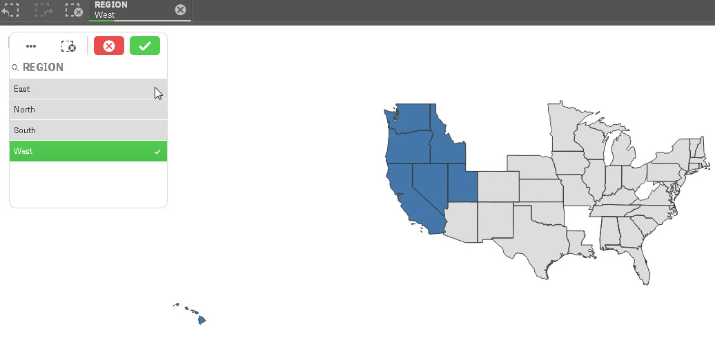
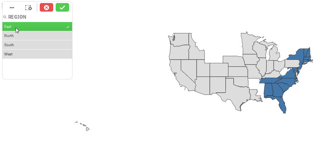
If your "REGIONAL" data is associated with your "STATE" data - you would use the "REGIONAL" dimension as your area layer - the corresponding "STATE" data will then color code appropriately for that region.
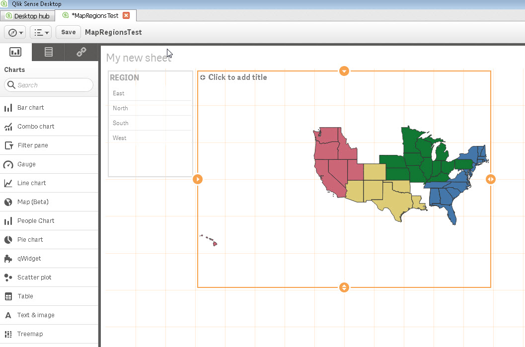
I have a field Region with values (East, North, South, West) and a field State (NY,CA, etc) - states are related to Regions via a common key in my data set. I used Region as the area layer.
Hope this helps
Mike
Mike Tarallo
Qlik
- Mark as New
- Bookmark
- Subscribe
- Mute
- Subscribe to RSS Feed
- Permalink
- Report Inappropriate Content
Attached is a world regional example using CountryISOCode as the area layer - colored by dimension.

Mike Tarallo
Qlik
- Mark as New
- Bookmark
- Subscribe
- Mute
- Subscribe to RSS Feed
- Permalink
- Report Inappropriate Content
Hi Hossein,
Weird, I responded to you early this morning EST around 6AM or so. I believe that the discussion was branched over to a new forum in the QlikView area so we could request a copy of a new Iran map to see if others could help us. The thread is over here with my response to you:
You should have gotten an email notification with my message to you.
Sorry for the confusion.
Mike
Mike Tarallo
Qlik
- Mark as New
- Bookmark
- Subscribe
- Mute
- Subscribe to RSS Feed
- Permalink
- Report Inappropriate Content
Hi Michael
you right I found it branched so deleted my previous reply
you dont know how much you help me with sending svg of IRAN and sample of svgreader extension.
sorry about bad english because english is not my mother tongue.
- Mark as New
- Bookmark
- Subscribe
- Mute
- Subscribe to RSS Feed
- Permalink
- Report Inappropriate Content
Hi Hossein,
Happy to have helped 
BTW - your English is better than any other second language that I can speak,  so bravo and very impressive. We were able to communicate together and get what you needed.
Regards and Stay well.
Mike T
Qlik
Mike Tarallo
Qlik
- Mark as New
- Bookmark
- Subscribe
- Mute
- Subscribe to RSS Feed
- Permalink
- Report Inappropriate Content
You responses were so impressive and helpful
thank you.
I sent you friends request I will be grateful if you accept
Best Regards