Unlock a world of possibilities! Login now and discover the exclusive benefits awaiting you.
- Qlik Community
- :
- All Forums
- :
- QlikView App Dev
- :
- How to add a shape file in GeoQlik?
- Subscribe to RSS Feed
- Mark Topic as New
- Mark Topic as Read
- Float this Topic for Current User
- Bookmark
- Subscribe
- Mute
- Printer Friendly Page
- Mark as New
- Bookmark
- Subscribe
- Mute
- Subscribe to RSS Feed
- Permalink
- Report Inappropriate Content
How to add a shape file in GeoQlik?
Hello All,
I am new to Qlikview and GeoQlik.Currently , I have added Geoqlik extension in Qlikview and added it to one qvw document.
I have a shape file with me and i would like to plot it or get it displayed on the geoqlik map(basemap).
Could somebody help me with a sample document or a sample file on the steps to be done for this(or how to add shape file to geoqlik)?
Also , if there is any online document available listing the steps (for adding shape file on geoqlik) map?
Thanks in advance.
~Nishant.
- Mark as New
- Bookmark
- Subscribe
- Mute
- Subscribe to RSS Feed
- Permalink
- Report Inappropriate Content
any help guys for this?
- Mark as New
- Bookmark
- Subscribe
- Mute
- Subscribe to RSS Feed
- Permalink
- Report Inappropriate Content
Hi,
Have you solved this issue ?
- Mark as New
- Bookmark
- Subscribe
- Mute
- Subscribe to RSS Feed
- Permalink
- Report Inappropriate Content
Hi Pablo,
Assuming that if you have not already found out, the trial version of the GeoQlik extension provides only 3 cartographic layers. You will need a licensed version to use your custom shape files. More of that is explained here GeoQlik Custom Polygon Coordinate (Shape File)
Regards,
Pritam
- Mark as New
- Bookmark
- Subscribe
- Mute
- Subscribe to RSS Feed
- Permalink
- Report Inappropriate Content
Hi Pritam,
Do you know whether the GeoQlik support data from SQL Server?
If GeoQlik can support data from SQL Server, will it support data type such as- Spatial Data?
Rgds,
Jim
- Mark as New
- Bookmark
- Subscribe
- Mute
- Subscribe to RSS Feed
- Permalink
- Report Inappropriate Content
Hi Jim,
Interesting. I have not been able to look at GeoQlik further; it's been a while since I last used it. Anyways, I will check that out and let you know.
Pritam
Sent from Outlook Mobile
- Mark as New
- Bookmark
- Subscribe
- Mute
- Subscribe to RSS Feed
- Permalink
- Report Inappropriate Content
Hi Jim,
As answered in another post, GeoQlik connects to Shapefiles, but not only.
It also connects to Oracle Locator/Spatial, ESRI ArcSDE, PostGIS, MapInfo and CSV (lat/long).
You can even use lat/long directly loaded in your dataset, so any spatial data points you have in SQL Server can be used if you connect it directly from your app.
Should you have any further questions please do let us know (contact@geoqlik.com),
Kind regards,
Cyril
- Mark as New
- Bookmark
- Subscribe
- Mute
- Subscribe to RSS Feed
- Permalink
- Report Inappropriate Content
Morning Cryil,
hope you sleep well.
I have a scenario as such - user uses MapInfo - converted .shape file to SQL Server Spatial Data Geometry Data Type.
So that particular column(Data Geometry Data Type) , that has been converted , stored a line as such " A8492ODA123" , can this data type(Spatial Geometry data) able to read in GeoQlik ?
Rgds.
Jim
- Mark as New
- Bookmark
- Subscribe
- Mute
- Subscribe to RSS Feed
- Permalink
- Report Inappropriate Content
Hello Cyril,
To add on, can these 2 data type(geometry, geography) read in GeoQlik?
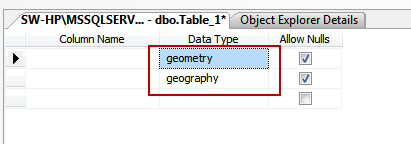
Rgd,
Jim
- Mark as New
- Bookmark
- Subscribe
- Mute
- Subscribe to RSS Feed
- Permalink
- Report Inappropriate Content
Hi Jim,
As answered previously, GeoQlik connects to MapInfo files as well as to Oracle Locator/Spatial, ESRI ArcSDE, PostGIS, Shapefiles and CSV (lat/long).
So you can use your MapInfo files. It is even possible to automatically reload files sources as to update the geometries should the files be modified.
You can even use lat/long directly loaded in your dataset, so any spatial data points you have in SQL Server can be used if you connect it directly from your app. In this case, you would be loading lat/long coordinates in your dataset to display points (not lines or polygons).
Should you have any further questions please do let us know (contact@geoqlik.com),
Kind regards,
Cyril