Announcements
Qlik Connect 2024! Seize endless possibilities! LEARN MORE
Alexander_Thor
Employee
Employee

You wake up in the morning and head down to the living room; faintly you hear a lingering “hohoho” from the chimney. Santa was here – and he left us something wonderful!


Santa is early this year, not only did he bring us a new and shiny service release for QlikView he also included a free to use mapping extension!

When you install the latest version of QlikView, http://www.qlik.com/download/, we now ship an Example Extension Object that makes use of OpenLayers and MapQuest.

So how do I make use of this sweet nectar you say?
Let me take you on a journey and explore some mapping possibilities!

  1. Head out and install the latest version of QlikView, make sure you install the examples.
  2. Navigate to C:\Program Files\QlikView\Examples\Extensions and double click the “Extensions Examples.qar” file. This will install all of the extension examples.
  3. Open the QlikView “Extension Examples that you can find in C:\Program Files\QlikView\Examples\Documents\
  4. In the Mapping tabs you will find examples on how to plot either dots/points, lines or polygons.

map.png

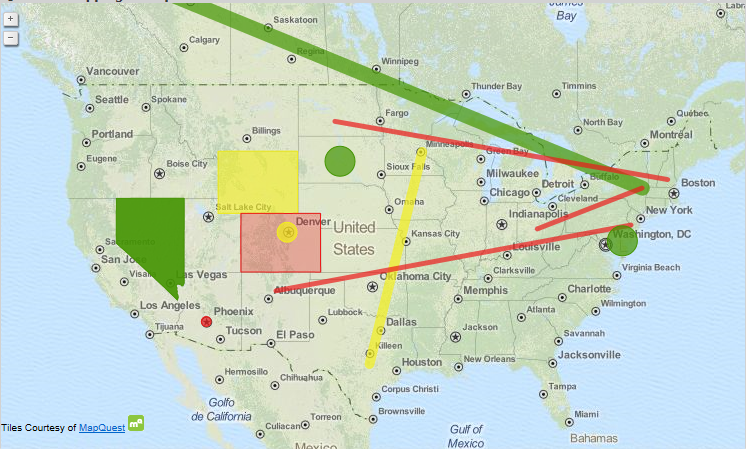
Attached to this post you will also find a dataset and an app that contains all of the high speed cameras in Sweden with corresponding latitude and longitude points if you want to play around with the extension, make sure you install the extension first, on your own.

Keep on Qliking!

Keep in mind

Extensions are generally built upon web technologies such as HTML and JavaScript and for QlikView to be able to render these objects on the screen you will need to run QlikView Desktop with WebView mode enabled or access the document through the AJAX-client over AccessPoint. The IE-plugin does not support extensions.

Disclaimer

The QlikView Mapping Example Extension can be configured to use many different map tile sources.

Each map tiles source has its own terms and conditions and the user assume all responsibility for the selection of a source for map tiles and for compliance with the terms and conditions of the selected source. Any and all liability associated with the selection of a tile source and the compliance with the terms and conditions of the selected source is hereby disclaimed.

24 Comments
phaneendra_kunc
Partner - Specialist III

Will this extension supported by qliktech, if there are any issues?

0 Likes
1,915 Views
Alexander_Thor
Employee
Employee

Examples are provided 'as is' and are not covered by the maintenance agreement.
With that said - there is basically three things that could potentially break (probably more but trying to illustrate a point here.

  1. JavaScript errors caused by a bug in your browsers javascript vm. Out of our control.
  2. Data quality issues - your data set is not 100% accurate causing the extension to show faulty data.
  3. Map tiles - QT does not own the map data. In this case it's OpenStreetMap tiles provided through Mapquest. OSM is a great open source project which I encourage everyone to check out however if for example a small river is missing from the map it's hard for us to 'own that problem' which saying we support this extension would imply.

If however QlikView has a bug that would affect extensions causing all/any/some extensions to fail then yes that would be covered under the maintenance agreement as the JS API is part of the product.

tl;dr - No. But most likely you won't experience any problems and if you do it's likely that error is supported as part of the API.

0 Likes
1,915 Views
Anonymous
Not applicable

Alexander

Looks very promising.

Having just looked on the web, both OpenLayers and MapQuest appear to free.  So is this ok licence wise to just use this or does one need to purchase additional 3rd party licensing for Business use on an internal local network ?

[Obviously one would need QlikView licensing sorted]

Best Regards,     Bill

0 Likes
1,915 Views
Alexander_Thor
Employee
Employee

Hi Bill,

No third party licenses has to be purchased if you are using the OpenLayers and MapQuest tiles.

MapQuest appreciates any heads up if you would drive an enormous amount of traffic in their direction, 4000 tiles/second over a sustained period of time.

You do have the option to change the map tiles provider to something else then it's up to you make sure you are following that providers ToC.

0 Likes
1,915 Views
Not applicable

Nice

0 Likes
1,915 Views
jpapador
Partner - Specialist

Anyone having trouble getting the event calendar to work on the server.  The object shows up on the list as an extension object but when you add it to the document QV adds a plain calendar object.  Using the AJAX client on both IE8 and FF.  Works fine if you just use the desktop in web view tho.

0 Likes
1,915 Views
valerio_fatatis
Partner - Creator
Partner - Creator

Great update for direct select metodology and function very efficent.

The new map extention is new jump.

0 Likes
1,698 Views
Not applicable

Very nice . Does the object support multipolygons?

0 Likes
1,698 Views
Anonymous
Not applicable

Hi everyone. You can also consider GeoQlik for enhanced mapping features. GeoQlik is provided by Business Geografic, QlikView's first mapping partner and premiere Qonnections 2013 sponsor.

GeoQlik_v11.7_flowmaps_black_border.png

geoqlik_v11_heatmap_border.png

More information on http://www.geoqlik.com/.

0 Likes
1,698 Views
Anonymous
Not applicable

Hi Alexander,

very nice but..

any chance the extension can be updated with the option of changing the tooltip?

right now it simply says example tooltip which is not that useful.

thanks

Magnus

1,698 Views