Unlock a world of possibilities! Login now and discover the exclusive benefits awaiting you.
- Qlik Community
- :
- All Forums
- :
- GeoAnalytics
- :
- GeoAnalytics Area Layer labels not in right place
- Subscribe to RSS Feed
- Mark Topic as New
- Mark Topic as Read
- Float this Topic for Current User
- Bookmark
- Subscribe
- Mute
- Printer Friendly Page
- Mark as New
- Bookmark
- Subscribe
- Mute
- Subscribe to RSS Feed
- Permalink
- Report Inappropriate Content
GeoAnalytics Area Layer labels not in right place
Hi all
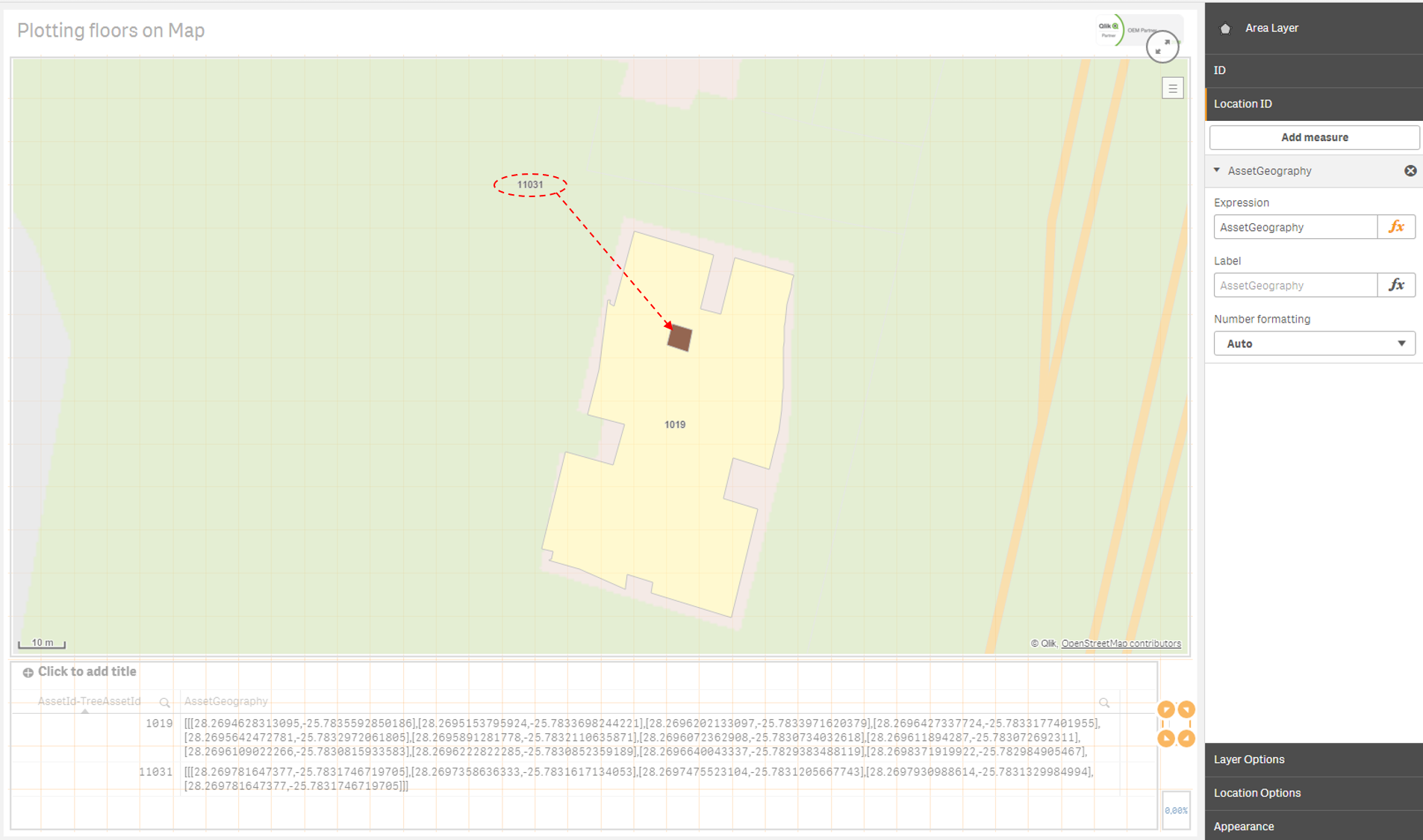
I have a Qlik Sense App in which I plot the GeoJSON coordinates of a floorplan on a map using an Area Layer on top of a GeoAnalytics Map. This works brilliantly, however, some of the labels are in the wrong place. The polygons are plotted in the right areas, it just seems like the center point used for the label is not in the right place. I have added a screenshot with two of my rooms/assets as well as a table with their GeoJSON coordinates. 1019 is in the right place, but 11031 is not as it should be on top of the room. The areas which I am plotting are quite small and the screenshot below is the furthest that I can zoom in so I am not sure if that is causing the problem.
Please let me know if anyone has any ideas.
Accepted Solutions
- Mark as New
- Bookmark
- Subscribe
- Mute
- Subscribe to RSS Feed
- Permalink
- Report Inappropriate Content
Hi,
Yes, I can confirm, it was a bug and the fix is coming in Nov of QGA.
Not sure if I understood but you can load external shapefiles:
Loading Esri shapefiles in Qlik GeoAnalytics
Setting the map to "Empty" will remove the basemap.
Thanks,
Patric
- Mark as New
- Bookmark
- Subscribe
- Mute
- Subscribe to RSS Feed
- Permalink
- Report Inappropriate Content
Hi,
Seems like a bug, meanwhile as workaround
- Make a point layer
- Use =GeoGetPolygonCenter(AssetGeometry) as Location
- Make the point very small/same color
- Set the label on the point
Thanks,
Patric
- Mark as New
- Bookmark
- Subscribe
- Mute
- Subscribe to RSS Feed
- Permalink
- Report Inappropriate Content
Hi Patric
Thank you for the feedback. The problem is that I want to use the custom info bubble as Mike Tarallo discusses in this video: Qlik GeoAnalytics - Custom Info Bubble - YouTube. In other words, I want to have both the label and the info bubble displaying in the right place (the info bubble's placement seems to be just above the label). I was able to do this by performing the steps in Mike's video on the point layer as you suggested, but then the info bubble only appears when I hover over the exact center point of the room and not when I hover over the room. For now that is acceptable while Qlik fixes the bug as I can just make the points a little bigger. I have created some new (bigger) polygons as a test and everything seems to work there. Is there a way to add a custom base map like shape file (in GeoAnalytics Base, not Plus) so that I can see if the problem is solved when the rooms are bigger in relation to the base map?
Thanks again for the help.
Mauritz
- Mark as New
- Bookmark
- Subscribe
- Mute
- Subscribe to RSS Feed
- Permalink
- Report Inappropriate Content
Hi,
Yes, I can confirm, it was a bug and the fix is coming in Nov of QGA.
Not sure if I understood but you can load external shapefiles:
Loading Esri shapefiles in Qlik GeoAnalytics
Setting the map to "Empty" will remove the basemap.
Thanks,
Patric