Unlock a world of possibilities! Login now and discover the exclusive benefits awaiting you.
- Qlik Community
- :
- All Forums
- :
- GeoAnalytics
- :
- Re: Trouble with Point layer
- Subscribe to RSS Feed
- Mark Topic as New
- Mark Topic as Read
- Float this Topic for Current User
- Bookmark
- Subscribe
- Mute
- Printer Friendly Page
- Mark as New
- Bookmark
- Subscribe
- Mute
- Subscribe to RSS Feed
- Permalink
- Report Inappropriate Content
Trouble with Point layer
Hi
I have a very simple data set comprising of a set of addresses/properties which I want to show on a map (for a real estate application).
I'm working on 2 data files:
1) Properties:
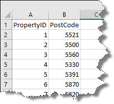
and
2) Geo-data:
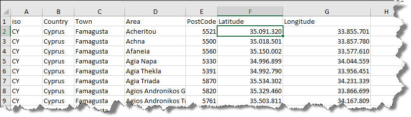
As you can see the "geo" data comprises of Latitude and Longitude sets for post codes that belong to an "Area" that belongs to a "Town"
When I load into Qlik Sense, it recognises the towns and country and automatically generates code for mapping the towns which is not what I want - I want to show properties in the "Area" they belong and not the city. I tried creating a GeoPoint using "MakeGeoPoint" but the application seems to lose the decimal points in the latitude and longitude (35.091.320 becomes 35091320) which maps nowhere of course.
I attach the Qlik Sense qvf along with the 2 Excel files in the hope that someone can point me to the right direction.
Thank you in advance
Alexis
- Mark as New
- Bookmark
- Subscribe
- Mute
- Subscribe to RSS Feed
- Permalink
- Report Inappropriate Content
In the file latitude and longitude are given as whole numbers. Also I think you can recognize a location either by post code or specifying its latitude and longitude. if you are giving the post code it will automatically recognize the location irrespective of lat,long and vice versa.
Hope that helps
- Mark as New
- Bookmark
- Subscribe
- Mute
- Subscribe to RSS Feed
- Permalink
- Report Inappropriate Content
Hi Alexis,
Are you using Qlik GeoAnalytics? Unfortunately there are no zip codes built in for Cyprus but lat long will work.
The coordinates looks funny, is it perhaps degrees, minutes and seconds?
The coordinates needs to be in decimal degrees, here's how you convert:
Degrees,minutes,seconds to decimal degrees converter
Thanks,
Patric Nordström
Qlik