Unlock a world of possibilities! Login now and discover the exclusive benefits awaiting you.
- Qlik Community
- :
- All Forums
- :
- GeoAnalytics
- :
- What is the WMS format for Geoanalytics to consume...
- Subscribe to RSS Feed
- Mark Topic as New
- Mark Topic as Read
- Float this Topic for Current User
- Bookmark
- Subscribe
- Mute
- Printer Friendly Page
- Mark as New
- Bookmark
- Subscribe
- Mute
- Subscribe to RSS Feed
- Permalink
- Report Inappropriate Content
What is the WMS format for Geoanalytics to consume ?
Hi,
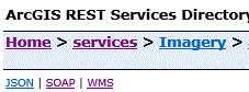
I have pulish map service with wms capability as follows. And this is the url. (for confidential reason, I block the server name in the url)
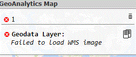
I use geoanalytics geodata layer source format wms , but the map doesnt work out for the url. And I got error message. can I ask if I have to follow specific wms url format so that geoanaytics can really load the imagery map via the URL?
- Mark as New
- Bookmark
- Subscribe
- Mute
- Subscribe to RSS Feed
- Permalink
- Report Inappropriate Content
Hi Wallace,
Please follow the WMS setup guide: Setting up a WMS as a background map in Qlik GeoAnalytics
It's hard to say without more info on your Esri system but the link should be something like this:
http://*-gis......com/arcgis/services/Imagery/SP_Riau_Mosaic/MapServer/WMSServer?LAYERS=<Insert layer name >&FORMAT=image%2Fpng&EXCEPTIONS=application%2Fvnd.ogc.se_inimage&TRANSPARENT=TRUE&SERVICE=WMS&REQUEST=GetMap&STYLES=
The link you provide is the GetCapabilites service that gives info on how to use this specific WMS.
Thanks,
Patric