Unlock a world of possibilities! Login now and discover the exclusive benefits awaiting you.
- Qlik Community
- :
- Forums
- :
- Forums by Product
- :
- Products (A-Z)
- :
- Qlik Sense
- :
- Documents
- :
- Setting up a Esri ArcGIS WFS source as a layer in ...
- Edit Document
- Move Document
- Delete Document
- Subscribe to RSS Feed
- Mark as New
- Mark as Read
- Bookmark
- Subscribe
- Printer Friendly Page
- Report Inappropriate Content
Setting up a Esri ArcGIS WFS source as a layer in Qlik GeoAnalytics (QGA)
- Move Document
- Delete Document and Replies
- Mark as New
- Bookmark
- Subscribe
- Mute
- Subscribe to RSS Feed
- Permalink
- Report Inappropriate Content
Setting up a Esri ArcGIS WFS source as a layer in Qlik GeoAnalytics (QGA)
Apr 2, 2021 4:20:45 AM
Apr 21, 2017 4:55:05 AM
QGA can consume geodata from many different sources including Esri ArcGIS online, here's what's needed to show the data as a feature layer in QGA.
Step-by-step guide
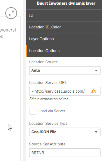
Start by figuring out the correct parameters. In this case the source is administrative boundaries (Buurt) of the Dutch city Zwolle.
- Usually an base url is given like this (https://services1.arcgis.com/3YlK2vfHGZtonb1r/ArcGIS/rest/services/Zwolle_WijkBuurt_gdb/FeatureServe...), follow and click on "Query" at the bottom
- Set parameters Where 1=1, Outfield BRTNR (this is the field we want to use as index) in, and set the output to geojson and clicked Query (Get)
- Try out the the geojson in geojson.io, realise that projection needs to be 4326 (WGS84), changed the url param : outSR=4326.
Note! If you want to use the builtin basemap, the geojson layer should be in WGS84 -> EPSG:4326 - And voilá a valid geojson url! https://services1.arcgis.com/3YlK2vfHGZtonb1r/ArcGIS/rest/services/Zwolle_WijkBuurt_gdb/FeatureServe...
- Check that the geojson works by setting it up as a static geodata layer.
- Then make a area layer with the geojson as input, BRTNR as dimension.I checked the geojson and used BRTNR as the "Source key attribute".
See the attached Sense app for more details. Note 1, this example requires Qlik GeoAnalytics. Note 2, this app features data from an external service which might be out of service.
Authentication in ArcGIS
Special note regarding Authentication in ArcGIS (Thanks to ssamuels for the solution)
The authentication when working with secured map services from ESRI can be solved by setting up a REST connection in the loadscript to retrieve a new access token from the REST API of ArcGIS Online. This is done by sending a GenerateToken request to the URL "https://www.arcgis.com/sharing/generateToken?parameters". The REST call must be a POST request over https and takes the following parameters:
username - Username of the user who wishes to get a token.
password - Password of user who wishes to get a token.
referer - The base URL of the web application that will invoke the services
expiration - The token expiration time in minutes (default value for this parameter is 60 minutes)
f - The response format. The value for this parameter must be "json".
The resulting access token is stored in the data model and can be used as a text variable to append to the location service url in the GeoAnalytics extension.
- Move Comment
- Delete Comment
- Mark as Read
- Mark as New
- Bookmark
- Permalink
- Report Inappropriate Content
Hi Patrick,
Great post! I followed your instructions and succeeded in adding the GeoJSON url from ArcGIS Online as area layer in Qlik Sense.
After constructing the GeoJSON url I noticed there is a token parameter and value at the end. Does this mean this will also work for secured feature layers?
Thanks,
Steven
- Move Comment
- Delete Comment
- Mark as Read
- Mark as New
- Bookmark
- Permalink
- Report Inappropriate Content
Hi Patrick,
I was wandering whether such magic base urls (like http://services1.arcgis.com or http://mapservices.prorail.nl) exist for other countries too?
If so, how to find them?
Thanks,
Denis
- Move Comment
- Delete Comment
- Mark as Read
- Mark as New
- Bookmark
- Permalink
- Report Inappropriate Content
Hi Osama,
To do a layer like the Esri server must be setup to deliver data as GeoJSON service.
Please contact your Esri system adminstrator to do that.
Thanks,
Patric
- Move Comment
- Delete Comment
- Mark as Read
- Mark as New
- Bookmark
- Permalink
- Report Inappropriate Content
Hi Steven,
Any parameter can be embedded in the url.
We also support header authentication like this:
https://username:password@www.example.com/index.htmlpassword@www.example.com/index.html
Note! username and password will not be sent as the part of the url, they be extracted from the call and embedded in the https header.
Thanks,
Patric
- Move Comment
- Delete Comment
- Mark as Read
- Mark as New
- Bookmark
- Permalink
- Report Inappropriate Content
Hi Denis,
Good question, they are not easy to find, I don't know of any global directory.
Good places to search are often national open data initiative, like https://opendata.swiss/ or https://data.gov.uk or https://data.gov.sg they tend to have listings of the public servers that are available.
Thanks,
Patric
- Move Comment
- Delete Comment
- Mark as Read
- Mark as New
- Bookmark
- Permalink
- Report Inappropriate Content
Hi Patrick,
When I create a geojson URL to connect to a secured feature layer in ArcGIS Online, the url becomes invalid after two weeks. The reason is the expiration of the token that is included in the url. Header authentication is not supported by the REST API of ArcGIS Online, so that's not an option. Do you have a solution for this?
Thanks,
Steven
- Move Comment
- Delete Comment
- Mark as Read
- Mark as New
- Bookmark
- Permalink
- Report Inappropriate Content
Hi Patric, you added my ProRail example to this document! 
You're welcome 😉
- Move Comment
- Delete Comment
- Mark as Read
- Mark as New
- Bookmark
- Permalink
- Report Inappropriate Content
Hi Steven, sorry not at the moment, hopefully we will have more advanced authentication later on.
- Move Comment
- Delete Comment
- Mark as Read
- Mark as New
- Bookmark
- Permalink
- Report Inappropriate Content
Ops, sorry Frank, do you want me to remove it?
- Move Comment
- Delete Comment
- Mark as Read
- Mark as New
- Bookmark
- Permalink
- Report Inappropriate Content
No, don't worry, it's an honour 😉