Unlock a world of possibilities! Login now and discover the exclusive benefits awaiting you.
- Qlik Community
- :
- Forums
- :
- Analytics
- :
- App Development
- :
- Problem with GEOMakepoint
- Subscribe to RSS Feed
- Mark Topic as New
- Mark Topic as Read
- Float this Topic for Current User
- Bookmark
- Subscribe
- Mute
- Printer Friendly Page
- Mark as New
- Bookmark
- Subscribe
- Mute
- Subscribe to RSS Feed
- Permalink
- Report Inappropriate Content
Problem with GEOMakepoint
I am unable to make the assembly of my map QlikSense
below my script
[jan_2016]:
LOAD [ano],
[num_rel],
[local],
[data_rel],
[setor],
[tipo_atual],
[tipo],
[nome_prop_empreend],
[end_empreend],
[cid_empreend],
[data_ini],
[fase],
[quantificacao],
[nome_rt_princ],
[cart_rt_princ],
[nom_fisc],
[situacao],
[cidade],
[hyperlink],
[num_art_princ],
[data_art_princ],
[fase_atual],
[alvara_mun]
FROM [lib://Desktop/jan_2016.txt]
(txt, utf8, embedded labels, delimiter is ';', msq);
[Planilha1]:
LOAD [num_rel],
[Latitude],
[Longitude],
GeoMakePoint(num(Latitude,'##,#######'),num(Longitude,'##,#######')) as location
FROM [lib://Desktop/latlog.xlsx]
(ooxml, embedded labels, table is Planilha1);
Accepted Solutions
- Mark as New
- Bookmark
- Subscribe
- Mute
- Subscribe to RSS Feed
- Permalink
- Report Inappropriate Content
Unfortunately without success ,
Already working with GIS software , in which I have ease in mapping .
But When We speak of Information in Images prefer Sense.
I would also like to Information Entering KML files and connect to BD mysql
- Mark as New
- Bookmark
- Subscribe
- Mute
- Subscribe to RSS Feed
- Permalink
- Report Inappropriate Content
Hi,
Try creating a new Dimension in your Master Items having field defined as GeoMakePoint(Latitude,Longitude) and give it a name 'GeoKey' (any name would do).
Once you are done with it, drag the map chart into your sheet and add 'GeoKey' as your dimension.
Example:
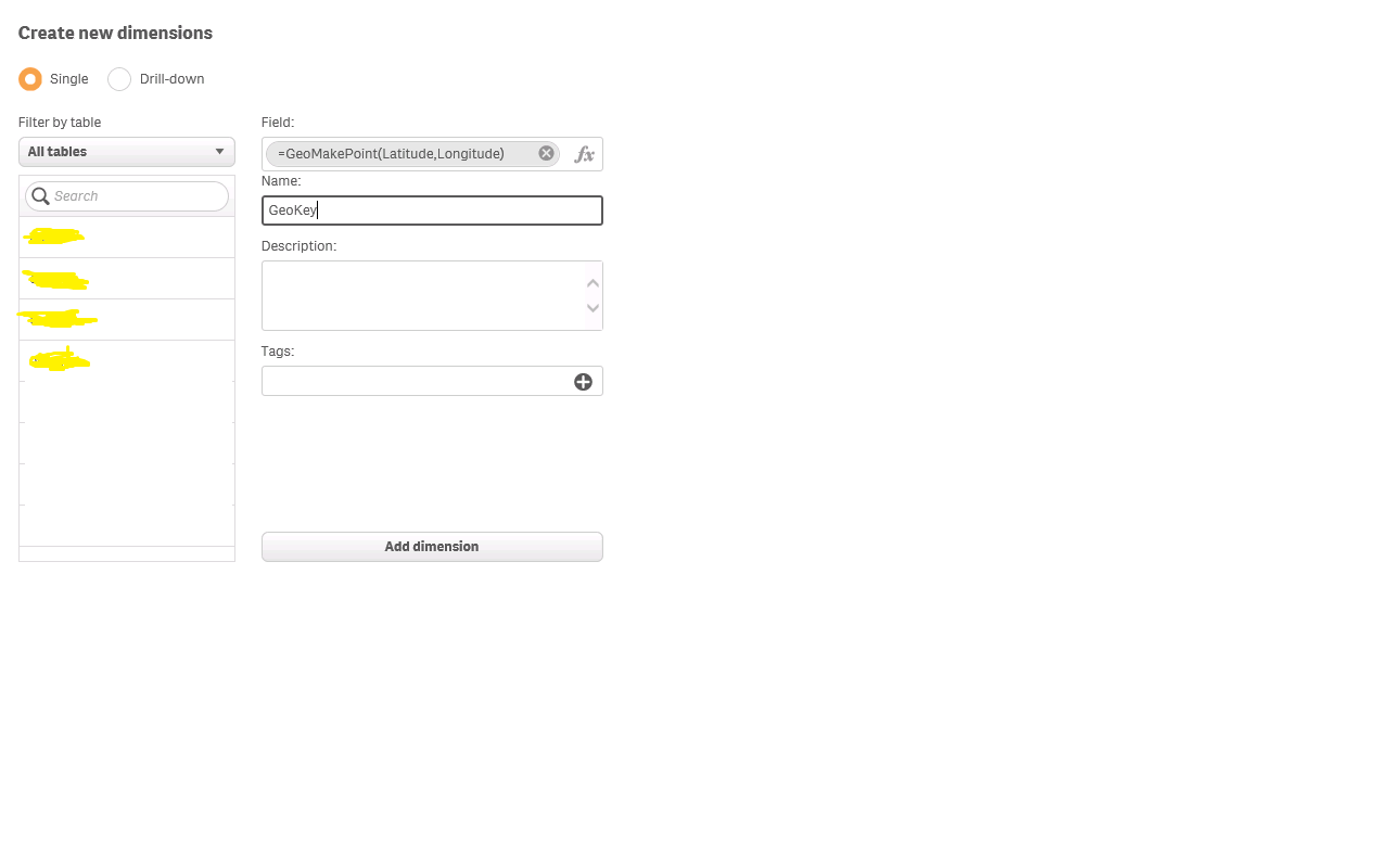
Regards,
Rohan
- Mark as New
- Bookmark
- Subscribe
- Mute
- Subscribe to RSS Feed
- Permalink
- Report Inappropriate Content
Unfortunately without success ,
Already working with GIS software , in which I have ease in mapping .
But When We speak of Information in Images prefer Sense.
I would also like to Information Entering KML files and connect to BD mysql