Unlock a world of possibilities! Login now and discover the exclusive benefits awaiting you.
- Qlik Community
- :
- Forums
- :
- Analytics
- :
- App Development
- :
- Qlik Sense geo mapping - unable to add coordinates
- Subscribe to RSS Feed
- Mark Topic as New
- Mark Topic as Read
- Float this Topic for Current User
- Bookmark
- Subscribe
- Mute
- Printer Friendly Page
- Mark as New
- Bookmark
- Subscribe
- Mute
- Subscribe to RSS Feed
- Permalink
- Report Inappropriate Content
Qlik Sense geo mapping - unable to add coordinates
Hi
I am using Qlik Sense server.
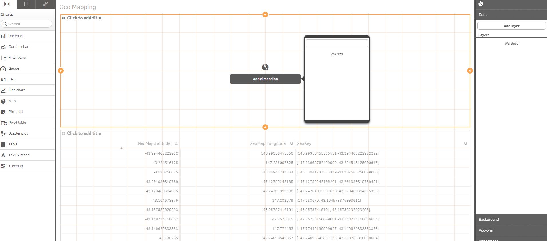
I have set up my GeoKey using geomakepoint():
GeoMakePoint(GeoMap.Latitude, GeoMap.Longitude) as GeoKey
However, I am unable to select the GeoKey when I create the map:
Any help would be appreciated.
Accepted Solutions
- Mark as New
- Bookmark
- Subscribe
- Mute
- Subscribe to RSS Feed
- Permalink
- Report Inappropriate Content
Michael, thanks for your response.
I found out what the issue was...
In my load script, I have the following line:
If( GeoMap.Latitude = 0 and GeoMap.Longitude = 0 , null(), GeoMakePoint(GeoMap.Latitude, GeoMap.Longitude)) as GeoKey
I did this because I have data without coordinates, and I want to hide this rather than show it it as [0 , 0] on the map. However, this doesn't recognise the field as a $geopoint, but as $text.
My workaround:
1. Change the load scrip to:
GeoMakePoint(GeoMap.Latitude, GeoMap.Longitude) as GeoKey
2. Set up the map visualisation using GeoKey (which is now recognised)
3. Reload the data with the original script:
If( GeoMap.Latitude = 0 and GeoMap.Longitude = 0 , null(), GeoMakePoint(GeoMap.Latitude, GeoMap.Longitude)) as GeoKey
This resolves the issue and allows me to hide null() coordinates.
- Mark as New
- Bookmark
- Subscribe
- Mute
- Subscribe to RSS Feed
- Permalink
- Report Inappropriate Content
Hello Andrew - this could be a few things.
- What version of Qlik Sense are you using?
The reason I ask, with 2.1 we added the ability to allow GeoMakePoint to work within the Master Items Dimensions. Sometimes people do this with an older version in which it does not work - it must be done in the load script. - Are you using GeoMakePoint in the script?
- Can you view your key field using the Data Model Viewer and see if it tagged like this: $geopoint

- Can you try this sample data attached and let me know if it works for you. (orders and Customers and Categories)
Can you attach your sample data as well - there may be a formatting issue with the Lat and Long,
Let's try these things first and we can take it from there.
note sure if you saw these videos either, but they may help as well: Using the Maps Chart Object - Points Maps - Part 1 - (video)
Please mark the appropriate replies as CORRECT / HELPFUL so our team and other members know that your question(s) has been answered to your satisfaction.
Regards,
Mike Tarallo
Qlik
Mike Tarallo
Qlik
- Mark as New
- Bookmark
- Subscribe
- Mute
- Subscribe to RSS Feed
- Permalink
- Report Inappropriate Content
Michael, thanks for your response.
I found out what the issue was...
In my load script, I have the following line:
If( GeoMap.Latitude = 0 and GeoMap.Longitude = 0 , null(), GeoMakePoint(GeoMap.Latitude, GeoMap.Longitude)) as GeoKey
I did this because I have data without coordinates, and I want to hide this rather than show it it as [0 , 0] on the map. However, this doesn't recognise the field as a $geopoint, but as $text.
My workaround:
1. Change the load scrip to:
GeoMakePoint(GeoMap.Latitude, GeoMap.Longitude) as GeoKey
2. Set up the map visualisation using GeoKey (which is now recognised)
3. Reload the data with the original script:
If( GeoMap.Latitude = 0 and GeoMap.Longitude = 0 , null(), GeoMakePoint(GeoMap.Latitude, GeoMap.Longitude)) as GeoKey
This resolves the issue and allows me to hide null() coordinates.
- Mark as New
- Bookmark
- Subscribe
- Mute
- Subscribe to RSS Feed
- Permalink
- Report Inappropriate Content
Hi Andrew --- great to hear, thanks for the update. Stay in touch with us and let us know how you do. we are here to help.
Regards,
Mike T
Qlik
Mike Tarallo
Qlik