Unlock a world of possibilities! Login now and discover the exclusive benefits awaiting you.
- Qlik Community
- :
- All Forums
- :
- QlikView App Dev
- :
- Re: GeoSpatial Solutions for Qlikview
- Subscribe to RSS Feed
- Mark Topic as New
- Mark Topic as Read
- Float this Topic for Current User
- Bookmark
- Subscribe
- Mute
- Printer Friendly Page
- Mark as New
- Bookmark
- Subscribe
- Mute
- Subscribe to RSS Feed
- Permalink
- Report Inappropriate Content
GeoSpatial Solutions for Qlikview
Hi, We are looking for a best solution for geospatials in qlikview. I know there is something called GeoQlik. Are there any other good options? Please let me know.
Thanks,
Ram
- Mark as New
- Bookmark
- Subscribe
- Mute
- Subscribe to RSS Feed
- Permalink
- Report Inappropriate Content
Hi, you could use a Google api , it is very easy to integrate(one differences with geoqlik is that is free)
I attached a doc to explain and a qvw example
good luck
Fernando
- Mark as New
- Bookmark
- Subscribe
- Mute
- Subscribe to RSS Feed
- Permalink
- Report Inappropriate Content
Hi Fernando, I followed the exact steps but don't get to see the map. I already have the latitude and longitude in my qlikview data model. How do I use it. If you can provide that step that'll be useful. The field names are called WorkLat and WorkLong. What is the statement that associates these fields with google maps?
- Mark as New
- Bookmark
- Subscribe
- Mute
- Subscribe to RSS Feed
- Permalink
- Report Inappropriate Content
Hi.. Ramkumar
Can you please attach your file.
- Mark as New
- Bookmark
- Subscribe
- Mute
- Subscribe to RSS Feed
- Permalink
- Report Inappropriate Content
No Senthil. I cannot copy, the file is in a production box. I'll explain you what is happening. I have the PostCode(Postal Code) that is already part of the model. I have an excel file containing the latitutde and longitudes of these postal codes. I brought them in and joined with the data model as follows:
WorkPostCodeData:
load PCode as [PostCode], Lat * pi() / 180 as WorkLat, Long * pi() /180 as WorkLong
from
pc_full_lat_long.csv
(txt, codepage is 1252, embedded labels, delimiter is ',', msq);
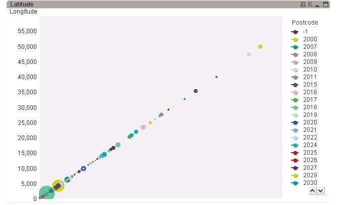
Once I did this I was able to do the distance analysis perfectly using the Haversine method. All I now want is the GeoSpatials, plot the numbers on the map.
- Mark as New
- Bookmark
- Subscribe
- Mute
- Subscribe to RSS Feed
- Permalink
- Report Inappropriate Content
Is this just a problem with my background dynamic image?
- Mark as New
- Bookmark
- Subscribe
- Mute
- Subscribe to RSS Feed
- Permalink
- Report Inappropriate Content
Hi.. Can you try the below code for Dynamic Image
='http://maps.google.com/maps/api/staticmap?center='
&
num(var_mid_lat, '##############', '.', ',' )
&
','
&
num(var_mid_long, '##############', '.', ',' )
&
'&zoom=$(var_zoom)'
&
'&maptype='&var_maptype
&
'&size='&map_size_x&'x'&map_size_y
&
'&sensor=false'
- Mark as New
- Bookmark
- Subscribe
- Mute
- Subscribe to RSS Feed
- Permalink
- Report Inappropriate Content
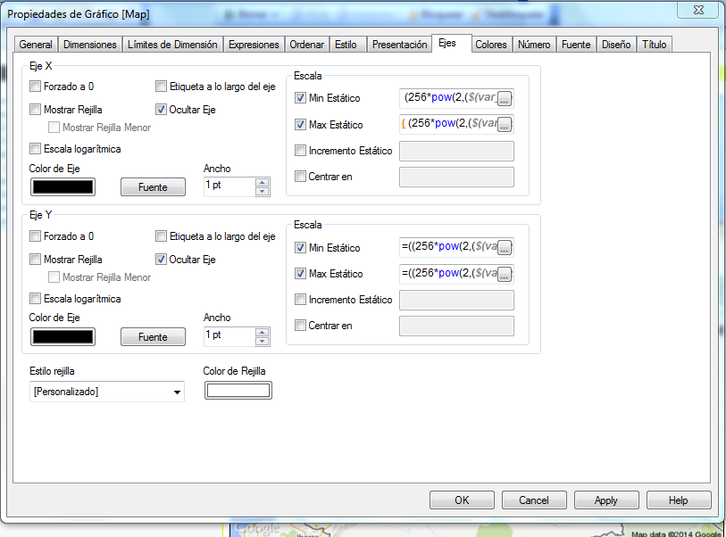
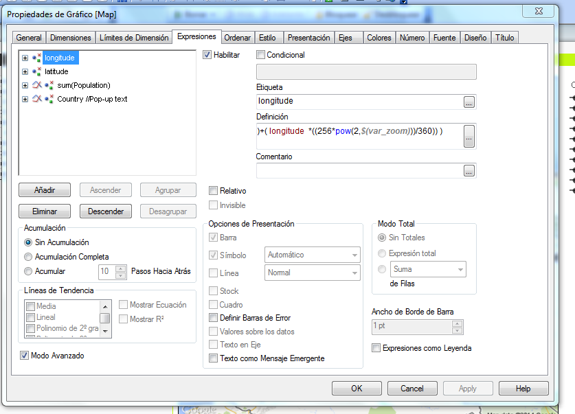
Hi Ramkumar
Could you please chekc that you have set all the correct properties in this tab attach?
have you internet conecction when you open the document?