Unlock a world of possibilities! Login now and discover the exclusive benefits awaiting you.
- Qlik Community
- :
- All Forums
- :
- QlikView App Dev
- :
- Google Maps Connection
- Subscribe to RSS Feed
- Mark Topic as New
- Mark Topic as Read
- Float this Topic for Current User
- Bookmark
- Subscribe
- Mute
- Printer Friendly Page
- Mark as New
- Bookmark
- Subscribe
- Mute
- Subscribe to RSS Feed
- Permalink
- Report Inappropriate Content
Google Maps Connection
Hi everybody!
Please find below my request:
I followed this topic https://community.qlikview.com/docs/DOC-3136
But when I finished the step of the connection with Google Map on page 13 in the word document.
This error appears:
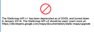
I want to use the connection for my application and I can't connect my data if the connection is not working.
Do you have suggestion regarding this problem and what is the possibility: free (open source) or pay (geoqlik)
I'm sure the error come the gmap key : do you have an idea ?
********************************************************************
// Google Maps in QlikView
// V0.85.2 - October 1st 2008 © Copyright QlikTech International AB 2008 / AES
// Google Maps Key
// get a key here http://code.google.com/apis/maps/signup.html
gmap_key = 'xx';
max_zoom_level = 17; //maximum value 17
// Variables required for calculating map
// No need to change these
var_pi180= '=pi()/180';
var_lat_offset= '0';
var_mc2= '=256*pow(2,$(var_zoom))';
var_mc1= '=256*pow(2,($(var_zoom)-1))';
var_mid_lat= '=min(latitude)+(1+var_lat_offset)*((max(latitude)-min(latitude))/2)';
var_mid_long= '=min(longitude)+(max(longitude)-min(longitude))/2';
var_zoom= '=max(aggr(if(max( round(256*pow(2,(_zoom_level -1)))+( longitude *((256*pow(2,_zoom_level ))/360)) )-min( round(256*pow(2,(_zoom_level -1)))+( longitude *((256*pow(2,_zoom_level ))/360)) ) <map_size_x AND max((256*pow(2,(_zoom_level-1)))+((0.5*log((1+(sin((latitude)*pi()/180)))/(1-(sin((latitude)*pi()/180)))))*((-256*pow(2,_zoom_level))/(2*pi()))))-min((256*pow(2,(_zoom_level-1)))+((0.5*log((1+(sin((latitude)*pi()/180)))/(1-(sin((latitude)*pi()/180)))))*((-256*pow(2,_zoom_level))/(2*pi()))))<map_size_y,_zoom_level,1),_zoom_level))';
var_maptype= '=if(isnull(only(maptype)),fieldvalue( '&chr(39)&'maptype'&chr(39)&', 1 ),maptype)';
map_size_x= '400';
map_size_y= '400';
SET HidePrefix='_' ;
// Field required for calcualting best zoom level
_zoom_level:
Load RecNo( ) as _zoom_level autogenerate(max_zoom_level);
maptype:
LOAD * INLINE [
maptype
roadmap
mobile
satellite
terrain
hybrid
];
- Tags:
- googlemaps
Accepted Solutions
- Mark as New
- Bookmark
- Subscribe
- Mute
- Subscribe to RSS Feed
- Permalink
- Report Inappropriate Content
If you want an advice after many research I find this possibilities :
- Buy the solution : Google Maps, MapBox Geo-Qlik or Articque Map
- Use Map interactive with SVG in web page, it's means we need to realise an extract of the data
- Dowload if you have the recovery in your server open source Map like OpenStreetMap 20Go
So please, if you have any advice regarding this soft do not hesitate to let me know...