Unlock a world of possibilities! Login now and discover the exclusive benefits awaiting you.
- Qlik Community
- :
- All Forums
- :
- QlikView Integrations
- :
- Re: Google Maps - Cluster
- Subscribe to RSS Feed
- Mark Topic as New
- Mark Topic as Read
- Float this Topic for Current User
- Bookmark
- Subscribe
- Mute
- Printer Friendly Page
- Mark as New
- Bookmark
- Subscribe
- Mute
- Subscribe to RSS Feed
- Permalink
- Report Inappropriate Content
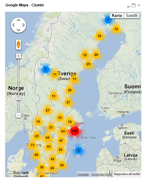
Google Maps - Cluster
Google Maps Extension with Cluster support.
QlikTech takes no responsibility for any code and QlikTech Support Agreement does not cover issues with this extension.
Please review Googles license agreement before you put this into production.
Introduction
This is a QlikView extension object that integrates Google Maps Javascript API V3 and a third party library called MarkerClusterPlus into QlikView.
Load a set a coordinates into QlikView and visualize them together with this extension. The clustering feature is create when you have alot of data points and needs to group/cluster them together for greater visability and performance.
The maxzoom property defines at what zoom level you want your markers clustered. The grid size property controls how big or small cluster grid size you want.
You can either use the extension 'as is' or use it as a base to further customize it to fit your needs.
Download the extension and view source code at: https://github.com/mindspank/GoogleMaps-Cluster-QV11
If you build something awesome please share it with the community!
Live long and prosper.
2015-02-15
Removed download from post, please grab the latest version from Github instead.
2014-02-03
Various fixes.
2014-01-09
There has been numerous upgrades to the extension.
Now clusters now display the value of your expression and with added support to include more information in pop-up labels.
Example grayscale styled map included.
Possibility to show only a single cluster icon style if you do not want it to scale according to the number of markers in the cluster.
2013-06-17
Added custom marker support. Now you can specify a url for an custom marker. Accepts all major image file types.
- Mark as New
- Bookmark
- Subscribe
- Mute
- Subscribe to RSS Feed
- Permalink
- Report Inappropriate Content
Hi Alexander,
Could you just clarify me please in essential point the Googles license agreemen ?
If I installe folder .qar I need to pay Google for that, could you clarify me the utilisation regarding that please.
Many thanks for your help.
Axel
- Mark as New
- Bookmark
- Subscribe
- Mute
- Subscribe to RSS Feed
- Permalink
- Report Inappropriate Content
- Mark as New
- Bookmark
- Subscribe
- Mute
- Subscribe to RSS Feed
- Permalink
- Report Inappropriate Content
Many thanks for the link S khan, happy new year !
- Mark as New
- Bookmark
- Subscribe
- Mute
- Subscribe to RSS Feed
- Permalink
- Report Inappropriate Content
Happy New Year!!!
- Mark as New
- Bookmark
- Subscribe
- Mute
- Subscribe to RSS Feed
- Permalink
- Report Inappropriate Content
Hi Alexander,
I am not getting anything. i am using this below coordinates.
| Longitude | Latitude | Branch Name | Branch_ID |
| 25.131900600 | 121.498596000 | Zhongxiao Branch | 607_002 |
| 24.252632323 | 120.720730450 | Fengyuan Branch | 607_006 |
| 25.066666400 | 121.499998000 | Sanchong Branch | 607_015 |
| 24.155466000 | 120.665329000 | Taichung Branch | 607_001 |
I am using IE11 and checking it n Webview of desktop.
I am not able to see anything but the hand come when i hover around . check image view1.
My dimensions and expressions are as view 2
Can you please help
- Mark as New
- Bookmark
- Subscribe
- Mute
- Subscribe to RSS Feed
- Permalink
- Report Inappropriate Content
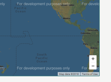
Hello. Today when I open the Qlikview file with the map extension I got the "For development purposes only" watermark on the map. I've been using this extension for a month but haven't encounter this issue before. May I know what is happening?
- Mark as New
- Bookmark
- Subscribe
- Mute
- Subscribe to RSS Feed
- Permalink
- Report Inappropriate Content
Hi Alexander,
I'm trying to use extension which you public in Q11.2 but I have a partial error it is asking API etc?
When I click the one store it is saying error. do you have updated one or what we have to do?
thx
Best
M
- Mark as New
- Bookmark
- Subscribe
- Mute
- Subscribe to RSS Feed
- Permalink
- Report Inappropriate Content
Hi,
Alexander's files were out of date, giving a mistake.
I updated.
Thanks Alexander Karlsson!..
İmportant!:Type the "apikey" you own in the script.js file.
Good luck everyone!..
- Mark as New
- Bookmark
- Subscribe
- Mute
- Subscribe to RSS Feed
- Permalink
- Report Inappropriate Content
Hey,
I have a white screen when adding the extension object, nothing seems to happen with this new files.
API key is valid.
I use QV12
Thanks for your help
- Mark as New
- Bookmark
- Subscribe
- Mute
- Subscribe to RSS Feed
- Permalink
- Report Inappropriate Content
Hi, Thank you for developing this extension. It's very helpful.
I got stuck at a stage where i was unable to load a polygon data in this extension. Is there a way to add a polygon data as a .shp / kml / geojson.
Help would be appreciated.
Thank You
Chaitanya