Unlock a world of possibilities! Login now and discover the exclusive benefits awaiting you.
- Qlik Community
- :
- All Forums
- :
- QlikView Integrations
- :
- Re: Google Maps - Marker
- Subscribe to RSS Feed
- Mark Topic as New
- Mark Topic as Read
- Float this Topic for Current User
- Bookmark
- Subscribe
- Mute
- Printer Friendly Page
- Mark as New
- Bookmark
- Subscribe
- Mute
- Subscribe to RSS Feed
- Permalink
- Report Inappropriate Content
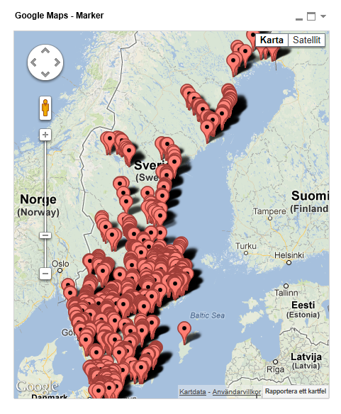
Google Maps - Marker
Google Maps Extension with Markers.
QlikTech takes no responsibility for any code and QlikTech Support Agreement does not cover issues with this extension.
Please review Googles license agreement before you put this into production.
Introduction
This is a QlikView extension object that integrates Google Maps Javascript API V3 into QlikView.
Load a set a coordinates into QlikView and visualize them together with this extension. This extension will plot every single data point as a marker on the map so if you have a large amount of markers please be aware that it might have some performance impact. If you are experiencing performance issues look into the cluster extension instead: http://community.qlik.com/message/325640
You can either use the extension 'as is' or use it as a base to further customize it to fit your needs.
Custom Markers
Added support for custom markers images. In the properties dialog you now have the option to specify a custom image.
You can either have a static image or let the expression evaluate one for you, for example:
=If(MyExpression > 1, 'http://image_for_true', 'http://image_for_false'). If you do not specify an url or enter an invalid one the extension will fallback to the standard marker.
Supported image extensions are bmp, jpg, jpeg, tiff, png and gif.
You can host the images through the qlikview webserver or through IIS.
If you build something awesome please share it with the community!
Live long and prosper.
- « Previous Replies
- Next Replies »
- Mark as New
- Bookmark
- Subscribe
- Mute
- Subscribe to RSS Feed
- Permalink
- Report Inappropriate Content
Hi Kris,
in the jscript.js, after the line"map.fitBounds(latlngbounds);"
add this:
if(i==1){
map.setZoom(18);
};
Cheers
- Mark as New
- Bookmark
- Subscribe
- Mute
- Subscribe to RSS Feed
- Permalink
- Report Inappropriate Content
Hi Alex,
I have an requirement i am trying to implement it with the map but not able to understand the Script.JS as i am new to it,
what i need is the user will select the source and destination in the dashboard then i need to show the markers for source and destination and a line to connect them , how can i do that?
Any help would be highly appreciated
Thanks,
Vivek
- Mark as New
- Bookmark
- Subscribe
- Mute
- Subscribe to RSS Feed
- Permalink
- Report Inappropriate Content
Hey vivek,
This extension does not support polylines and/or connecting markers.
- Mark as New
- Bookmark
- Subscribe
- Mute
- Subscribe to RSS Feed
- Permalink
- Report Inappropriate Content
HI, Alex,
I am using your updated extension Google Map-Marker with pop-up label option.
When I hover on the marker the map moves up/down based on the position of the marker. where can I make the position of the map static in script upon hovering of mouse on marker.
Thanks!
- Mark as New
- Bookmark
- Subscribe
- Mute
- Subscribe to RSS Feed
- Permalink
- Report Inappropriate Content
Hello. I would like to ask you a question regarding google maps Marker.
I have made a working google map overview for our customers. Now i would like to have a visual difference between the Customers.
The table looks like:
Customer - Sales Agent - LAT - LON
Is it possible to color the markers different for every sales agent? I would like to see the difference on the map, right now there is one color for every customer...
Any help appreciated... thanks.
- Mark as New
- Bookmark
- Subscribe
- Mute
- Subscribe to RSS Feed
- Permalink
- Report Inappropriate Content
Hi all,
I've been using this extension for a long time and it was always working fine.
Since last friday I have a strange error.
If we try to openthe the tab with extion in our accesspoint it is not opening and the page is not reacting.
If I try to open it in my desktop with the webview it is'nt working.
I've installed the extension again and restart the services.
Now I can open the tab again in my accesspoint but it is not showing any data.
But the users can work with the dashboard.
Am I the only one with this problem?
Regards,
Kris
- Mark as New
- Bookmark
- Subscribe
- Mute
- Subscribe to RSS Feed
- Permalink
- Report Inappropriate Content
Hi Team,
I am using multi layer map in which polygon and point map both are there.In point map marker images are not visible from access point .I can see those marker images in desktop.
akl
Can anyone help me on this?
Regards,
Mayank
- Mark as New
- Bookmark
- Subscribe
- Mute
- Subscribe to RSS Feed
- Permalink
- Report Inappropriate Content
Hi Alexender,
I am facing issue related to marker icon images in point map.Images not visible in access point.
Can you guide me on this?
Regards,
Mayank
- Mark as New
- Bookmark
- Subscribe
- Mute
- Subscribe to RSS Feed
- Permalink
- Report Inappropriate Content
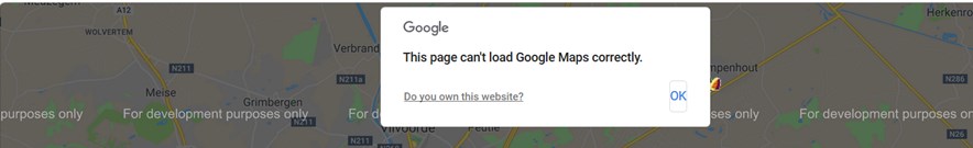
Hi,
I'm using this extension for a while now.
Since a few weeks I get this message.
What can I do about it?
- Mark as New
- Bookmark
- Subscribe
- Mute
- Subscribe to RSS Feed
- Permalink
- Report Inappropriate Content
I found the solution.
Edit the file C:\ProgramData\QlikTech\QlikViewServer\Extensions\Objects\GoogleMaps - Marker\scritp.js
replace: Qva.LoadScript('https://maps.google.com/maps/api/js?sensor=false&callback=map_init')
with Qva.LoadScript('https://maps.googleapis.com/maps/api/js?key=YourKey&callback=map_init')
regards,
Kris
- « Previous Replies
- Next Replies »