Unlock a world of possibilities! Login now and discover the exclusive benefits awaiting you.
- Qlik Community
- :
- All Forums
- :
- QlikView App Dev
- :
- Problem with Google Map
- Subscribe to RSS Feed
- Mark Topic as New
- Mark Topic as Read
- Float this Topic for Current User
- Bookmark
- Subscribe
- Mute
- Printer Friendly Page
- Mark as New
- Bookmark
- Subscribe
- Mute
- Subscribe to RSS Feed
- Permalink
- Report Inappropriate Content
Problem with Google Map
Hi all,
I'm traying to load google map and I use this document that I have find in the communitySteps for beginners to implement Google Maps in Qlikview , I get tne neccessary data but when I try to create the chart I didn't get any information .
Could same one explain me what is the problem ?
- Tags:
- qlikview_scripting
- Mark as New
- Bookmark
- Subscribe
- Mute
- Subscribe to RSS Feed
- Permalink
- Report Inappropriate Content
Rahma,
Can you please share me the application which you creating for G Maps
- Mark as New
- Bookmark
- Subscribe
- Mute
- Subscribe to RSS Feed
- Permalink
- Report Inappropriate Content
Sorry I didn't understand What didi you mean by Application (I have alredy attached a print screen from my QlikView application ) and if you mean my script :
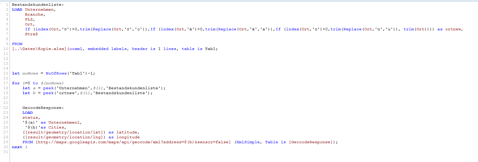
and this is the G map Script:
// Google Maps Key
// get a key here http://code.google.com/apis/maps/signup.html
// gmap_key = 'xx';
max_zoom_level = 17; //maximum value 17
// Variables required for calculating map
// No need to change these
var_pi180= '=pi()/180';
var_lat_offset= '0';
var_mc2= '=256*pow(2,$(var_zoom))';
var_mc1= '=256*pow(2,($(var_zoom)-1))';
var_mid_lat= '=min(Latitude)+(1+var_lat_offset)*((max(Latitude)-min(Latitude))/2)';
var_mid_long= '=min(Longitude)+(max(Longitude)-min(Longitude))/2';
var_zoom= '=max(aggr(if(max( round(256*pow(2,(_zoom_level -1)))+( Longitude *((256*pow(2,_zoom_level ))/360)) )-min( round(256*pow(2,(_zoom_level -1)))+( Longitude *((256*pow(2,_zoom_level ))/360)) ) <map_size_x AND max((256*pow(2,(_zoom_level-1)))+((0.5*log((1+(sin((Latitude)*pi()/180)))/(1-(sin((Latitude)*pi()/180)))))*((-256*pow(2,_zoom_level))/(2*pi()))))-min((256*pow(2,(_zoom_level-1)))+((0.5*log((1+(sin((Latitude)*pi()/180)))/(1-(sin((Latitude)*pi()/180)))))*((-256*pow(2,_zoom_level))/(2*pi()))))<map_size_y,_zoom_level,1),_zoom_level))';
var_maptype= '=if(isnull(only(maptype)),fieldvalue( '&chr(39)&'maptype'&chr(39)&', 1 ),maptype)';
map_size_x= '640';
map_size_y= '400';
SET HidePrefix='_' ;
// Field required for calcualting best zoom level
_zoom_level:
Load RecNo( ) as _zoom_level autogenerate(max_zoom_level);
maptype:
LOAD * INLINE [
maptype
roadmap
mobile
satellite
terrain
hybrid
];
set hideprefix = 'maptype';.
As informatiom I have the complete adress of my clients (Street , Zip code ) if you have another suggestion , I will be pleased for that .
