Unlock a world of possibilities! Login now and discover the exclusive benefits awaiting you.
- Qlik Community
- :
- Forums
- :
- Analytics
- :
- App Development
- :
- Cities poorly placed in a map.
- Subscribe to RSS Feed
- Mark Topic as New
- Mark Topic as Read
- Float this Topic for Current User
- Bookmark
- Subscribe
- Mute
- Printer Friendly Page
- Mark as New
- Bookmark
- Subscribe
- Mute
- Subscribe to RSS Feed
- Permalink
- Report Inappropriate Content
Cities poorly placed in a map.
Hello.
I am trying to show cities of Spain in a map. When I show the map, several cities are poorly placed, because it confused the name of spanish cities with others with same name in America.
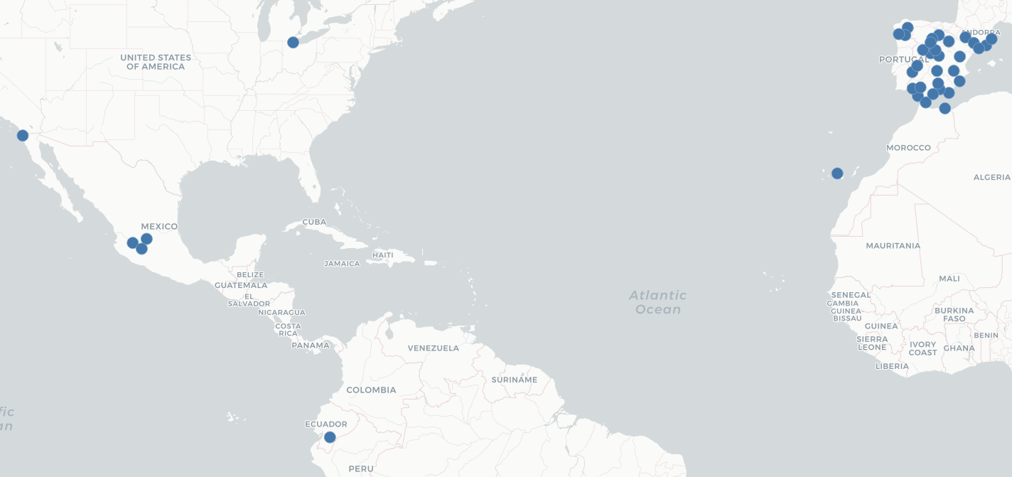
I have the information in a table relationed with main table. This is correct.
How I can say to Qlik than my cities are from Spain? or How I can use latitude and longitude to placed them?
Thanks and regards.
Accepted Solutions
- Mark as New
- Bookmark
- Subscribe
- Mute
- Subscribe to RSS Feed
- Permalink
- Report Inappropriate Content
Looks like you cannot reference a calculated field as a geo data field. 😕 At least in the version on the computer I am currently using - June 2017. However, if you have the field in the data file, it will work:

- Mark as New
- Bookmark
- Subscribe
- Mute
- Subscribe to RSS Feed
- Permalink
- Report Inappropriate Content
Hello!
If you are using the data manager to load the data, you can associate the field with your cities to a country: Changing field types (check point 4 at the end of the page).
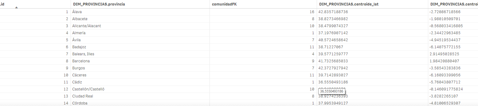
If you have longitude and latitude then either directly use the data manager which will create the geopoints automatically or use the script: Loading map data
- Mark as New
- Bookmark
- Subscribe
- Mute
- Subscribe to RSS Feed
- Permalink
- Report Inappropriate Content
Hello Ivan.
I didn't know this. Thanks.
But the link of the documentation doesn't say how put 'Spain', only if is a city, county or country code. Where I can write that is 'Spain'?
And if I create a new column with the field 'Spain', I can't select this new field like GeoData, so Qlik don't recognize the cities like from Spain.
Thanks again and regards.
- Mark as New
- Bookmark
- Subscribe
- Mute
- Subscribe to RSS Feed
- Permalink
- Report Inappropriate Content
Looks like you cannot reference a calculated field as a geo data field. 😕 At least in the version on the computer I am currently using - June 2017. However, if you have the field in the data file, it will work:
- Mark as New
- Bookmark
- Subscribe
- Mute
- Subscribe to RSS Feed
- Permalink
- Report Inappropriate Content
Great!
I did it. I include new column. Then I select the country in the column 'city'. Now the filter works.
Thanks.
I have other problem now. I should do the same with states of Spain. But in geodata I can't select 'state' in option.
But it is different problem.
If you know the solution of the last, I would be very very thankful hehe.
Thanks again and regards.
- Mark as New
- Bookmark
- Subscribe
- Mute
- Subscribe to RSS Feed
- Permalink
- Report Inappropriate Content
I think this option is for cities and countries only. If you want the states/regions, you should
- either have longitude and latitude that point to the center of the region so you can create a point map
- or KML file that will allow you to create an area map. Check this topic: KLM File for Spain
If this doesn't work, maybe open a new topic so that more people can join the discussion. 