Unlock a world of possibilities! Login now and discover the exclusive benefits awaiting you.
- Qlik Community
- :
- Forums
- :
- Analytics & AI
- :
- Products & Topics
- :
- App Development
- :
- US Map show only selected State
- Subscribe to RSS Feed
- Mark Topic as New
- Mark Topic as Read
- Float this Topic for Current User
- Bookmark
- Subscribe
- Mute
- Printer Friendly Page
- Mark as New
- Bookmark
- Subscribe
- Mute
- Subscribe to RSS Feed
- Permalink
- Report Inappropriate Content
US Map show only selected State
Hi everyone, can we ask Qlik Sense to show only one selected state, say NY state instead of whole country, on a map? I'm using point layer map with OpenStreetMap background, is it possible to do so?
Thanks!
X
- Tags:
- map
- qlik sense
- Mark as New
- Bookmark
- Subscribe
- Mute
- Subscribe to RSS Feed
- Permalink
- Report Inappropriate Content
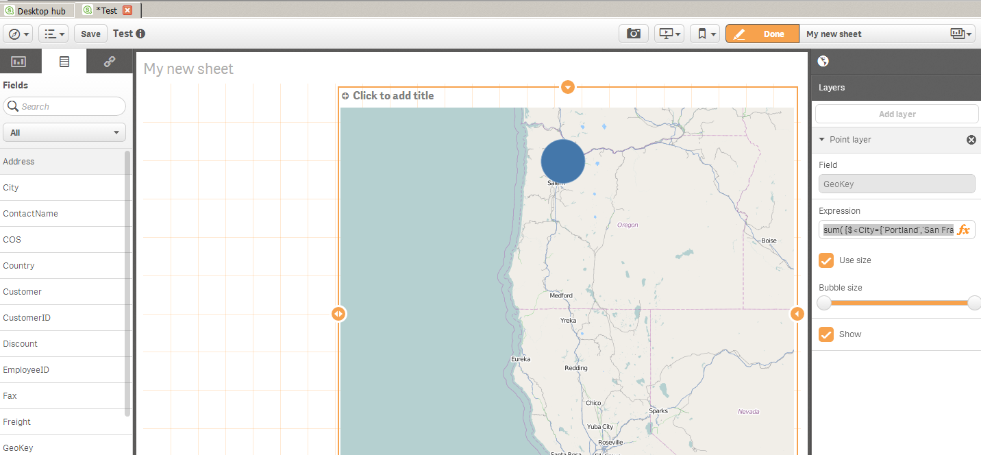
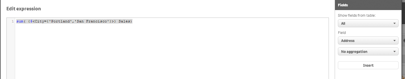
You could adjust the expression in the point layer to focus on a geographic area , as long as the value of the geographic area is represented in your data model somewhere.
Below, i have a global data set but on the right i am using a SET ANALYSIS statement within the expression to focus the context of the points to a geographic area. In this case its defined by City which i have defined as Portland or San Francisco.
sum( {$<City={'Portland','San Francisco'}>} Sales)
If you have State it could be something like this for you:
sum( {$<State ={'New York'}>} Sales)
- Mark as New
- Bookmark
- Subscribe
- Mute
- Subscribe to RSS Feed
- Permalink
- Report Inappropriate Content
Hi Jonathan, thanks but what if I need the map to be cut into state map, say <State ={'New York'}>, then I only want the map to show NY state not other states?
- Mark as New
- Bookmark
- Subscribe
- Mute
- Subscribe to RSS Feed
- Permalink
- Report Inappropriate Content
Consider using a KML file of NY State in lieu of a slippy map server as what i'm describing really just amounts to a zoom which is not state specific.
You can use KML files as data source in Qlik Sense to load state specific maps and shows points on the map too.
- Mark as New
- Bookmark
- Subscribe
- Mute
- Subscribe to RSS Feed
- Permalink
- Report Inappropriate Content
Hi Xuan - with respect to what Jonathan is stating in regards to KML see this video as an example.
Qlik Sense Desktop - Using Maps (Beta) Chart Object (video)
Please mark the appropriate replies as helpful / correct so our team and other members know that your question(s) has been answered to your satisfaction.
Regards,
Mike
Mike Tarallo
Qlik
- Mark as New
- Bookmark
- Subscribe
- Mute
- Subscribe to RSS Feed
- Permalink
- Report Inappropriate Content
Thanks, I tried TX kml file. there's no point layer, only area layer, which I cannot make bubble chart with.
Actually my problem could be solved if I zoom -in my US map with point layer, but when I zoom in, there's too much details and the state boundary disappears. If it only shows a state boundary with dots on it, then my problem is solved.
Too much details on the map sometimes is not what we want....
X
- Mark as New
- Bookmark
- Subscribe
- Mute
- Subscribe to RSS Feed
- Permalink
- Report Inappropriate Content
Hi Michael, thanks for that!
X
- Mark as New
- Bookmark
- Subscribe
- Mute
- Subscribe to RSS Feed
- Permalink
- Report Inappropriate Content
In the 1.0 release, Qlik Sense should also support point data from KML (area / polygons has been there since beta so you are correct there). I haven't tried it but i believe it is supposed to be possible.
For the zoom approach, have you tried all the slippy map servers to see if there is an optimum zoom. If there is i think we may be able to manually adjust your expression or even data model to 'anchor' it correctly as a starting point.
- Mark as New
- Bookmark
- Subscribe
- Mute
- Subscribe to RSS Feed
- Permalink
- Report Inappropriate Content
Hi Xuan,
You can do this by keeping the Autozoom on in presentation tab, so whenever you select state or country from your selection it will zoom into that part of the Map. This is possible in point layer only not in area layer type.
Regards,
Rajan Kasbe