Unlock a world of possibilities! Login now and discover the exclusive benefits awaiting you.
- Qlik Community
- :
- Forums
- :
- Analytics
- :
- New to Qlik Analytics
- :
- Issue with Maps in QlikSense desktop(Map not visib...
- Subscribe to RSS Feed
- Mark Topic as New
- Mark Topic as Read
- Float this Topic for Current User
- Bookmark
- Subscribe
- Mute
- Printer Friendly Page
- Mark as New
- Bookmark
- Subscribe
- Mute
- Subscribe to RSS Feed
- Permalink
- Report Inappropriate Content
Issue with Maps in QlikSense desktop(Map not visible; Data points appear on grey area)
Hi All, I have an issue with Maps in QlikSense desktop application. While the dots(data points) are visible, I am unable to view the map. The data points seem to be plotted on a grey area. Below is the image for reference purpose(blue circle). Kindly help me in the same.
- Mark as New
- Bookmark
- Subscribe
- Mute
- Subscribe to RSS Feed
- Permalink
- Report Inappropriate Content

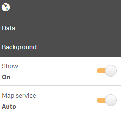
Check your Show and Map Service is ON.
Also check the Latitude and Longitude correctly mapped to the location,
You would need
GeoMakePoint(Latitude,Longitude) as GeoKey, <<< write this in Script Editor and use GeoKey as Points Layer. (if you've not already done it).
you can also add your own maps provided by Qlik Sense.
Switch off Map Service and use any of the links in URL
http://tile.openstreetmap.org/${z}/${x}/${y}.png
http://a.tile.opencyclemap.org/cycle/${z}/${x}/${y}.png
http://b.tile.opencyclemap.org/cycle/${z}/${x}/${y}.png
http://c.tile.opencyclemap.org/cycle/${z}/${x}/${y}.png
- Mark as New
- Bookmark
- Subscribe
- Mute
- Subscribe to RSS Feed
- Permalink
- Report Inappropriate Content
for the background to work is internet is working?
- Mark as New
- Bookmark
- Subscribe
- Mute
- Subscribe to RSS Feed
- Permalink
- Report Inappropriate Content
I have found that using Desktop at a client (external) with a Firewall can sometimes cause issues. Does anyone know if this is a port issue? Is there any way to change this?