Unlock a world of possibilities! Login now and discover the exclusive benefits awaiting you.
Announcements
Accelerate Your Success: Fuel your data and AI journey with the right services, delivered by our experts.
Learn More
- Qlik Community
- :
- Forums
- :
- Analytics
- :
- New to Qlik Analytics
- :
- Re: Map not showing polygons with NULL value
Options
- Subscribe to RSS Feed
- Mark Topic as New
- Mark Topic as Read
- Float this Topic for Current User
- Bookmark
- Subscribe
- Mute
- Printer Friendly Page
Turn on suggestions
Auto-suggest helps you quickly narrow down your search results by suggesting possible matches as you type.
Showing results for
Anonymous
Not applicable
2018-05-18
11:29 AM
- Mark as New
- Bookmark
- Subscribe
- Mute
- Subscribe to RSS Feed
- Permalink
- Report Inappropriate Content
Map not showing polygons with NULL value
Hi all,
I upgraded my Qlik to the April 2018 edition from the previous edition and now I am having an issue with the mapping.
In the map below I displaying the polygons by a measure. The ones that are gray have a measure of 0.
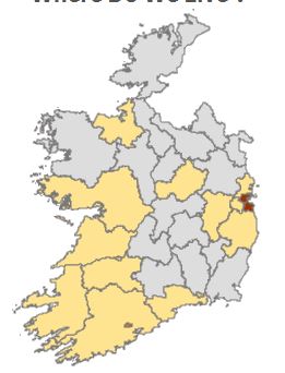
In the new edition when I create the same map, it filters out the grayed out counties which I do not want to happen. Anyone know a work around? I have selected show null values and tried near everything but I can not get it to show the grayed out polygons.
- Tags:
- map
1 Reply
Partner - Contributor II
2020-05-05
08:09 AM
- Mark as New
- Bookmark
- Subscribe
- Mute
- Subscribe to RSS Feed
- Permalink
- Report Inappropriate Content
Did you find a solution for this problem?
445 Views
Community Browser