Unlock a world of possibilities! Login now and discover the exclusive benefits awaiting you.
- Qlik Community
- :
- Forums
- :
- Analytics
- :
- New to Qlik Analytics
- :
- maps
- Subscribe to RSS Feed
- Mark Topic as New
- Mark Topic as Read
- Float this Topic for Current User
- Bookmark
- Subscribe
- Mute
- Printer Friendly Page
- Mark as New
- Bookmark
- Subscribe
- Mute
- Subscribe to RSS Feed
- Permalink
- Report Inappropriate Content
maps
hi,
I'm asking a suggest.
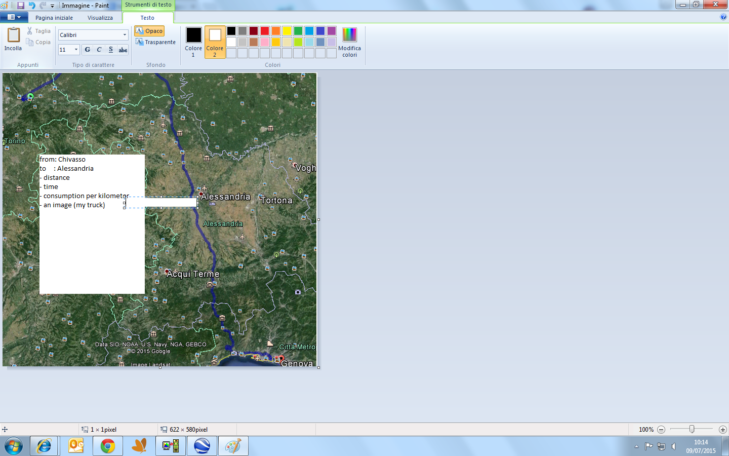
Using Qlik Sense, I would like to load a similar map.
My trucks run all days
from a .... city (Chivasso)
to a .... city (Alessandria)
Maps have to draw:
- route
- distance
- time
- consumption per kilometer
- an image (my truck)
as overlay
as below
- Mark as New
- Bookmark
- Subscribe
- Mute
- Subscribe to RSS Feed
- Permalink
- Report Inappropriate Content
hi
with the basic maps in sense you won't be able to achieve your request
but using a gis extension like qlikmaps or geoqlik you'll be able to do it
please not that those extensions are priced and licensed
- Mark as New
- Bookmark
- Subscribe
- Mute
- Subscribe to RSS Feed
- Permalink
- Report Inappropriate Content
hi,
but if i use google maps or google earth?
Also them are priced and licensed
- Mark as New
- Bookmark
- Subscribe
- Mute
- Subscribe to RSS Feed
- Permalink
- Report Inappropriate Content
yes you are right
what i meant that you need to contact a third party company
in order to run either qlikmaps (analytics8) or geoqlik(Business geographic)
- Mark as New
- Bookmark
- Subscribe
- Mute
- Subscribe to RSS Feed
- Permalink
- Report Inappropriate Content
ok.
I give up

- Mark as New
- Bookmark
- Subscribe
- Mute
- Subscribe to RSS Feed
- Permalink
- Report Inappropriate Content
hi
don't give up
i qlikmaps what you can build what you described in no time
- Mark as New
- Bookmark
- Subscribe
- Mute
- Subscribe to RSS Feed
- Permalink
- Report Inappropriate Content
hi,
but it isn't open source and for me it's a problem,
I'm freezing the request while i will not have news.
- Mark as New
- Bookmark
- Subscribe
- Mute
- Subscribe to RSS Feed
- Permalink
- Report Inappropriate Content
hi,

- Mark as New
- Bookmark
- Subscribe
- Mute
- Subscribe to RSS Feed
- Permalink
- Report Inappropriate Content
Usastes un *.qar?
- Mark as New
- Bookmark
- Subscribe
- Mute
- Subscribe to RSS Feed
- Permalink
- Report Inappropriate Content
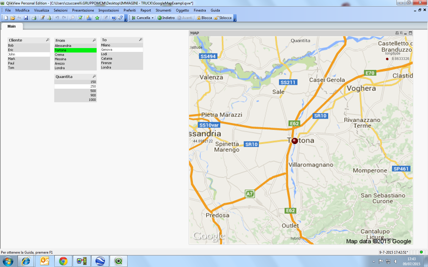
hi Fabio,
Steps for beginners to implement Google Maps in Qlikview
I used this guide.
If you goal pls .... I'm here (I freeze it)