Unlock a world of possibilities! Login now and discover the exclusive benefits awaiting you.
- Qlik Community
- :
- Forums
- :
- Analytics
- :
- New to Qlik Analytics
- :
- Re: Adding a line layer in Qlik sense map – which ...
- Subscribe to RSS Feed
- Mark Topic as New
- Mark Topic as Read
- Float this Topic for Current User
- Bookmark
- Subscribe
- Mute
- Printer Friendly Page
- Mark as New
- Bookmark
- Subscribe
- Mute
- Subscribe to RSS Feed
- Permalink
- Report Inappropriate Content
Adding a line layer in Qlik sense map – which format should the lines have?
Gents,
I would like to add a dataset of lines to a map. I have the data as polylines in arcgis. Does some have experience with adding lines to a map in Qlik sense and which format should the lines have? KLM files does not work.
Thanks!
Cheers
Helge
- « Previous Replies
-
- 1
- 2
- Next Replies »
- Mark as New
- Bookmark
- Subscribe
- Mute
- Subscribe to RSS Feed
- Permalink
- Report Inappropriate Content
can you share the sample data.
- Mark as New
- Bookmark
- Subscribe
- Mute
- Subscribe to RSS Feed
- Permalink
- Report Inappropriate Content
Hi,
Helge.
Here is a quick example for you.
Add this to a new Qlik Sense app in the script:
Cities:
LOAD * INLINE [
City, Country
Oslo, Norway
Stockholm, Sweden
Copenhagen, Denmark
Helsinki, Finland
];
Temp_Facts:
LOAD * INLINE [
CityFrom, CityTo, Value
Oslo, Stockholm, 8
Stockholm, Copenhagen, 30
Copenhagen, Helsinki, 44
];
Facts:
NoConcatenate
LOAD
*,
CityFrom AS City
Resident Temp_Facts;
Drop Table Temp_Facts;
Then for your layer settings do:
Line type
Dimension is City
Location StartPoint: CityFrom
Location EndPoint: CityTo
With By: Sum(Value)
That gives you this:
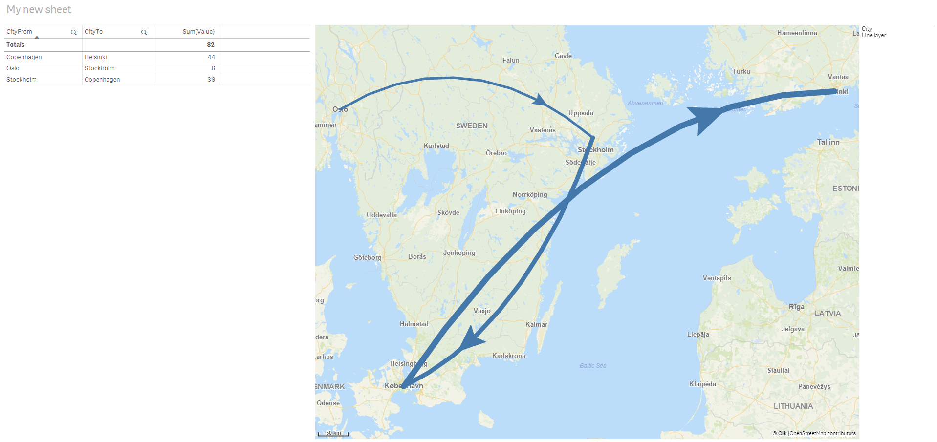
And you can play around with the settings afterwards.
Basically you need in your data model something that tells where something originated and where it is going to. Either by a name Qlik Sense can do lookups on or by adding a long / lat value so that you can use that.
Also added the app as an attachment.
Lykke til 
- Mark as New
- Bookmark
- Subscribe
- Mute
- Subscribe to RSS Feed
- Permalink
- Report Inappropriate Content
Here is a .kmz file that i have exported from arcgis. But i don't have a qlik sense app since I cannot import lines to qlik.
- Mark as New
- Bookmark
- Subscribe
- Mute
- Subscribe to RSS Feed
- Permalink
- Report Inappropriate Content
Thanks Ali. But I need to import several lines to Qlik so I was wondering which format the lines should have. For points and areas, KML files works fine, but not for lines.
- Mark as New
- Bookmark
- Subscribe
- Mute
- Subscribe to RSS Feed
- Permalink
- Report Inappropriate Content
I'm not sure what you mean by "format the lines should have".
The lines are formed between two places so you ned to know where does the line line originate from and where does it need to go to.
You shouldn't have to focus on what format the line has in an ArcGIS solution, instead see if you can in your data where a value originates and where it is going to and have this in your QlikSense data model.
Do you have this kind of info in the datamodel?
That is sufficient to create the line layers.
Not sure if I am misunderstanding?
- Mark as New
- Bookmark
- Subscribe
- Mute
- Subscribe to RSS Feed
- Permalink
- Report Inappropriate Content
With format I mean data type, like .excel or .KML
I have generated start, mid and end points for the line, but i still don't get Qlik to display the lines.
I have also created several points for the line (vertices) with coordinates. But it will only plot as points.
Thanks for helping me!
Please see attached app at the original post
- Mark as New
- Bookmark
- Subscribe
- Mute
- Subscribe to RSS Feed
- Permalink
- Report Inappropriate Content
Hi,
Could you share the Excel file with the row info for G1987 and the columns START_X, START_Y etc.
?
- Mark as New
- Bookmark
- Subscribe
- Mute
- Subscribe to RSS Feed
- Permalink
- Report Inappropriate Content
Yes, I have now attached the excel file to the original post.
- Mark as New
- Bookmark
- Subscribe
- Mute
- Subscribe to RSS Feed
- Permalink
- Report Inappropriate Content
Hi,
I tried myself and can't get it to work 😕
It reads the point when using the GeoMakePoint() function, but not otherwise.
Find it strange.
Any input on this mto?
Best,
Ali A
- « Previous Replies
-
- 1
- 2
- Next Replies »