Unlock a world of possibilities! Login now and discover the exclusive benefits awaiting you.
Announcements
Accelerate Your Success: Fuel your data and AI journey with the right services, delivered by our experts.
Learn More
- Qlik Community
- :
- Forums
- :
- Analytics
- :
- App Development
- :
- géo qliksens
Options
- Subscribe to RSS Feed
- Mark Topic as New
- Mark Topic as Read
- Float this Topic for Current User
- Bookmark
- Subscribe
- Mute
- Printer Friendly Page
Turn on suggestions
Auto-suggest helps you quickly narrow down your search results by suggesting possible matches as you type.
Showing results for
Anonymous
Not applicable
2018-04-02
10:14 AM
- Mark as New
- Bookmark
- Subscribe
- Mute
- Subscribe to RSS Feed
- Permalink
- Report Inappropriate Content
géo qliksens
Hi, I'm creating a map using Qlik Sense, following some instruction videos on Qlik Sense, but strangely after I load my data with lat and long, I still have no dimensions available to create the map when I click the "Add Dimension" button. Please see a screen shot that I added here and in the database I do not have the fields of "longitude,latitude"
What did I miss here? Thanks for help!
368 Views
2 Replies
Employee
2018-04-02
09:15 PM
- Mark as New
- Bookmark
- Subscribe
- Mute
- Subscribe to RSS Feed
- Permalink
- Report Inappropriate Content
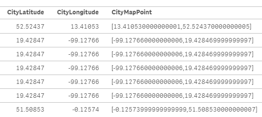
GeoMakePoint will work if the two fields you are using contain the latitude and longitude points to combine together for the location.
315 Views
Anonymous
Not applicable
2018-04-03
07:06 AM
Author
- Mark as New
- Bookmark
- Subscribe
- Mute
- Subscribe to RSS Feed
- Permalink
- Report Inappropriate Content
hey , but in my database i don't have the fileds (latitude , longitude) how do i get it done for working ?
315 Views
Community Browser