Unlock a world of possibilities! Login now and discover the exclusive benefits awaiting you.
- Qlik Community
- :
- All Forums
- :
- QlikView App Dev
- :
- UK PostCode District Area Map
- Subscribe to RSS Feed
- Mark Topic as New
- Mark Topic as Read
- Float this Topic for Current User
- Bookmark
- Subscribe
- Mute
- Printer Friendly Page
- Mark as New
- Bookmark
- Subscribe
- Mute
- Subscribe to RSS Feed
- Permalink
- Report Inappropriate Content
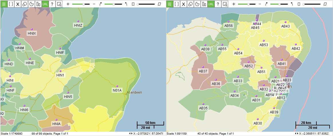
UK PostCode District Area Map
Has anyone mapped data to UK postcode districts and produced a visualisation. What is the best method of doing this?
Regards
Declan
Accepted Solutions
- Mark as New
- Bookmark
- Subscribe
- Mute
- Subscribe to RSS Feed
- Permalink
- Report Inappropriate Content
One of my personal contacts giving an update - eventually found it again. The guys name is Chris Evers, QlikView Developer.
- Mark as New
- Bookmark
- Subscribe
- Mute
- Subscribe to RSS Feed
- Permalink
- Report Inappropriate Content
Not yet, but someone posted on Linkedin yesterday that they are doing it.
- Mark as New
- Bookmark
- Subscribe
- Mute
- Subscribe to RSS Feed
- Permalink
- Report Inappropriate Content
Roger
Thank you . Do you have a link to the Post ?
Regards
Declan
- Mark as New
- Bookmark
- Subscribe
- Mute
- Subscribe to RSS Feed
- Permalink
- Report Inappropriate Content
One of my personal contacts giving an update - eventually found it again. The guys name is Chris Evers, QlikView Developer.
- Mark as New
- Bookmark
- Subscribe
- Mute
- Subscribe to RSS Feed
- Permalink
- Report Inappropriate Content
Hi Declan,
We include postal code areas for UK in our extension IdevioMaps for QlikView or Qlik Sense. We can send you an example app if you´d like.
Cheers
/
Jonas Karlsson
Idevio