Unlock a world of possibilities! Login now and discover the exclusive benefits awaiting you.
Announcements
April 13–15 - Dare to Unleash a New Professional You at Qlik Connect 2026: Register Now!
- Qlik Community
- :
- All Forums
- :
- QlikView Integrations
- :
- World countries as Shape Files for free "qlikmap" ...
Options
- Subscribe to RSS Feed
- Mark Topic as New
- Mark Topic as Read
- Float this Topic for Current User
- Bookmark
- Subscribe
- Mute
- Printer Friendly Page
Turn on suggestions
Auto-suggest helps you quickly narrow down your search results by suggesting possible matches as you type.
Showing results for
Partner Ambassador
2014-03-31
11:19 AM
- Mark as New
- Bookmark
- Subscribe
- Mute
- Subscribe to RSS Feed
- Permalink
- Report Inappropriate Content
World countries as Shape Files for free "qlikmap" extension
The .KML file format is an XML format used by Google Earth to describe places, paths, and polygons. The countries of the world are available in that format. The good thing with .KML is, this format is exactly the same as QlikTech's free "qlikmap" extension requires it. Therefore, you can turn the qlikmap extension with OpenStreetMap in the background, with drag and zoom features, together with the polygone map into a country heat map.
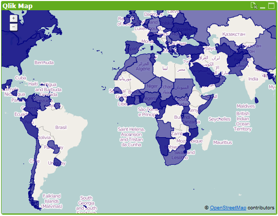
Links:
- KML file of the world's countries: http://www.rjruss.info/2010/12/free-countries-of-world-in-polygon-kml.html
- Get the "qlikmap" extension https://github.com/brianwmunz/QuickMap-QV11 (it is part of QlikView 11.2 SR5 and higher, if you use this release, you don't need to download it)
Related Article:
- Tags:
- qlikview_extensions
4,125 Views
0 Replies