Unlock a world of possibilities! Login now and discover the exclusive benefits awaiting you.
- Qlik Community
- :
- All Forums
- :
- QlikView App Dev
- :
- make static map with scatter chart
- Subscribe to RSS Feed
- Mark Topic as New
- Mark Topic as Read
- Float this Topic for Current User
- Bookmark
- Subscribe
- Mute
- Printer Friendly Page
- Mark as New
- Bookmark
- Subscribe
- Mute
- Subscribe to RSS Feed
- Permalink
- Report Inappropriate Content
make static map with scatter chart
Hi everybody
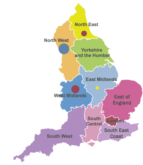
I want to create a scatter chart like picture
I don't want to use google map.
i want to use pictures for my country.
best wishes
behrang
- Tags:
- new_to_qlikview
Accepted Solutions
- Mark as New
- Bookmark
- Subscribe
- Mute
- Subscribe to RSS Feed
- Permalink
- Report Inappropriate Content
You need to create a scatter chart with the country image as a background. Next, figure out the chart co-ordinates (X and Y) for each data point (Region). After that, create a table in the script, containing Region, X, and Y, something like this:
Region_Location:
LOAD * INLINE [
Region, X, Y
North East, 20, 15
...
];
In the scatter chart, use these coordinates as the first two expressions, and the 3rd expression will define the data point size. Region will be the chart dimension.
Hope it helps.