Unlock a world of possibilities! Login now and discover the exclusive benefits awaiting you.


 Michael_Tarallo
- Subscribe to RSS Feed
- Mark as New
- Mark as Read
- Bookmark
- Subscribe
- Printer Friendly Page
- Report Inappropriate Content
Add the Geographical Dimension to your Business Data
Hello Qlik Community! I know most of you never sleep, but some of us took some much needed time off. I welcome you back from your much deserved holiday and I wish you all a prosperous new year. Now, let's get back to work! 
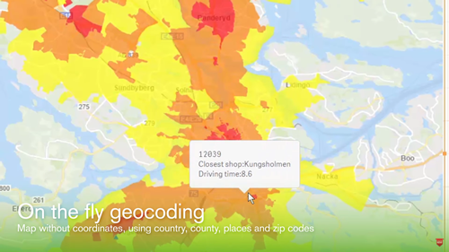
We are looking forward to a fantastic year @Qlik, and the greatness has already started to roll in. On January 4th we announced the acquisition of Idevio, a provider of geographical-related software and services, and a valued Sweden-based Qlik partner. This acquisition not only extends Qlik’s current mapping capabilities, but also moves its offerings beyond visualization with support for a broader range of advanced geoanalytic use cases. Users can now easily add maps to their apps with automatic geo-data lookup to reveal spatial information and then overlay it with different visualizations. You can drill down into information dense maps that contain millions of points, and with a local or cloud-based service, analyze geo-data in combination with non-geo data for use cases such as determining potential store locations, understanding customer distribution of sales by zip code, or calculating supply chain delivery times. IdevioMaps, which includes Idevio GeoAnalytics for QlikView and Qlik Sense, has been re-branded as Qlik GeoAnalytics and is available immediately in its current offering, with tighter integration in Qlik Sense planned for the second half of 2017. You can learn more about what Qlik GeoAnalytics has to offer in this brief introductory video.
Come visit the new Qlik GeoAnalytics Community to post your questions and join the conversation about Qlik GeoAnalytics.
- Note: For samples, examples, guides using Qlik GeoAnalytics visit here
- Primer on using Qlik GeoAnalytics with QlikView - Getting Started with GeoAnalytics
- Primer on using Qlik GeoAnalytics with Qlik Sense - Getting Started
My 2¢
I am very excited about this capability as part of the Qlik product portfolio. When I joined Qlik in 2012, I was always curious as to why there weren't any mapping visualizations with QlikView. Naturally, with Qlik's disruption to the traditional BI vendors, you would think we would have some sort of maps! Hey, everyone was doing it, why not Qlik? (I was so envious of those pretty maps!) I eventually realized that Qlik knew geospatial analytics required more than just dots on a map and was waiting for consumerization to catch up to mapping. But by the time that happened we were neck deep in developing our next generation data visualization platform "QlikView.Next" which lovingly became Qlik Sense. So that really kept us from bringing the strategic focus to bear that we needed to to build out our own mapping capabilities organically. (As some of you may recall, this gap was filled in QlikView with a technique that utilized a scatter plot with a Google Maps background.) At that time, our valuable partner network recognized this as an great opportunity and stepped in with a variety of mapping solutions and extensions designed for varying needs. Idevio maps was one of those partners. Just like many companies, Qilk invests in its existing resources where it can excel quickly and provide immediate value to its customers. As time allows, it will continue to grow its expert family and capabilities through acquisitions that will enhance that value to its customers. We have seen this with the acquisition of Expressor (data governance, data management), NComVA (advanced visualizations) Vizubi / NPrinting (creation, schedule, distribution of operational reports) and now Idevio. Hmmmm, I wonder what's next? Looking forward to a prosperous 2017. Stay well my friends!
Tell me what do you think. Leave your comments below.
Regards,
Michael Tarallo
Follow me: https://twitter.com/mtarallo
Qlik
- « Previous
-
- 1
- 2
- Next »
You must be a registered user to add a comment. If you've already registered, sign in. Otherwise, register and sign in.