Unlock a world of possibilities! Login now and discover the exclusive benefits awaiting you.
- Qlik Community
- :
- All Forums
- :
- GeoAnalytics
- :
- Get points and Shapes from an ArcGIS server
- Subscribe to RSS Feed
- Mark Topic as New
- Mark Topic as Read
- Float this Topic for Current User
- Bookmark
- Subscribe
- Mute
- Printer Friendly Page
- Mark as New
- Bookmark
- Subscribe
- Mute
- Subscribe to RSS Feed
- Permalink
- Report Inappropriate Content
Get points and Shapes from an ArcGIS server
Hi All,
I am looking for a way to use/import shapes, points, lines and basemaps that are available on a ArcGIS server.
The maps are available in WMS format and shapes, point, lines are available through a JSON query.
How can we achieve this.
If I can trust this post, it should be possible,but how??
New IdevioMaps and GeoAnalytics features « bi.idevio.com
Thanks, Frank
Accepted Solutions
- Mark as New
- Bookmark
- Subscribe
- Mute
- Subscribe to RSS Feed
- Permalink
- Report Inappropriate Content
Ok, Esri JSON is not supported that way, WFS GeoJSON and WFS GML is.
You can load the WFS using the connector and the "Load" function.
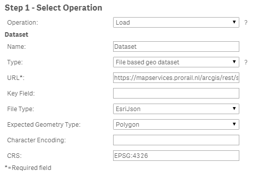
See the attached sense app for details
Thanks,
Patric
- Mark as New
- Bookmark
- Subscribe
- Mute
- Subscribe to RSS Feed
- Permalink
- Report Inappropriate Content
Hi,
Please see this doc on how to connect to dynamic WFS using Qlik GeoAnalytics:
Setting up a Esri ArcGIS WFS source as a layer in Qlik GeoAnalytics (QGA)
Thanks,
Patric Nordström
Qlik
- Mark as New
- Bookmark
- Subscribe
- Mute
- Subscribe to RSS Feed
- Permalink
- Report Inappropriate Content
Hi Patric,
This helps a lot and your example works. But I have an issue with my own example. I cannot select as 'GeoJson' as an output with the get. I can only select 'JSON, HTML, AMF or KMZ'. Is it also possible with a JSON output? (or one of the others?)
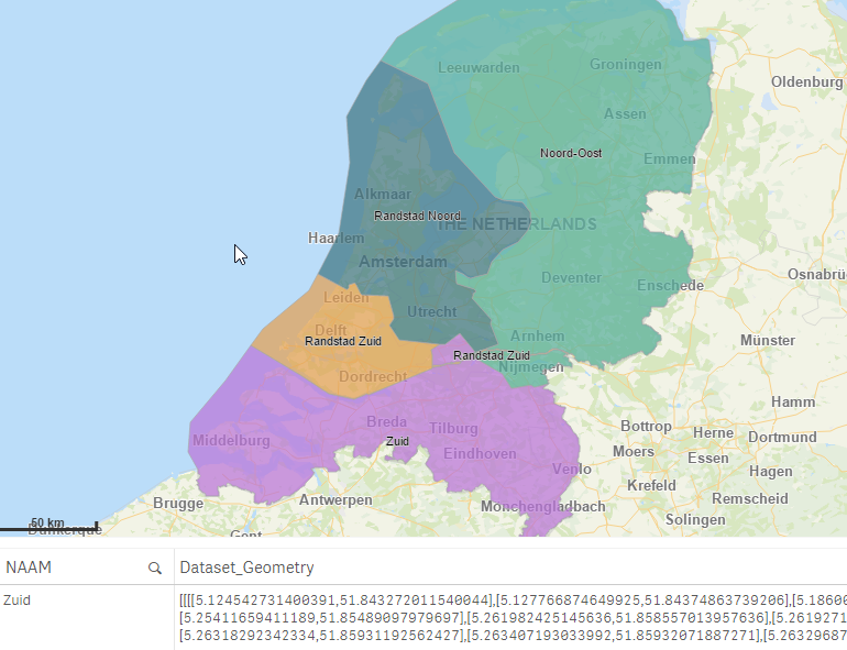
Please check: Query: ProRail regio's (ID: 4)
Frank
- Mark as New
- Bookmark
- Subscribe
- Mute
- Subscribe to RSS Feed
- Permalink
- Report Inappropriate Content
Ok, Esri JSON is not supported that way, WFS GeoJSON and WFS GML is.
You can load the WFS using the connector and the "Load" function.
See the attached sense app for details
Thanks,
Patric